Fort de Buade

Last updated
Fort de Buade
2009-0618-StIgnace-MuseumMission.jpg
Museum of Ojibwa Culture
TypeFort
Site information
Controlled by New France
Site history
Built1683
In use1683-1701
Battles/warsIroquois Wars - War with the English

Fort de Buade was a French fort in the present U.S. state of Michigan's Upper Peninsula across the Straits of Mackinac from the northern tip of lower Michigan's "mitten". It was garrisoned between 1683 and 1701. The city of St. Ignace developed at the site, which also had the historic St. Ignace Mission founded by Jesuits. The fort was named after New France's governor at the time, Louis de Buade de Frontenac.

Contents

Mission

The French-Canadian settlement at St. Ignace began with the Mission of Saint Ignace, founded by Father Jacques Marquette, S.J. in 1671. By 1680 it had become a considerable community consisting of the mission, a French village of a dozen cabins, a Wyandot (Huron) Indian village surrounded by a wooden palisade and an adjacent Odawa (Ottawa) village, also behind a palisade. In 1681, the Huron and Illiniwek at St. Ignace killed the Seneca chief Annanhac, who had been leading his forces against the western peoples. The Seneca were part of the Iroquois Confederacy based in present-day New York state.

Sharp practice by the fur traders also caused tensions. In 1683, Governor Joseph-Antoine de La Barre ordered Daniel Greysolon, Sieur du Lhut and Olivier Morel de La Durantaye to establish a strategic presence on the north shore of the Straits of Mackinac, connecting Lake Michigan and Lake Huron of the Great Lakes. They fortified the Jesuit mission and La Durantaye settled in as overall commander of the French forts in the northwest: Fort Saint Louis des Illinois (Utica, Illinois); Fort Kaministigoya (Thunder Bay, Ontario); and Fort la Tourette (Lake Nipigon, Ontario). He was also responsible for the region around Green Bay in present-day Wisconsin.

In the spring of 1684, La Durantaye led a relief expedition from Saint Ignace to Fort Saint Louis des Illinois, which had been besieged by the Seneca as part of the Beaver Wars as they sought to gain more hunting ground to control the lucrative fur trade. That summer, and again in 1687, La Durantaye led coureurs de bois and Indians from the Straits against the Seneca homeland in upstate New York. During these years, English traders from New York entered the Great Lakes and traded at Michilimackinac. This, and the outbreak of war between England and France in 1689, led to the construction of Fort de Buade in 1690 by the new commandant Louis de La Porte de Louvigné.

Forts

Fort de Buade at St. Ignace

During the 1690s, the fort became a staging area for French and Indian attacks against the Seneca, who were then allied to the English. It remained an important fur trading center and a distribution point for arms and munitions for the war against the Iroquois. In 1694 Governor Louis de Buade de Frontenac sent an aggressive young protégé, Antoine de la Mothe Cadillac, to run the post. Cadillac made a small fortune as the post commander, possibly by collecting bribes. In 1697, the Huron chief Kondiaronk from Michilimackinac led an attack on the Seneca at Lake Erie. He gained a crushing victory and dashed the Seneca hopes for victory against the French. Four years later, Kondiaronk took a leading role in forging the Great Peace of Montreal, which would conclude the war.

Relations between the fort and the adjacent Jesuit mission were not good during Cadillac's tenure. La Durantaye had ruled Michilimackinac with a firm hand. He controlled the trade in brandy, policed the fur trade, and kept the traders in line. An honest man, he would spend the last years of his life in relative poverty. Cadillac did not hold to these standards. He brought in for sale much of the alcohol at the post. The missionaries, led by Etienne de Carheil, accused Cadillac of encouraging the sale and trading of brandy to the Native Americans. Cadillac may have seen this move as a necessary tactic to check the English traders. In any case, he used it as a tactic in his own financial plans.

Despite Cadillac's liquor trade, Anglo-French commercial competition continued. Cadillac was replaced as commandant by Alphonse Tonti, brother of the explorer Henri de Tonti. In 1701, Cadillac asked permission from Paris to found a new post on the Detroit River, to interdict the flow of British trade goods into the Lake Huron area. In that sense, the Fort de Buade garrison was related to development of the future city of Detroit.

The final fate of Fort de Buade is unclear. After the withdrawal of the garrison, coureurs de bois continued to frequent Michilimackinac. Governor Philippe de Rigaud Vaudreuil used these traders to smuggle goods to the northern nations during the War of the Spanish Succession, despite the objections of Jérôme Phélypeaux, comte de Pontchartrain. Among his agents was the voyageur Daniel Amiot de Villeneuve. Unless the fort was destroyed when the garrison was evacuated, Vaudreuil's men likely used it to store goods intended for the Indians, until the new fort was completed on the south side of the Straits (1715). After this date few French remained at East Moran Bay. The fort was either destroyed or fell into disrepair and eventually disappeared.

The 1690-1701 Fort de Buade was probably built as a wooden stockade. It is believed to have been located on a site within the current municipality of St. Ignace, possibly on a hill above East Moran Bay locally called "Fort Hill." The fort could also have been located on the bay's waterfront. As of October 2022 the fort's remains had not yet been found.

Successor fort near Mackinaw City

Between 1701 and 1715 there was no official French-Canadian presence at the Straits of Mackinac. Unlicensed fur trading by coureurs des bois no doubt continued during this period. In 1715 a French detachment under Constant le Marchand de Lignery re-established a presence at the Straits of Mackinac to prepare for war against the Fox nation in Wisconsin (Fox Wars). The new post, called Fort Michilimackinac, was built on the south shore of the Straits. Present-day Mackinaw City, Michigan developed near it. Most of the Huron migrated south to Detroit with Cadillac in 1701. The Ottawa moved from East Moran Bay to the new fort, and the St. Ignace area was largely abandoned until the nineteenth century.

Related Research Articles

<span class="mw-page-title-main">Mackinac Island</span> Island in Michigan, United States

Mackinac Island is an island and resort area, covering 4.35 square miles (11.3 km2) in land area, in the U.S. state of Michigan. The name of the island in Odawa is Michilimackinac and "Mitchimakinak" in Ojibwemowin meaning "Great Turtle". It is located in Lake Huron, at the eastern end of the Straits of Mackinac, between the state's Upper and Lower Peninsulas. The island was long home to an Odawa settlement and previous indigenous cultures before European colonization began in the 17th century. It was a strategic center of the fur trade around the Great Lakes. Based on a former trading post, Fort Mackinac was constructed on the island by the British during the American Revolutionary War. It was the site of two battles during the War of 1812 before the northern border was settled and the US gained this island in its territory.

<span class="mw-page-title-main">Mackinac County, Michigan</span> County in Michigan, United States

Mackinac County is a county in the Upper Peninsula of the U.S. state of Michigan. As of the 2020 census, the population was 10,834. The county seat is St. Ignace. Formerly known as Michilimackinac County, in 1818 it was one of the first counties of the Michigan Territory, as it had long been a center of French and British colonial fur trading, a Catholic church and Protestant mission, and associated settlement.

<span class="mw-page-title-main">St. Ignace, Michigan</span> City in Michigan, United States

St. Ignace is a city in the U.S. state of Michigan and the county seat of Mackinac County. The city had a population of 2,306 at the 2020 census. St. Ignace Township is located just to the north of the city, but the two are administered autonomously.

<span class="mw-page-title-main">Mackinaw City, Michigan</span> Village in Michigan, United States

Mackinaw City is a village at the northernmost point of the Lower Peninsula of Michigan. Divided between Cheboygan and Emmet counties, Mackinaw City is the located at the southern end of the Mackinac Bridge, which carries Interstate 75 over the Straits of Mackinac to the Upper Peninsula. Mackinaw City, along with St. Ignace, serves as an access point to Mackinac Island. For these reasons, Mackinaw City is considered one of Michigan's most popular tourist attractions.

<span class="mw-page-title-main">Antoine de la Mothe Cadillac</span> French explorer in North America (1658–1730)

Antoine de la Mothe, sieur de Cadillac, born Antoine Laumet, was a French explorer and adventurer in New France, which stretched from Eastern Canada to Louisiana on the Gulf of Mexico. He rose from a modest beginning in Acadia in 1683 as an explorer, trapper, and a trader of alcohol and furs, achieving various positions of political importance in the colony. He was the commander of Fort de Buade in St. Ignace, Michigan, in 1694. In 1701, he founded Fort Pontchartrain du Détroit ; he was commandant of the fort until 1710. Between 1710 and 1716, he was the governor of Louisiana, although he did not arrive in that territory until 1713.

<span class="mw-page-title-main">Great Peace of Montreal</span> 1701 peace treaty between New France and First Nations

The Great Peace of Montreal was a peace treaty between New France and 39 First Nations of North America that ended the Beaver Wars. It was signed on August 4, 1701, by Louis-Hector de Callière, governor of New France, and 1300 representatives of 39 Indigenous nations.

<span class="mw-page-title-main">Straits of Mackinac</span> Strait connecting Lakes Huron and Michigan in Michigan, USA

The Straits of Mackinac are the short waterways between the U.S. state of Michigan's Upper and Lower Peninsulas, traversed by the Mackinac Bridge. The main strait is 3+12 miles wide with a maximum depth of 295 feet, and connects the Great Lakes of Lake Michigan and Lake Huron. Given the large size and configuration of the straits, hydrologically, the two connected lakes are one body of water, studied as Lake Michigan–Huron. Historically, the native Odawa people called the region around the Straits Michilimackinac.

<span class="mw-page-title-main">Fort Michilimackinac</span> Archaeological site in Michigan, United States

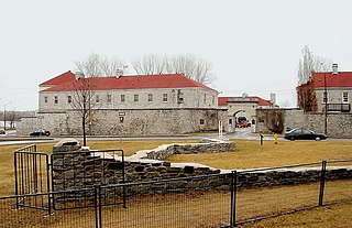
Fort Michilimackinac was an 18th-century French, and later British, fort and trading post at the Straits of Mackinac; it was built on the northern tip of the lower peninsula of the present-day state of Michigan in the United States. Built around 1715, and abandoned in 1783, it was located along the Straits, which connect Lake Huron and Lake Michigan of the Great Lakes of North America.

<span class="mw-page-title-main">Fort Frontenac</span> French fort in Kingston, Ontario, Canada

Fort Frontenac was a French trading post and military fort built in July 1673 at the mouth of the Cataraqui River where the St. Lawrence River leaves Lake Ontario, in a location traditionally known as Cataraqui. It is the present-day location of Kingston, Ontario, Canada. The original fort, a crude, wooden palisade structure, was called Fort Cataraqui but was later named for Louis de Buade de Frontenac, Governor of New France who was responsible for building the fort. It was abandoned and razed in 1689, then rebuilt in 1695.

Michilimackinac is derived from an Ottawa Ojibwe name for present-day Mackinac Island and the region around the Straits of Mackinac between Lake Huron and Lake Michigan. Early settlers of North America applied the term to the entire region along Lakes Huron, Michigan, and Superior. Today it is considered to be mostly within the boundaries of Michigan, in the United States. Michilimackinac was the original name for present day Mackinac Island and Mackinac County.

<span class="mw-page-title-main">Northern Michigan</span> Northern region of Michigans lower peninsula

Northern Michigan, also known as Northern Lower Michigan, is a region of the U.S. state of Michigan. A popular tourist destination, it is home to several small- to medium-sized cities, extensive state and national forests, lakes and rivers, and a large portion of Great Lakes shoreline. The region has a significant seasonal population much like other regions that depend on tourism as their main industry. Northern Lower Michigan is distinct from the more northerly Upper Peninsula and Isle Royale, which are also located in "northern" Michigan. In the northernmost 21 counties in the Lower Peninsula of Michigan, the total population of the region is 506,658 people.

<span class="mw-page-title-main">Fort Michilimackinac State Park</span> State park in Michigan, United States

Fort Michilimackinac State Park is a state park in the U.S. state of Michigan. It is located in Mackinaw City along the Straits of Mackinac. The park contains Fort Michilimackinac, which itself is dedicated a National Historic Landmark and Old Mackinac Point Lighthouse as well as the Old Mackinac Point Lighthouse Signal Tower which contains a foghorn.

<i>Pays den Haut</i> 1610–1763 territory of New France

The Pays d'en Haut was a territory of New France covering the regions of North America located west of Montreal. The vast territory included most of the Great Lakes region, expanding west and south over time into the North American continent as the French had explored. The Pays d'en Haut was established in 1610 and dependent upon the colony of Canada until 1763, when the Treaty of Paris ended New France, and both were ceded to the British as the Province of Quebec.

L'Arbre Croche, known by the Odawa people as Waganagisi, was a large Odawa settlement in Northern Michigan. The French called it L'Arbre Croche for the large crooked tree that marked the center of the settlement and was visible for many miles. It covered the region from Harbor Springs to Cross Village in present-day Emmet County, Michigan.

<span class="mw-page-title-main">Kondiaronk</span> Native American Wyandot leader

Kondiaronk, known as Le Rat, was Chief of the Native American Wendat people at Michilimackinac in New France. As a result of an Iroquois attack and dispersal of the Hurons in 1649, the latter settled in Michilimackinac. The Michilimackinac area refers to the strait between Lakes Huron and Michigan in the present day United States.

<span class="mw-page-title-main">Henri Nouvel</span>

Henri Nouvel was a Jesuit priest who spent forty years as a missionary to Native American communities of New France. Nouvel was the first missionary on the north shore of the Saint Lawrence River; and he visited Saginaw 26 years before the French built a fort in Detroit (1701).

<span class="mw-page-title-main">Sainte Anne Church (Mackinac Island)</span> Roman Catholic church in Michigan, USA

Sainte Anne Church is a Roman Catholic church located in the city of Mackinac Island in the U.S. state of Michigan.

Joseph Marest was a Jesuit missionary in New France in the late 1600s and early 1700s. He is known chiefly for remaining in Michilimackinac/ St. Ignace Mission as missionary to the Ottawas after Antoine de la Mothe Cadillac moved the center of the French fur trade from Fort de Buade to Fort Detroit in 1701.

References

45°52′02″N84°43′23″W / 45.86722°N 84.72306°W / 45.86722; -84.72306