Canada (New France)

Last updated
Canada
1535–1763
Pavillon royal de la France.svg
The royal banner of early modern France or "Bourbon Flag" was the most commonly used flag in New France [1] [2] [3]
Coat of Arms of France.svg
The lesser coat of arms of France
as used by the Government
Canada (New France) Location Map.svg
Map of Canada after 1713. At its fullest extent, Canada extended from south of the Great Lakes to the Gulf of St Lawrence.
StatusColony of France within New France
Capital Quebec
Common languages French
Religion
Catholic Church (state religion) [4]
Government Monarchy
King  
Governor  
History 
 French territorial possession
1535
 Founding of Quebec
1608
 Founding of Trois-Rivières
1634
 Founding of Montreal
1642
1763
Currency New France livre
ISO 3166 code CA
Preceded by
Succeeded by
Blank.png Aboriginal peoples in Canada
Province of Quebec (1763–1791) Flag of Great Britain (1707-1800).svg
Today part of Canada
United States

The colony of Canada was a French colony within the larger territory of New France. It was claimed by France in 1535 during the second voyage of Jacques Cartier, in the name of the French king, Francis I. The colony remained a French territory until 1763, when it became a British colony known as the Province of Quebec. [5] [6] [7] [8]

Contents

In the 16th century the word "Canada" could refer to the territory along the Saint Lawrence River [9] (then known as the Canada River) from Grosse Isle to a point between Québec and Trois-Rivières. [10] The terms "Canada" and "New France" were also used interchangeably. [11] French explorations continued west "unto the Countreys of Canada, Hochelaga, and Saguenay" [12] before any permanent settlements were established. In 1600 a permanent trading post and habitation was established at Tadoussac at the confluence of the Saguenay and Saint Lawrence rivers. However, because this trading post was under a trade monopoly, it was not constituted as an official French colonial settlement.

The first official settlement of Canada was Québec, founded by Samuel de Champlain in 1608. [13] [14] The other four colonies within New France were Hudson's Bay to the north, Acadia and Newfoundland to the east, and Louisiana far to the south. [15] [16] Canada became the most developed of the five colonies of New France. It was divided[ when? ] into three districts, Québec, Trois-Rivières, and Montreal, each with its own government.[ citation needed ] The governor of the District of Quebec also served as the governor-general for all of New France. [16] [ failed verification ]

The Seven Years' War of 1756–1763 saw Great Britain defeat the French and their allies, and take possession of Canada. In the Treaty of Paris of 1763, which formally ended the Seven Years' War, France ceded Canada in exchange for other colonies, with a large portion of Canada becoming the British colony of the Province of Quebec. [17]

Territorial evolution

In the 240 years between Verrazano's voyage of exploration in 1524 and the Conquest of New France in 1763, the French marked the North American continent in many ways. Whether it was through by land distribution and clearing, the establishment of villages and towns, deploying a network of roads and paths or developing the territory with various constructions, the French colonists transformed and adapted the environments according to their needs.

There are three major periods of expansion of the territory of Canada, mostly as a result of exploration efforts. First, the 1534–1603 period, in which Canada's territory comprised the coasts of Newfoundland, the entirety of Prince Edward Island, Nova Scotia and the coasts of New Brunswick, the Saint Lawrence River and the Gulf of Saint Lawrence.

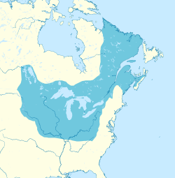
Then 1603–1673, in which, due to westward expansion and conflicts with Great Britain, the Canada territory was now composed of the coasts of the Saint Lawrence River, of the Gulf of Saint Lawrence and of the Great Lakes, as well as southern Ontario and northern New England.

Then, in the last period of 1673–1741, the Canada territory was composed of the coasts of the Saint Lawrence River, of the Gulf of Saint Lawrence and of the Great Lakes, southern Ontario, southern Manitoba and the north-eastern Midwest. It is in this period that Canada was at its largest. [18]

Pays d'en Haut

Lower Louisiana marked in yellow; pink represents Canada. Part of Canada south of the Great Lakes was ceded to Louisiana in 1717. Brown represents British colonies. Original map from 1719 La Nouvelle-France.jpg
Lower Louisiana marked in yellow; pink represents Canada. Part of Canada south of the Great Lakes was ceded to Louisiana in 1717. Brown represents British colonies. Original map from 1719

Dependent on Canada were the Pays d'en Haut (upper countries), a vast territory north and west of Montreal, covering the whole of the Great Lakes and stretching as far into the North American continent as the French had explored. [16] Before 1717, when it ceded territory to the new colony of Louisiana, it stretched as far south as the Illinois Country. In the Great Lakes area, a mission, Sainte-Marie among the Hurons, was established in 1639. Following the destruction of the Huron homeland in 1649 by the Iroquois, the French destroyed the mission themselves and left the area. In what are today Ontario and the eastern prairies, various trading posts and forts were built such as Fort Kaministiquia in 1679 (at modern Thunder Bay, Ontario), Fort Frontenac in 1673 (today's Kingston, Ontario), Fort Saint Pierre in 1731 (near modern Fort Frances, Ontario), Fort Saint Charles in 1732 (on Lake of the Woods located on Magnusens Island on the Northwest Angle of Minnesota) and Fort Rouillé in 1750 (today's Toronto). The mission and trading post at Sault Ste. Marie (1688) would later be split by the Canada–US border.

The French settlements in the Pays d'en Haut among and south of the Great Lakes were Fort Niagara (1678) (near modern Youngstown, New York), Fort Crevecoeur (1680) (near the present site of Creve Coeur, Illinois, a suburb of Peoria, Illinois), Fort Saint Antoine (1686) (on Lake Pepin in Wisconsin), Fort St. Joseph (1691) (on the southernmost point of St. Joseph Island, Ontario on Lake Huron), Fort Pontchartrain du Détroit (1701) (today's Detroit, Michigan), Fort Michilimackinac (1715) (on the Straits of Mackinac at Mackinaw City, Michigan), Fort Miami (1715) (modern Fort Wayne, Indiana), Fort La Baye (1717) (today's Green Bay, Wisconsin), and Fort Beauharnois (1727) (in Florence Township, Goodhue County, Minnesota).

Today, the term Les Pays-d'en-Haut refers to a regional county municipality in the Laurentides region of the present Province of Quebec, north of Montreal, while the former Pays d'en Haut was part of the District of Montreal.

Domaine du roy

The Domaine du roy , established in 1652, was a vast region of New France, which stretched north from the St. Lawrence River to Hudson Bay. It was located between the eastern limit of the seigneurie of Les Éboulements and Cape Cormorant. The territory had an area of more than 460,000km2. After the Conquest of New France, the territory's name was changed to Rupert's Land. [19]

Population surveys

A population survey was done in 1740 to estimate Canada's population. The survey of the Saint Lawrence River valley counted about 44,000 colonists in total. The majority of them were born in Canada and lived in a rural environment. Of the colonists, 18,000 lived under the Government of Québec, 4,000 under the Government of Trois-Rivières and 22,000 under the Government of Montreal. As for colonists not living in the Saint Lawrence River valley, Île Royale (now Cape Breton) counted 4,000 inhabitants (of which 1,500 were in Louisbourg), and Île Saint-Jean (now Prince Edward Island) had 500 inhabitants. [20]

Successors and legacy

In 1791, the Province of Quebec was separated into Lower Canada (now Quebec) and Upper Canada (now Ontario). Lower Canada and Upper Canada were fused into the Province of Canada in 1841, before separating again into the modern-day provinces of Quebec and Ontario during the Confederation of Canada in 1867. Because of the historical and geographical continuity, as well as the continued use of the French language, civil law, customs, cultural aspects and the ruling power of the Catholic Church in government until the Quiet Revolution of the 1960s, the province of Quebec is considered by many to be the modern-day continuation of the Canada colony of New France. [21] [22] [23] [24] Still today, the majority of the Quebec population is descended from the original French-speaking Canadien of Canada, and the cultural distinctiveness of Quebec from the rest of the country has led to the emergence of a Québécois identity and the Quebec sovereignty movement. [25] Descendants of the original Canadien of Canada (New France) living outside of Quebec are now often referred to by a name which references their province of residence (ex. Franco-Ontarian). Francophone populations in the Maritime provinces, however, are more likely to be descended from the settlers of the French colony of Acadia. They are therefore called Acadians.

See also

Related Research Articles

<span class="mw-page-title-main">Lower Canada</span> 1791–1841 British colony in North America

The Province of Lower Canada was a British colony on the lower Saint Lawrence River and the shores of the Gulf of Saint Lawrence (1791–1841). It covered the southern portion of the current Province of Quebec and the Labrador region of the current Province of Newfoundland and Labrador.

<span class="mw-page-title-main">St. Lawrence River</span> Major river in eastern Canada and the United States, flowing into the Gulf of St. Lawrence

The St. Lawrence River is a large international river in the middle latitudes of North America connecting the Great Lakes to the North Atlantic Ocean. Its waters flow in a northeasterly direction from Lake Ontario to the Gulf of St. Lawrence, traversing Ontario and Quebec in Canada and New York in the United States. A section of the river demarcates the Canada–U.S. border.

<span class="mw-page-title-main">French colonization of the Americas</span> Part of Frances colonial empire

France began colonizing the Americas in the 16th century and continued into the following centuries as it established a colonial empire in the Western Hemisphere. France established colonies in much of eastern North America, on several Caribbean islands, and in South America. Most colonies were developed to export products such as fish, rice, sugar, and furs.

<span class="mw-page-title-main">Jacques Cartier</span> French maritime explorer of North America (1491–1557)

Jacques Cartier was a French-Breton maritime explorer for France. Jacques Cartier was the first European to describe and map the Gulf of Saint Lawrence and the shores of the Saint Lawrence River, which he named "The Country of Canadas" after the Iroquoian names for the two big settlements he saw at Stadacona and at Hochelaga.

<span class="mw-page-title-main">New France</span> Area colonized by France in North America

New France was the territory colonized by France in North America, beginning with the exploration of the Gulf of Saint Lawrence by Jacques Cartier in 1534 and ending with the cession of New France to Great Britain and Spain in 1763 under the Treaty of Paris.

<span class="mw-page-title-main">Province of Quebec (1763–1791)</span> British colony of Quebec from 1763 to 1791

The Province of Quebec was a colony in British North America which comprised the former French colony of Canada. It was established by the Kingdom of Great Britain in 1763, following the conquest of New France by British forces during the Seven Years' War. As part of the 1763 Treaty of Paris, France gave up its claim to the colony; it instead negotiated to keep the small profitable island of Guadeloupe.

<span class="mw-page-title-main">History of Quebec</span>

Quebec was first called Canada between 1534 and 1763. It was the most developed colony of New France as well as New France's centre, responsible for a variety of dependencies. Common themes in Quebec's early history as Canada include the fur trade — because it was the main industry — as well as the exploration of North America, war against the English, and alliances or war with Native American groups.

<span class="mw-page-title-main">Cap-Santé</span> City in Quebec, Canada

Cap-Santé is a town in the Canadian province of Quebec. It is the county seat of Portneuf Regional County Municipality and was as well the county seat of the designated Portneuf County.

<span class="mw-page-title-main">Montérégie</span> Administrative region in Quebec, Canada

Montérégie is an administrative region in the southwest part of Quebec. It includes the cities of Boucherville, Brossard, Châteauguay, Longueuil, Saint-Hyacinthe, Saint-Jean-sur-Richelieu, Salaberry-de-Valleyfield and Vaudreuil-Dorion.

<span class="mw-page-title-main">Name of Canada</span> Etymology of the countrys name

While a variety of theories have been postulated for the name of Canada, its origin is now accepted as coming from the St. Lawrence Iroquoian word kanata, meaning 'village' or 'settlement'. In 1535, indigenous inhabitants of the present-day Quebec City region used the word to direct French explorer Jacques Cartier to the village of Stadacona. Cartier later used the word Canada to refer not only to that particular village but to the entire area subject to Donnacona ; by 1545, European books and maps had begun referring to this small region along the Saint Lawrence River as Canada.

<span class="mw-page-title-main">French language in Canada</span>

French is the mother tongue of approximately 7.2 million Canadians according to the 2016 Canadian Census. Most Canadian native speakers of French live in Quebec, the only province where French is the majority and the sole official language. Of Quebec's people, 71.2 percent are native francophones and 95 percent speak French as their first or second language.

<span class="mw-page-title-main">Company of One Hundred Associates</span> French fur company in Canada (1627–1663)

The Company of One Hundred Associates, or Company of New France, was a French trading and colonization company chartered in 1627 to capitalize on the North American fur trade and to expand French colonies there. The company was granted a monopoly to manage the fur trade in the colonies of New France, which were at that time centered on the Saint Lawrence River valley and the Gulf of Saint Lawrence. In return, the company was supposed to settle French Catholics in New France. The Company of One Hundred Associates was dissolved by King Louis XIV, who incorporated New France into a province in 1663.

<span class="mw-page-title-main">History of Canada (1763–1867)</span> Colonial Canada

Starting with the 1763 Treaty of Paris, New France, of which the colony of Canada was a part, formally became a part of the British Empire. The Royal Proclamation of 1763 enlarged the colony of Canada under the name of the Province of Quebec, which with the Constitutional Act 1791 became known as the Canadas. With the Act of Union 1840, Upper and Lower Canada were joined to become the United Province of Canada.

Jean Bochart de Champigny, Sieur de Noroy et de Verneuil, was Intendant of New France from 1686 to 1702. His mandate was one of the longest, rivalling those of Hocquart and Bégon. He served as intendant during the terms of Governors Denonville, Frontenac, and Callière, and was in office at the time of King William's War, the Lachine Massacre, the Battle of Quebec, and the Great Peace of Montreal.

<span class="mw-page-title-main">Fort Saint-Jean (Quebec)</span> Historic military garrison in Quebec, Canada

Fort Saint-Jean is a fort in the Canadian province of Quebec located on the Richelieu River. The fort was first built in 1666 by soldiers of the Carignan-Salières Regiment of France who had travelled to New France to assist the young colony. It was part of a series of forts built along the Richelieu River. Over the years, it was destroyed and rebuilt several times, but it is, after Quebec City, the military site that has been occupied non-stop for the longest time in Canada. The fort is designated as a National Historic Site of Canada, and it currently houses the Royal Military College Saint-Jean. The fort has been continually occupied since 1748, and is the core from which the city of Saint-Jean-sur-Richelieu, Quebec grew around. Fort Saint-Jean played a crucial role in the British defense strategy during the 1775 American invasion of the Province of Quebec.

<i>Pays den Haut</i> 1610–1763 territory of New France

The Pays d'en Haut was a territory of New France covering the regions of North America located west of Montreal. The vast territory included most of the Great Lakes region, expanding west and south over time into the North American continent as the French had explored. The Pays d'en Haut was established in 1610 and depended on the colony of Canada until 1763, when the Treaty of Paris ended New France, and both were ceded to the British as the Province of Quebec.

<span class="mw-page-title-main">Fort Ville-Marie</span> 17th c. French fort

Fort Ville-Marie was a French fortress and settlement established in May 1642 by a company of French settlers, led by Paul de Chomedey de Maisonneuve, on the Island of Montreal in the Saint Lawrence River at the confluence of the Ottawa River, in what is today the province of Quebec, Canada. Its name is French for "City of Mary", a reference to the Blessed Virgin Mary.

<span class="mw-page-title-main">Former colonies and territories in Canada</span>

A number of states and polities formerly claimed colonies and territories in Canada prior to the evolution of the current provinces and territories under the federal system. North America prior to colonization was occupied by a variety of indigenous groups consisting of band societies typical of the sparsely populated North, to loose confederacies made up of numerous hunting bands from a variety of ethnic groups, to more structured confederacies of sedentary farming villages, to stratified hereditary structures centred on a fishing economy. The colonization of Canada by Europeans began in the 10th century, when Norsemen explored and, ultimately unsuccessfully, attempted to settle areas of the northeastern fringes of North America. Early permanent European settlements in what is now Canada included the late 16th and 17th century French colonies of Acadia and Canada, the English colonies of Newfoundland (island) and Rupert's Land, the Scottish colonies of Nova Scotia and Port Royal.

<span class="mw-page-title-main">Jacques-Cartier Lake</span>

The lac Jacques-Cartier, main source of the Jacques-Cartier River, is a glacial lake located in the Laurentides Wildlife Reserve, about 90 km to the north of the city of Quebec, in the unorganized territory of Lac-Jacques-Cartier, in the La Côte-de-Beaupré Regional County Municipality, in the administrative region of Capitale-Nationale, in the province of Quebec, in Canada.

The Petit lac Jacques-Cartier is a freshwater body that flows into the rivière Jacques-Cartier Sud, in the unorganized territory of Lac-Jacques-Cartier, in the La Côte-de-Beaupré Regional County Municipality, in the administrative region of Capitale-Nationale, in province from Quebec, in Canada.

References

  1. New York State Historical Association (1915). Proceedings of the New York State Historical Association with the Quarterly Journal: 2nd-21st Annual Meeting with a List of New Members. The Association. It is most probable that the Bourbon Flag was used during the greater part of the occupancy of the French in the region extending southwest from the St. Lawrence to the Mississippi, known as New France... The French flag was probably blue at that time with three golden fleur-de-lis ....
  2. "Fleur-de-lys | The Canadian Encyclopedia". www.thecanadianencyclopedia.ca.
  3. "INQUINTE.CA | CANADA 150 Years of History ~ The story behind the flag". inquinte.ca.
  4. M. Gough, Barry (2021). Historical Dictionary of Canada. Rowman & Littlefield. p. 471. ISBN   9781538120347.
  5. Lamb, W. Kaye (19 March 2018). "Canada". The Canadian Encyclopedia (online ed.). Historica Canada.
  6. Conrick, Maeve; Regan, Vera (2007). French in Canada: Language Issues. Peter Lang. p. 11. ISBN   978-3-03910-142-9.
  7. Rayburn, Alan (2001). Naming Canada: Stories about Canadian Place Names. University of Toronto Press. p. 13. ISBN   978-0-8020-8293-0.
  8. Parkman, Francis (1996). Pioneers of France in the New World. University of Nebraska Press. p. 202. ISBN   0-8032-8744-5.
  9. Boswell, Randy (22 April 2013). "Putting Canada on the map". National Post.
  10. Cartier, Jacques (1993). Cook, Ramsay (ed.). Voyages of Jacques Cartier . Toronto: University of Toronto Press. p.  43.
  11. Warkentin, Germaine; Podruchny, Carolyn (2001). Decentring the Renaissance: Canada and Europe in Multidisciplinary Perspective, 1500-1700. University of Toronto Press. p. 234. ISBN   978-0-8020-8149-0.
  12. Cartier, Jacques (1993). Cook, Ramsay (ed.). Voyages of Jacques . Toronto: University of Toronto Press. p.  96.
  13. New, William H. (2002). Encyclopedia of Literature in Canada. University of Toronto Press. p. 190. ISBN   978-0-8020-0761-2.
  14. Kelley, Ninette; Trebilcock, Michael J. (2010). The Making of the Mosaic: A History of Canadian Immigration Policy. University of Toronto Press. pp. 27–28. ISBN   978-0-8020-9536-7.
  15. "Canada at the Time of New France". Site for Language Management in Canada. University of Ottawa. 2004. Archived from the original on 2017-03-25. Retrieved March 24, 2017.
  16. 1 2 3 "Le territoire". La Nouvelle-France. Resources françaises. Ministère de la Culture et de la Communication (France). 1998. Archived from the original on 17 August 2021. Retrieved 2 August 2008. La Nouvelle-France désignait l'ensemble des territoires de l'Amérique du Nord sous administration française, avant 1763. Dans sa plus grande dimension, avant le Traité d'Utrecht (1713), la Nouvelle-France comprenait cinq colonies possédant, chacune, une administration propre : le Canada, l'Acadie, la Baie d'Hudson, Terre-Neuve, la Louisiane.
  17. "His Most Christian Majesty cedes and guaranties to his said Britannick Majesty, in full right, Canada, with all its dependencies, as well as the island of Cape Breton, and all the other islands and coasts in the gulph and river of St. Lawrence, and in general, every thing that depends on the said countries, lands, islands, and coasts..." Treaty of Paris (1763)  via Wikisource.
  18. "Colonies et Empires-Expansion territoriale et alliances". Canadian Museum of History. 2021.
  19. Michel Lavoie (2010). Le Domaine du roi 1652-1859. Septentrion.
  20. "New France circa 1740". The Atlas of Canada. Natural Resources Canada. 6 October 2003. Archived from the original on 10 December 2007. Retrieved 13 December 2009.
  21. "Quebec". The Canadian Encyclopedia. April 2021. Government and Politics.
  22. "History Of Quebec". Britannica. April 2021. History Of Quebec.
  23. "Brève histoire du Québec". Histoire du Québec. 2019. La chute de la Nouvelle-France.
  24. "History of Québec and Canada-Social Sciences" (PDF). Government of Quebec. 2017. 1760-1791 The Conquest and the change of empire.
  25. "The story of New France: the cradle of modern Canada". National Geographic. 2020. The fall of New France. Archived from the original on March 2, 2021.