Portage is a city in and the county seat of Columbia County, Wisconsin, United States. The population was 10,581 at the 2020 census, making it the largest city in Columbia County. The city is part of the Madison Metropolitan Statistical Area.

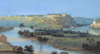
Fort Snelling is a former military fortification and National Historic Landmark in the U.S. state of Minnesota on the bluffs overlooking the confluence of the Minnesota and Mississippi Rivers. The military site was initially named Fort Saint Anthony, but it was renamed Fort Snelling once its construction was completed in 1825.

Prairie du Chien is a city in and the county seat of Crawford County, Wisconsin, United States. The population was 5,506 at the 2020 census. Its ZIP Code is 53821.

Jacques Marquette, S.J., sometimes known as Père Marquette or James Marquette, was a French Jesuit missionary who founded Michigan's first European settlement, Sault Sainte Marie, and later founded Saint Ignace. In 1673, Marquette, with Louis Jolliet, an explorer born near Quebec City, was the first European to explore and map the northern portion of the Mississippi River Valley.

Events from the year 1738 in Canada.

The history of the U.S. state of Minnesota is shaped by its original Native American residents, European exploration and settlement, and the emergence of industries made possible by the state's natural resources. Early economic growth was based on fur trading, logging, milling and farming, and later through railroads and iron mining.

The colony of Canada was a French colony within the larger territory of New France. It was claimed by France in 1535 during the second voyage of Jacques Cartier, in the name of the French king, Francis I. The colony remained a French territory until 1763, when it became a British colony known as the Province of Quebec.

The Archdiocese of Saint Paul and Minneapolis is a Latin Church ecclesiastical jurisdiction or diocese of the Catholic Church in the United States. It is led by an archbishop who administers the archdiocese from the cities of Saint Paul and Minneapolis. The archbishop has both a cathedral and co-cathedral: the mother church – the Cathedral of Saint Paul in Saint Paul, and the co-cathedral, the Basilica of Saint Mary in Minneapolis.

Lake Pepin is a naturally occurring lake on the Mississippi River on the border between the U.S. states of Minnesota and Wisconsin. It is located in a valley carved by the outflow of an enormous glacial lake at the end of the last Ice Age. The lake formed when the Mississippi, a successor to the glacial river, was partially dammed by a delta from a tributary stream and spread out across the ancient valley.

Old Crow Wing is a ghost town in Fort Ripley Township, Crow Wing County, Minnesota, United States, at the confluence of the Mississippi and Crow Wing rivers. Long occupied by the Ojibwe people, for over a century it was also the northernmost European-American settlement on the Mississippi.

This is a list of the National Register of Historic Places listings in Dakota County, Minnesota. It is intended to be a complete list of the properties and districts on the National Register of Historic Places in Dakota County, Minnesota, United States. Dakota County is located in the southeastern part of the U.S. state of Minnesota, bounded on the northeast side by the Upper Mississippi River and on the northwest by the Minnesota River. The locations of National Register properties and districts for which the latitude and longitude coordinates are included below, may be seen in an online map.

Saint Paul is the second largest city in the U.S. state of Minnesota, the county seat of Ramsey County, and the state capital of Minnesota. The origin and growth of the city were spurred by the proximity of Fort Snelling, the first major United States military installation in the area, as well as by the city's location on the northernmost navigable port of the Upper Mississippi River.

Lucien Galtier was the first Roman Catholic priest who served in Minnesota. He was born in southern France in the town of Saint-Affrique, department of Aveyron. The year of his birth is somewhat uncertain, some sources claiming 1811 but his tomb at Prairie du Chien, WI, bearing the date December 17, 1812. In the 1830s, people were settling across the Minnesota River from Fort Snelling in the area of Mendota, Minnesota. Mathias Loras, bishop of the Roman Catholic Diocese of Dubuque, Iowa learned of these settlers and journeyed up the Mississippi River to visit the settlers in the area. He wrote to his sister that "the Catholics of St. Peters amounted to one hundred and eighty five." The bishop saw a need to send a missionary to the area the next year. Galtier spoke little English when he arrived in 1840.

The Pays d'en Haut was a territory of New France covering the regions of North America located west of Montreal. The vast territory included most of the Great Lakes region, expanding west and south over time into the North American continent as the French had explored. The Pays d'en Haut was established in 1610 and dependent upon the colony of Canada until 1763, when the Treaty of Paris ended New France, and both were ceded to the British as the Province of Quebec.
L'Arbre Croche, known by the Odawa people as Waganagisi, was a large Odawa settlement in Northern Michigan. The French called it L'Arbre Croche for the large crooked tree that marked the center of the settlement and was visible for many miles. It covered the region from Harbor Springs to Cross Village in present-day Emmet County, Michigan.
The territorial era of Minnesota lasted from the Louisiana Purchase in 1803 to Minnesota's achieving statehood in 1858. The Minnesota Territory itself was formed only in 1849 but the area had a rich history well before this. Though there was a long history of European presence in the area before 19th century, it was during the 19th century that the United States began to establish a firm presence in what would become Minnesota.

West Seventh is a neighborhood in Saint Paul, Minnesota, United States. This area is colloquially known as the West End, and is not to be confused with the West Side, a different neighborhood. The West End lies at the base of Summit Hill and along the western bluffs of the Mississippi River, spanning the entire length of West Seventh Street, or Old Fort Road; it is also known as the Fort Road area. Fort Road was a historic Native American and fur trader path along the Mississippi River from downtown Saint Paul to Fort Snelling.
Fort Trempealeau was founded in 1685 by Nicholas Perrot and a groupe of Canadiens. In the fall of 1685, Perrot and his men arrived at Mont Trempealeau by canoe. The Winnebagos called this mountain, Hay-nee-ah-cheh, or the mountain in the water. That is why Perrot called it in French, la montagne qui trempe à l'eau, or Trempealeau mountain. There, Perrot and his men built a protective shelter in preparation for winter. Several weeks earlier they had left La Baye Green Bay and crossed Wisconsin via the Fox and Wisconsin Rivers to reach the Mississippi Valley. The purpose of this expedition was to establish alliances with the Ioway and Dakota Indians in order to expand French interests in the fur trade market. Although Perrot's venture was not the first French excursion into the upper Mississippi Valley, his was the first attempt to establish a foothold in this region. In the spring of 1686 the Trempealeau site was abandoned for a more advantageous location along Lake Pepin where Perrot built Fort Saint Antoine. Over the next thirty-five years French economic fortunes in the upper Mississippi Valley waxed and waned. It was not until 1731, and the end of the Fox Indian wars, that the French under the command of René Godefroy, sieur de Linctot returned to Trempealeau and established another trading post.
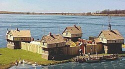
Fort Saint Antoine was a French fort on Lake Pepin in present-day Wisconsin founded in 1686 by explorer and fur trader Nicholas Perrot and his expedition of Canadiens. They had come to the region to begin trading with Native American tribes of the area.