Creve Coeur, Illinois

Last updated

Creve Coeur
Creve Coeur sign 20230923 0001.jpg
Creve Coeur sign located by the Veterans Memorial
Etymology: means "broken heart" in French
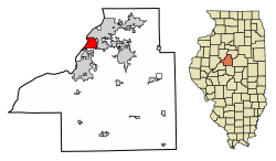
Tazewell County Illinois Incorporated and Unincorporated areas Creve Coeur Highlighted.svg
Location of Creve Coeur in Tazewell County, Illinois.
Illinois in United States (US48).svg
Location of Illinois in the United States
Coordinates: 40°38′34″N89°35′54″W / 40.64278°N 89.59833°W / 40.64278; -89.59833 [1]
CountryUnited States
StateIllinois
County Tazewell
Township Groveland
Government
[2]
  MayorFred Lang
Area
[3]
  Total4.55 sq mi (11.78 km2)
  Land4.23 sq mi (10.96 km2)
  Water0.32 sq mi (0.82 km2)
Elevation
[1]
663 ft (202 m)
Population
 (2020)
  Total4,934
  Density1,166.15/sq mi (450.26/km2)
Time zone UTC-6 (CST)
  Summer (DST) UTC-5 (CST)
Zip code
61610
Area code 309
FIPS code 17-17549
GNIS feature ID2398651 [1]
Wikimedia CommonsCreve Coeur, Illinois
Website www.villageofcc.com

Creve Coeur is a village in Groveland Township, Tazewell County, Illinois, United States. As of the 2020 census, the village population was 4,934. Creve Coeur is a suburb of Peoria and is part of the Peoria, Illinois Metropolitan Statistical Area.

Contents

Geography

According to the 2010 census, Creve Coeur has a total area of 4.675 square miles (12.11 km2), of which 4.31 square miles (11.16 km2) (or 92.19%) is land and 0.365 square miles (0.95 km2) (or 7.81%) is water. [4]

Demographics

Historical population
CensusPop.Note
1930 350
1940 3,535910.0%
1950 5,49955.6%
1960 6,68421.5%
1970 6,440−3.7%
1980 6,8516.4%
1990 5,938−13.3%
2000 5,448−8.3%
2010 5,4510.1%
2020 4,934−9.5%
U.S. Decennial Census [5]

At the 2000 census there were 5,448 people, 2,219 households, and 1,488 families in the village. The population density was 1,342.2 inhabitants per square mile (518.2/km2). There were 2,476 housing units at an average density of 610.0 per square mile (235.5/km2). The racial makeup of the village was 97.14% White, 0.39% African American, 0.53% Native American, 0.18% Asian, 0.02% Pacific Islander, 0.81% from other races, and 0.94% from two or more races. Hispanic or Latino of any race were 1.95%. [6]

Of the 2,219 households 28.8% had children under the age of 18 living with them, 50.2% were married couples living together, 12.2% had a female householder with no husband present, and 32.9% were non-families. 27.2% of households were one person and 9.8% were one person aged 65 or older. The average household size was 2.46 and the average family size was 2.97.

The age distribution was 24.7% under the age of 18, 8.9% from 18 to 24, 30.5% from 25 to 44, 22.6% from 45 to 64, and 13.3% 65 or older. The median age was 36 years. For every 100 females, there were 97.9 males. For every 100 females age 18 and over, there were 95.2 males.

The median household income was $36,138 and the median family income was $41,006. Males had a median income of $32,188 versus $21,302 for females. The per capita income for the village was $16,712. About 4.5% of families and 7.3% of the population were below the poverty line, including 7.6% of those under age 18 and 5.5% of those age 65 or over.

Transportation

CityLink provides bus service on Route 29 connecting Creve Coeur to downtown Peoria, downtown Pekin and other destinations. [7]

See also

Related Research Articles

<span class="mw-page-title-main">Bureau Junction, Illinois</span> Village in Illinois, United States

Bureau Junction, usually called Bureau, is a village in Bureau County, Illinois, United States. The population was 281 at the 2020 census. The village name is shown as both "Bureau Junction" and "Bureau" on federal maps, and is commonly called "Bureau", including by phone companies and the United States Post Office. It is part of the Ottawa Micropolitan Statistical Area. Bureau Junction was the point where the Rock Island Line railroad's branch line to Peoria split. Track west and south of Bureau is operated by Iowa Interstate, while tracks east to Chicago were formerly operated by CSX but are currently leased to Iowa Interstate.

<span class="mw-page-title-main">Hindsboro, Illinois</span> Village in Illinois, United States

Hindsboro is a village in Douglas County, Illinois, United States. The population was 275 at the 2020 census.

<span class="mw-page-title-main">Banner, Illinois</span> Village in Illinois, United States

Banner is a village in Fulton County, Illinois, United States. The population was 169 at the 2020 census.

<span class="mw-page-title-main">Liverpool, Illinois</span> Village in Illinois, United States

Liverpool is a village in Fulton County, Illinois, United States. The population was 94 at the 2010 census.

<span class="mw-page-title-main">Smithfield, Illinois</span> Village in Illinois, United States

Smithfield is a village in Fulton County, Illinois, United States. The population was 191 at the 2020 census. The village is named in honor of Dr. Joseph N. Smith.

<span class="mw-page-title-main">East Galesburg, Illinois</span> Village in Illinois, United States

East Galesburg is a village in Knox County, Illinois, United States. The population was 812 as of the 2010 census, down from 839 in 2000. It is part of the Galesburg Micropolitan Statistical Area.

<span class="mw-page-title-main">La Rose, Illinois</span> Village in Illinois, United States

La Rose is a village in Bell Plain Township, Marshall County, Illinois, United States. The population was 98 at the 2020 census, down from 144 in 2010. It is part of the Peoria Metropolitan Statistical Area.

<span class="mw-page-title-main">Washburn, Illinois</span> Village in Illinois, United States

Washburn is a village mostly in Woodford County, with a small northerly portion in Marshall County, Illinois, United States. The population was 1,032 at the 2020 census. It is part of the Peoria Metropolitan Statistical Area.

<span class="mw-page-title-main">Bartonville, Illinois</span> Village in Illinois, United States

Bartonville is a village in Peoria County, Illinois, United States. The population was 6,471 at the 2010 census. Bartonville is a suburb of Peoria and is part of the Peoria, Illinois Metropolitan Statistical Area.

<span class="mw-page-title-main">Bellevue, Illinois</span> Village in Illinois, United States

Bellevue is a village in Peoria County, Illinois, United States. The population was 1,978 at the 2010 census. Bellevue is a suburb of Peoria and is part of the Peoria, Illinois Metropolitan Statistical Area.

<span class="mw-page-title-main">Hanna City, Illinois</span> Village in Illinois, United States

Hanna City is a village in Peoria County, Illinois, United States. The population was 1,225 at the 2010 census. Hanna City is part of the Peoria Metropolitan Statistical Area.

<span class="mw-page-title-main">Kingston Mines, Illinois</span> Village in Illinois, United States

Kingston Mines is a village in Peoria County, Illinois, United States. The population was 259 at the 2000 census. It is part of the Peoria, Illinois Metropolitan Statistical Area. Located on the Illinois River, it was a shipping port, loading coal from the nearby mines.

<span class="mw-page-title-main">Mapleton, Illinois</span> Village in Illinois, United States

Mapleton is a small village in Peoria County, Illinois, United States. The population was 227 at the 2000 census. Mapleton is part of the Peoria, Illinois Metropolitan Statistical Area. There are four different plants in Mapleton, all located along U.S. Route 24: an Evonik chemical plant, a Lonza Group plant, a Caterpillar Inc. foundry, and an Ingredion facility; together, the large industrial complex forms one of Mapleton's most significant employers and a good source of skilled employees and good jobs.

<span class="mw-page-title-main">Norwood, Illinois</span> Village in Illinois, United States

Norwood is a village in Peoria County, Illinois, United States. The population was 478 at the 2010 census. Norwood, just outside Peoria, is part of the Peoria, Illinois Metropolitan Statistical Area.

<span class="mw-page-title-main">Princeville, Illinois</span> Village in Illinois, United States

Princeville is a village in Peoria County, Illinois, United States. The population was 1,738 at the 2010 census, up from 1,621 in 2000. It is part of the Peoria, Illinois Metropolitan Statistical Area.

Rome is a census-designated place (CDP) in Medina Township, Peoria County, Illinois, United States. The population of the CDP was 1,738 at the 2010 census. Rome is part of the Peoria, Illinois Metropolitan Statistical Area.

<span class="mw-page-title-main">Minier, Illinois</span> Village in Illinois, United States

Minier is a village in Tazewell County, Illinois, United States. The population was 1,154 at the 2020 census. Minier is part of the Peoria, Illinois Metropolitan Statistical Area.

<span class="mw-page-title-main">Morton, Illinois</span> Village in Illinois, United States

Morton is a village in Tazewell County, Illinois, United States. The population was 17,117 at the 2020 census. Morton is a suburb of Peoria, located southeast of Peoria, and is part of the Peoria Metropolitan Statistical Area. The community holds a yearly Morton Pumpkin Festival for four days every September, and claims that "99 percent of the world's canned pumpkin is produced in Morton," earning it the designation "Pumpkin Capital of the World".

<span class="mw-page-title-main">North Pekin, Illinois</span> Village in Illinois, United States

North Pekin is a village in Tazewell County, Illinois, United States. The population was 1,573 at the 2010 census. North Pekin is a suburb of Peoria and is part of the Peoria, Illinois Metropolitan Statistical Area.

<span class="mw-page-title-main">Creve Coeur, Missouri</span> City in Missouri, United States

Creve Coeur is a city located in mid St. Louis County, Missouri, United States, a part of Greater St. Louis. Its population was 18,834 at the 2020 census. Creve Coeur borders and shares a ZIP code (63141) with the neighboring city of Town and Country. It is home to the headquarters of Drury Hotels, and was the home of Monsanto until its acquisition by Bayer in 2018.

References

  1. 1 2 3 U.S. Geological Survey Geographic Names Information System: Creve Coeur, Illinois
  2. "Mayor's Office - Village of Creve Coeur". Village of Creve Coeur. Retrieved September 12, 2024.
  3. "2020 U.S. Gazetteer Files". United States Census Bureau. Retrieved March 15, 2022.
  4. "G001 - Geographic Identifiers - 2010 Census Summary File 1". United States Census Bureau. Archived from the original on February 13, 2020. Retrieved August 2, 2015.
  5. "Census of Population and Housing". Census.gov. Retrieved June 4, 2015.
  6. "U.S. Census website". United States Census Bureau . Retrieved January 31, 2008.
  7. "Schedules & Routes" . Retrieved January 27, 2024.