Armington, Illinois

Last updated

Armington
Tazewell County Illinois Incorporated and Unincorporated areas Armington Highlighted.svg
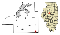
Location of Armington in Tazewell County, Illinois.
Illinois in United States (US48).svg
Location of Illinois in the United States
Coordinates: 40°20′23″N89°18′52″W / 40.33972°N 89.31444°W / 40.33972; -89.31444 [1]
CountryUnited States
StateIllinois
County Tazewell
Area
[2]
  Total0.28 sq mi (0.74 km2)
  Land0.28 sq mi (0.74 km2)
  Water0.00 sq mi (0.00 km2)
Elevation
[1]
627 ft (191 m)
Population
 (2020)
  Total310
  Density1,087.72/sq mi (420.19/km2)
Time zone UTC-6 (CST)
  Summer (DST) UTC-5 (CDT)
ZIP Code(s)
61721
Area code 309
FIPS code 17-02206
GNIS feature ID2397988 [1]
Wikimedia CommonsArmington, Illinois

Armington is a village in Tazewell County, Illinois, United States. The population was 368 at the 2000 census. It is part of the Peoria, Illinois Metropolitan Statistical Area.

Contents

Geography

According to the 2010 census, Armington has a total area of 0.29 square miles (0.75 km2), all land. [3]

Demographics

Historical population
CensusPop.Note
1880 129
1890 24186.8%
1910 327
1920 36812.5%
1930 315−14.4%
1940 299−5.1%
1950 3145.0%
1960 3274.1%
1970 36812.5%
1980 297−19.3%
1990 34817.2%
2000 3685.7%
2010 343−6.8%
2020 310−9.6%
U.S. Decennial Census [4]

As of the census [5] of 2000, there were 368 people, 135 households, and 98 families residing in the village. The population density was 1,283.7 inhabitants per square mile (495.6/km2). There were 152 housing units at an average density of 530.2 per square mile (204.7/km2). The racial makeup of the village was 99.46% White, and 0.54% from two or more races. Hispanic or Latino of any race were 2.72% of the population.

There were 135 households, out of which 39.3% had children under the age of 18 living with them, 65.2% were married couples living together, 6.7% had a female householder with no husband present, and 26.7% were non-families. 25.2% of all households were made up of individuals, and 11.9% had someone living alone who was 65 years of age or older. The average household size was 2.73 and the average family size was 3.27.

In the village, the population was spread out, with 34.0% under the age of 18, 3.0% from 18 to 24, 33.4% from 25 to 44, 20.4% from 45 to 64, and 9.2% who were 65 years of age or older. The median age was 33 years. For every 100 females, there were 102.2 males. For every 100 females age 18 and over, there were 96.0 males.

The median income for a household in the village was $39,583, and the median income for a family was $47,708. Males had a median income of $39,306 versus $24,167 for females. The per capita income for the village was $17,866. About 3.1% of families and 8.0% of the population were below the poverty line, including 10.3% of those under age 18 and 5.3% of those age 65 or over.

Related Research Articles

<span class="mw-page-title-main">Farina, Illinois</span> Village in Illinois, United States

Farina is a village in Fayette and Marion counties, Illinois, United States. The population was 540 at the 2020 census. It is the only community with the name "Farina" in the United States.

<span class="mw-page-title-main">Stronghurst, Illinois</span> Village in Illinois, United States

Stronghurst is a village in Henderson County, Illinois, United States. The population was 833 at the 2020 census. It is part of the Burlington, IA–IL Micropolitan Statistical Area.

<span class="mw-page-title-main">Wellington, Illinois</span> Village in Illinois, United States

Wellington is a village in Lovejoy Township, Iroquois County, Illinois, United States. The population was 242 at the 2010 census.

<span class="mw-page-title-main">Island Lake, Illinois</span> Village in Illinois, United States

Island Lake is a village in Lake and McHenry counties in the U.S. state of Illinois. Per the 2020 census, the population was 8,051. The village surrounds Island Lake, a lake which contains a small island.

<span class="mw-page-title-main">Russellville, Illinois</span> Village in Illinois, United States

Russellville is a village in Lawrence County, Illinois, United States. The population was 94 at the 2010 census.

<span class="mw-page-title-main">Standard City, Illinois</span> Village in Illinois, United States

Standard City is a village in Macoupin County, Illinois, United States. The population was 135 at the 2020 census.

<span class="mw-page-title-main">South Roxana, Illinois</span> Village in Illinois, United States

South Roxana, incorporated in March 1967, is a village in Madison County, Illinois, United States. The population was 1,891 at the 2020 census.

<span class="mw-page-title-main">Wenonah, Illinois</span> Village in Illinois, United States

Wenonah is a small village in Montgomery County, Illinois, United States. The population was 32 at the 2020 census.

<span class="mw-page-title-main">Tilden, Illinois</span> Village in Illinois, United States

Tilden is a village in Randolph County, Illinois, United States. The population was 934 at the 2010 census.

<span class="mw-page-title-main">Findlay, Illinois</span> Village in Illinois, United States

Findlay is a village in Shelby County, Illinois, United States. The population was 664 at the 2020 census.

<span class="mw-page-title-main">East Carondelet, Illinois</span> Village in Illinois, United States

East Carondelet is a village in St. Clair County, Illinois, United States. The population was 499 as of the 2010 census.

<span class="mw-page-title-main">Elkton, Michigan</span> Village in Michigan, United States

Elkton is a village in Huron County in the U.S. state of Michigan. The population was 796 at the 2020 census. The village is within Oliver Township, along the Pinnebog River. It was incorporated in 1897.

<span class="mw-page-title-main">Hillsdale, Missouri</span> Village in Missouri, United States

Hillsdale is a village in St. Louis County, Missouri, United States. Greenwood Cemetery is located in Hillsdale. The population was 1,478 at the 2010 census.

<span class="mw-page-title-main">Bloomingburg, Ohio</span> Village in Ohio, United States

Bloomingburg is a village in Fayette County, Ohio, United States. The population was 878 at the 2020 census.

<span class="mw-page-title-main">Monroeville, Ohio</span> Village in Ohio, United States

Monroeville is a village in Huron County, Ohio, United States. The population was 1,300 at the 2020 census.

<span class="mw-page-title-main">Farmersville, Ohio</span> Village in Ohio, United States

Farmersville is a village in Jackson Township, Montgomery County, Ohio, United States. The population was 975 at the 2020 census. It is part of the Dayton Metropolitan Statistical Area.

<span class="mw-page-title-main">Macksburg, Ohio</span> Village in Ohio, United States

Macksburg is a village in Washington County, Ohio, United States, along the West Fork of Duck Creek. The population was 120 at the 2020 census. The village is about 28 miles (45 km) south of Cambridge, Ohio.

<span class="mw-page-title-main">Unity, Wisconsin</span> Village in Wisconsin, United States

Unity is a village in Clark and Marathon counties in the U.S. state of Wisconsin. It is part of the Wausau, Wisconsin Metropolitan Statistical Area. The population was 343 at the 2010 census. Of this, 204 were in Marathon County, and 139 were in Clark County. The village is located in northeastern town of Unity in Clark County and northwestern town of Brighton in Marathon County.

<span class="mw-page-title-main">Lowell, Wisconsin</span> Village in Wisconsin, United States

Lowell is a village in Dodge County, Wisconsin, United States, along the Beaver Dam River. The population was 340 at the 2010 census. The village is located within the Town of Lowell.

<span class="mw-page-title-main">Westfield Township, Bureau County, Illinois</span> Township in Illinois, United States

Westfield Township is one of twenty-five townships in Bureau County, Illinois, USA. As of the 2020 census, its population was 874 and it contained 421 housing units.

References

  1. 1 2 3 U.S. Geological Survey Geographic Names Information System: Armington, Illinois
  2. "2020 U.S. Gazetteer Files". United States Census Bureau. Retrieved March 15, 2022.
  3. "G001 - Geographic Identifiers - 2010 Census Summary File 1". United States Census Bureau. Archived from the original on February 13, 2020. Retrieved August 1, 2015.
  4. "Census of Population and Housing". Census.gov. Retrieved June 4, 2015.
  5. "U.S. Census website". United States Census Bureau . Retrieved January 31, 2008.