After the United States Army outlawed alcohol trading in 1869 with the Blood nation in Montana, traders John J. Healy and Alfred B. Hamilton started the whisky trading post Fort Hamilton[3] near the junction of the St. Mary and Oldman rivers.[2][4] It was burned down, but they rebuilt it and eventually it came to be nicknamed Fort Whoop-Up.[5] The whisky traded at this post was often not much more than alcohol, river water, chewing tobacco and lye.
The whisky trade eventually led to the massacre of many Assiniboines in the Cypress Hills area by some Americans in 1873. As a result, the North-West Mounted Police (now the RCMP) were established, and a contingent travelled to southern Alberta to stop the trade and establish order.[6][7] The NWMP arrived at Fort Whoop-Up on 9 October 1874.[8] Later in 1875, the NWMP established a post at Fort Whoop-up by renting a room from Healy and Hamilton. For the next twelve years, the fort continued to trade (although not in "whisky") while also hosting a NWMP post.
Coal mining
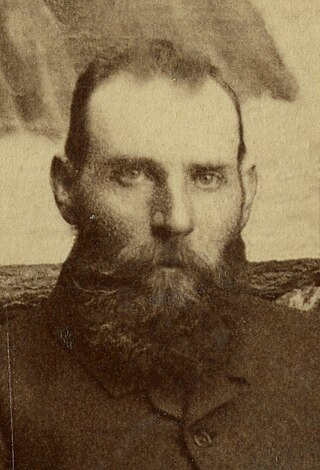
By the 1870s, Nicholas Sheran (an American entrepreneur) mined a coal seam in the coulees on the west side of what is now the Oldman River. He sold what he mined to Montana traders and the NWMP.[2][9]
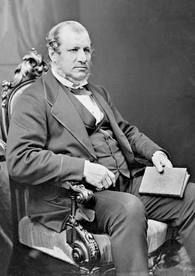
Sir Alexander Tilloch Galt was interested in the success Sheran was having. He knew a transcontinental railway was soon to be built in the area,[10] and the settlers it would bring would create a profitable market for the coal.[2][9]
By the start of the 20th century, the mines employed about 150 men and produced about 300 tonnes of coal each day.[2] By the time production peaked during World War I, 10 mines employed 2,000 miners and produced 1 million tonnes of coal annually. At the time, Lethbridge area collieries were the largest coal producers in the Northwest Territories.[13]
After the war, an increase in oil and natural gas production caused a decline in coal production,[2] and the last mine in Lethbridge closed in 1957. Some of this mine, Galt No. 8, still stands today, and a local society is attempting to renovate it as a museum or interpretive centre.
Rail
Immigrants arrive at Lethbridge station in 1953. Passenger rail service continued to the city until 1971.
The first rail line was built in Lethbridge, being completed 28 August 1885 by the Alberta Railway and Coal Company. The line was further extended 595 kilometres beyond Lethbridge and was instrumental in feeding the main CPR lines at the time the ARCC sold it to the CPR in 1912. Because of the rail industry's dependence of coal and the CPR's efforts to settle immigrants in southern Alberta, the railway centre of Lethbridge was instrumental in the economic success of the region.[14] In the mid-1980s, the railyards in downtown Lethbridge were moved to nearby Kipp and Lethbridge ceased operating as a hub for rail traffic.
Riot of 1907
On 25 December 1907, an altercation occurred at the Dallas Hotel (now the Coalbanks Inn) on 5 Street South in downtown Lethbridge. Reportedly, the altercation was between a Chinese employee working the hotel's restaurant and a Caucasian customer.
Word of the altercation spread and somehow escalated into rumours the employee had killed the customer. As a result, a large crowd gathered at the hotel and ransacked the restaurant. Shortly after, they moved to nearby Chinatown to wreak havoc there.
At this point, the local police gathered to control the situation and mayor W. S. Galbraith read the Riot Act to those gathered. As a result, everything was brought under control and the crowd soon dispersed.[15]
After the CPR moved the divisional point of its Crowsnest Line from Fort Macleod to Lethbridge in 1905, the city became a regional centre for Southern Alberta; something the region did not have previously.[2] Between 1907 and 1913, a development boom occurred in Lethbridge, making it the main marketing, distribution and service centre in southern Alberta.[2] Several municipal projects, a construction boom, and rising real estate prices transformed the mining town into a significant city.[2]
Part of the impetus behind the municipal projects above was the city playing host to the 7th International Dry-Farming Congress in 1912. As recently as 1911, the city had no facilities to host an event of this significance. By the time the event arrived in October, the city had spent $1.35 million paving downtown streets, putting in cement sidewalks, improving the water and sewer systems, building a street railcar system, creating Henderson Park and setting aside 60 acres (24ha) for the Exhibition Grounds. Despite the event attracting thousands of delegates from throughout Canada and such places as China, Italy, and India, the city's tax base of only 8,000 could not support those improvements. The city carried the debt for decades after. Even so, the Lethbridge Herald labelled the event as "the greatest week in the history of the city".[16]
Between World War I and World War II, the city experienced an economic slump. Development slowed, drought drove farmers from their farms and coal mining rapidly declined from its peak before 1920.[2] Following WWII, irrigation in the surrounding area caused the city's population to swell, which in turn boosted the local economy. Lethbridge Community College (now Lethbridge College) opened in April 1957, and the University of Lethbridge in 1967.[2]
Before settlement, the area where Lethbridge is located was known as The Arid Region. After geological surveys around 1880 revealed an abundance of coal, it became called The Belly River Coal District. After the Galts introduced irrigation to counter the Arid Region problems around 1900, the locality became called the Irrigated District. Finally, as an aid to land sales after the rush of dryland settlement started about 1905, the non-irrigable portion was called The Winter Wheat Lands.
Since October 15, 1885, the name Lethbridge has been the official term.[14] The name Lethbridge was in common unofficial use for the river bottom community at least as early as May 1884.
↑ Johnston, Alex (1969). "Southern Alberta's Whiskey Trade". Lethbridge: Research Station, Canada Department of Agriculture: 5. Retrieved 9 September 2009.{{cite journal}}: Cite journal requires |journal= (help)
↑ Johnston, Alex; den Otter, Andy A. (1985). "Lethbridge: A Centennial History". Lethbridge: The City of Lethbridge and The Whoop-Up Country Chapter, Historical Society of Alberta: 32. Retrieved 9 September 2009.{{cite journal}}: Cite journal requires |journal= (help)
↑ Johnston, Alex (1969). "Southern Alberta's Whiskey Trade". Lethbridge: Research Station, Canada Department of Agriculture: 9. Retrieved 9 September 2009.{{cite journal}}: Cite journal requires |journal= (help)
↑ Johnston, Alex (1969). "Southern Alberta's Whiskey Trade". Lethbridge: Research Station, Canada Department of Agriculture: 6. Retrieved 9 September 2009.{{cite journal}}: Cite journal requires |journal= (help)
↑ Johnston, Alex; den Otter, Andy A. (1985). "Lethbridge: A Centennial History". Lethbridge: The City of Lethbridge and The Whoop-Up Country Chapter, Historical Society of Alberta: 33. Retrieved 11 September 2009.{{cite journal}}: Cite journal requires |journal= (help)
↑ Johnston, Alex (1969). "Southern Alberta's Whiskey Trade". Lethbridge: Research Station, Canada Department of Agriculture: 7. Retrieved 9 September 2009.{{cite journal}}: Cite journal requires |journal= (help)
1 2 Johnston, Alex; den Otter, Andy A. (1985). "Lethbridge: A Centennial History". Lethbridge: The City of Lethbridge and The Whoop-Up Country Chapter, Historical Society of Alberta: 37. Retrieved 11 September 2009.{{cite journal}}: Cite journal requires |journal= (help)
↑ Johnston, Alex; den Otter, Alex A. (1985). "Lethbridge: A Centennial History". Lethbridge: The City of Lethbridge and The Whoop-Up Country Chapter, Historical Society of Alberta: 38. Retrieved 11 September 2009.{{cite journal}}: Cite journal requires |journal= (help)
1 2 Johnston, Alex; den Otter, Andy A. (1985). "Lethbridge: A Centennial History". Lethbridge: The City of Lethbridge and The Whoop-Up Country Chapter, Historical Society of Alberta: 40. Retrieved 14 September 2009.{{cite journal}}: Cite journal requires |journal= (help)
Sir Alexander Tilloch Galt, was a politician and Founding Father of the Canadian Confederation.
Lethbridge is a city in the province of Alberta, Canada, on the lands of the Blackfoot people and home to the Métis Nation of Alberta, Region 3. With a population of 106,550 in the 2023 municipal census. Lethbridge became the fourth Alberta city to surpass 100,000 people. The nearby Canadian Rocky Mountains contribute to the city's warm summers, mild winters, and windy climate. Lethbridge lies southeast of Calgary on the Oldman River.
Fort Calgary was a North-West Mounted Police outpost at the confluence of the Bow and Elbow rivers in present-day Calgary, Alberta, Canada. Originally named Fort Brisebois, after the outpost's first commander, the outpost was renamed Fort Calgary in June 1876.
Fort Whoop-Up was the nickname given to a whisky trading post, originally Fort Hamilton, near what is now Lethbridge, Alberta. During the late 19th century, the post served as a centre for trading activities, including the illegal whisky trade. The sale of whisky was outlawed but, due to the lack of law enforcement in the region prior to 1874, many whisky traders had settled in the area and taken to charging unusually high prices for their goods.
Montague Aldous was a Dominion Topographical Surveyor from Charlottetown, Prince Edward Island. He was a participant in foundation surveys of the Northwest Territories. He was associated with A.L. Russell in 1877 in a survey west to the third meridian. Taken on Special Survey in 1879, he surveyed the fourth meridian to a point north of Lloydminster, Alberta/Saskatchewan, then ran in the 14th base line west to Stony Plain where it intersected the 5th meridian. His assistant, Charles Alexander Magrath, was later the first mayor of Lethbridge, Northwest Territories. In 1880 Aldous surveyed the fifth meridian south to Waterton Lakes. He spent the rest of the summer in southern Alberta's Porcupine Hills, then being taken up for ranching.
Stirling is a village in southern Alberta, Canada that is surrounded by the County of Warner No. 5. The village is located on Highway 4, approximately 31 km (19 mi) southeast of Lethbridge and 72 km (45 mi) northwest of the Canada–US border.
Alberta Provincial Highway No. 4, commonly referred to as Highway 4, is a 103-kilometre (64 mi) highway in southern Alberta, Canada that connects Highway 3 in Lethbridge to Interstate 15 in Montana. The highway was designated in 1999 as the First Special Service Force Memorial Highway in honour of elite soldiers who travelled to Helena, Montana for training before World War II. The highway continues into the United States retaining that name.
Nicholas Sheran (1841–1882) was an entrepreneur born in New York City. He spent his early years apprenticing as a printer, working on Arctic whalers, and serving in the United States Army.
There are many forms of transport in Lethbridge, Alberta, Canada, including highways and public transit. Lethbridge's airport is Lethbridge Airport (YQL), which is south of the city boundary. Lethbridge also has an intricate cycling-and-pedestrian pathway that meets several destinations in the city, including the urban park system in the Oldman River valley.
Downtown Lethbridge is the central business district of Lethbridge, Alberta, Canada, hosting most of the city's banks and several accounting and law practices, including national firms.
Galt Museum & Archives is the primary museum in Lethbridge, Alberta, Canada, and is the largest museum in the province south of Calgary. In 2006, the museum cared for a growing collection of over 20,000 artifacts and 300,000 archival documents and photographs record the history of Lethbridge and southern Alberta. It attracts over 50,000 visitors every year.
The flag of Lethbridge is the official flag of Lethbridge, Alberta, and was designed in 1967, the year of Canada's centennial. It is based on the flag that was once flown at Fort Whoop-Up.
The March West was the initial journey of the North-West Mounted Police (NWMP) to the Canadian prairies, made between July 8 and October 9, 1874.
The Red Coat Trail is a 1,300-kilometre (810 mi) route that approximates the path taken in 1874 by the North-West Mounted Police in their March West from Fort Dufferin to Fort Whoop-Up.
The Rocky Springs Segment of the Whoop-Up Trail was the location of campsites for travellers along the Whoop-Up Trail between Fort Benton, Montana and Fort Hamilton, Alberta in the 19th century. In 1991, it was the best-preserved segment of the Whoop-Up Trail within Montana and it included rut tracks still visible and the surrounding landscape was mostly natural. The numerous small springs in the area were mostly dried up by 1991 "due to modern cultivation and resultant ground water changes". It was listed on the National Register of Historic Places in 1993.
The following is a bibliography of Alberta history.
Staffordville, also originally known as Stafford, is a residential neighbourhood in Lethbridge, Alberta, Canada that held village status between 1900 and 1913.
William Stafford was a coal mining engineer and mine superintendent for the North Western Coal and Navigation Company who was responsible for determining the location of the City of Lethbridge, Alberta, Canada.
Coal in Alberta is found in the Coalspur Formation in the Western Canada Sedimentary Basin in the foothills of southwestern Alberta. The Coalspur Formation, which has large quantities of high-quality coal, runs from south of the Wapiti River to the North Saskatchewan River. The Coalspur coal zone is about 120 metres (390 ft) to 200 metres (660 ft) thick.
This page is based on this Wikipedia article Text is available under the CC BY-SA 4.0 license; additional terms may apply. Images, videos and audio are available under their respective licenses.