A number of states and polities formerly claimed colonies and territories in Canada prior to the evolution of the current provinces and territories under the federal system.[1]North America prior to colonization was occupied by a variety of indigenous groups consisting of band societies typical of the sparsely populated North, to loose confederacies made up of numerous hunting bands from a variety of ethnic groups (Plains region), to more structured confederacies of sedentary farming villages (Great Lakes region), to stratified hereditary structures centred on a fishing economy (Plateau and Pacific Coast regions).[2] The colonization of Canada by Europeans began in the 10th century, when Norsemen explored and, ultimately unsuccessfully, attempted to settle areas of the northeastern fringes of North America.[3] Early permanent European settlements in what is now Canada included the late 16th and 17th century French colonies of Acadia and Canada (New France),[4] the English colonies of Newfoundland and Rupert's Land,[5] the Scottish colonies of Nova Scotia and Port Royal.[6]
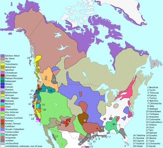
Pre-Columbian distribution of North American language families
Indigenous peoples in what is now Canada did not form state societies and, in the absence of state structures, academics usually classify indigenous people by their traditional "lifeway" (or primary economic activity) and ecological/climatic region into "culture areas", or by their language families.[10]
While the Norse colonies in Greenland lasted for almost 500 years, the continental North American settlements were small and did not develop into permanent colonies.[18]Vinland, Markland and Helluland are the names given to three lands, possibly in Canada, discovered by Norsemen as described in the Eiríks saga rauða[19] and Grœnlendinga saga.[20]
Based on the Treaty of Tordesillas the Portuguese Crown claimed it had territorial rights in the Atlantic waters visited by explorer John Cabot in 1497 and 1498.[22] In 1498 to 1500, the Portuguese mariner João Fernandes Lavrador visited the north Atlantic coast, accounting for the appearance of the name "Labrador" on topographical maps of the period.[23] In 1501 and 1502, Miguel and Gaspar Corte-Real explored present day Newfoundland, claiming the land in the name of Portuguese Empire.[24] The extent and nature of Portuguese activity on the Canadian mainland during the 16th century remains unclear and controversial, but it is generally accepted that explorer Joao Álvarez Fagundes attempted to establish a seasonal fishing colony. It is not known exactly where and for how long the fishing post existed,[24][25] Nevertheless both the Portuguese and Spanish fishing industry in the area was destroyed in 1585 by an English expedition led by Bernard Drake, and never recovered.[26]
New France
Map of North America in 1750, before the French and Indian War, the North American theatre of the worldwide conflict known as the Seven Years' War (1756 to 1763), showing possessions of Britain (pink and purple), France (blue), and Spain (orange).
In 1534, Jacques Cartier planted a cross in the Gaspé Peninsula and claimed the land in the name of Francis I of France.[27] In 1600, a trading post was established at Tadoussac, but only five of the sixteen settlers survived the winter and returned home that summer.[27] In 1604, the first year-round permanent settlement was founded by Samuel de Champlain at Île-Saint-Croix on Baie Française (Bay of Fundy), which was moved to Port-Royal in 1605.[28] In 1608, Samuel de Champlain founded the city of Québec with 28 men of whom 20 died from lack of food and from scurvy the first winter.[28][29]
Animated map of North America's territorial evolution from 1750 to 2008 — in the interactive SVG version on a compatible browser, hover over the timeline to step through time
In 1799, Tsar Paul I proclaimed Russian title and established the Russian American Company's trade monopoly and rule in the North Pacific through the creation of Russian America.[36] The stated southward limit of Russian claims was 51 degrees north latitude, roughly that of Cape Scott at the northern tip of Vancouver Island.[37] Though no Russian settlements were established in what is now British Columbia, Russian trade and scientific expeditions frequented the North Coast. Intense tripartite negotiation led to treaties between Russia with the U.S. and Britain in 1824 and 1825, respectively, setting the new southward limit of Russian territories at 54 degrees, 40 minutes north latitude, corresponding with Cape Muzon at the southern tip of Dall Island, at the extreme southwest of what is today the Alaska Panhandle.[38][39]
Established in 1614 by the Dutch West India Company, the colony of New Netherland covered most of what is now New York State. It was created to give the Dutch access to the North American fur trade, and was governed from New Amsterdam (now New York City). The territory officially claimed by the Dutch extended as far north as the St. Lawrence River, placing much of their territory in modern-day Quebec. Despite the fact that no settlements were established in the area of Quebec, it was still officially part of New Netherland and thus a part of the Dutch Empire. In addition to that, during the Franco-Dutch wars of the 1670s, the Dutch captured several forts in Acadia, proclaiming the territory New Holland. There was no extensive settlement in the area, but the Dutch claims persisted for a few years at the least.
Animation of the evolution of the borders and names of Canada's provinces and territories
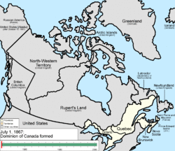
Canada became a semi-independent federated grouping of provinces and a dominion after the Constitution Act, 1867 (formerly called the British North America Act 1867).[9] Originally three provinces of British North America, New Brunswick, Nova Scotia and the Province of Canada (which would become Ontario and Quebec) united to form the new nation.[9] Full independence came with the Statute of Westminster 1931 and the Canada Act 1982. Since 1867, Canada's external borders have changed several times, and had grown from four initial provinces to ten provinces and three territories by 1999.[9] Territorial evolution included the use of Numbered Treaties.
The Alaska boundary dispute, simmering since the Alaska Purchase of 1867, became critical when gold was discovered in Yukon during the late 1890s and Canada wanted its own Pacific port connected to the gold fields.[40] Canada argued its historic boundary with Russian America included the Lynn Canal and the port of Skagway, both occupied by the U.S.,[40] while the U.S. claimed the Atlin District and the lower Stikine and even Whitehorse. The dispute went to arbitration in 1903, with the American claims largely upheld as the British delegate sided with the Americans to preserve the British interest in a close relationship with the U.S.[41]
Otto Sverdrup, a Norwegian explorer, claimed the Sverdrup Islands for Norway in 1902 but the Norwegian government showed no interest in pursuing the claim until 1928.[42] On 11 November 1930 (Remembrance Day) after formal Canadian intervention, Norway recognized Canada's sovereignty over the islands.[43]
Hans Island is the smallest of three islands located in Kennedy Channel; the others are Franklin Island and Crozier Island.[44] The island is the traditional hunting grounds of the Inuit and is claimed by both Canada and Denmark.[44] In 2007, updates of satellite photos led Canada to recognize the international border as crossing through the middle of Hans Island, not to the east of the island as previously claimed.[45]
Although Canada and the United States share the longest non-militarized border between two countries, there is a long history of disputes about the border's demarcation.[48]
Since Confederation in 1867, there have been several proposals for new Canadian provinces and territories. The Constitution of Canada requires an amendment for the creation of a new province[49] but the creation of a new territory requires only an act of Parliament;[50] therefore, it is easier legislatively to create a territory than a province.
↑The allied tribes occupied the territory which the French named Acadia. The tribes ranged from present-day northern and eastern New England in the United States to the Maritime Provinces of Canada. At the time of contact with the French (late 16th century), they were expanding from their maritime base westward along the Gaspé Peninsula/St. Lawrence River at the expense of Iroquoian-speaking tribes. The Míkmaq name for this peninsula was Kespek (meaning "last-acquired").
↑They can each be called "tribes" but the Blackfoot as a whole are also referred to as a "tribe" reflecting the inconsistent usage of that term.
Citations
↑"Eras". Canada History. 2009. Archived from the original on 22 October 2011.
↑Reeves, Arthur Middleton (2009). The Norse Discovery of America. Bibliophileċċ. p.191.
↑"French Colonies". Ashley Araiza, Cevera Clark, & Donielle Wolfe. Harlingen School District. 2009. Archived from the original on 1 May 2010. Retrieved 22 June 2010.
↑"Wabanaki". Wabanaki. 2014. Archived from the original on 6 November 2016. Retrieved 28 February 2014.
↑"Background 1: Ojibwa history". Department of Science and Technology Studies · The Center for Cultural Design. 2003. Archived from the original on 31 August 2011. Retrieved 15 April 2010.
↑J. Sephton, (English, translation) (1880). "The Saga of Erik the Red". Icelandic Saga Database. Retrieved 11 August 2010.{{cite web}}: CS1 maint: multiple names: authors list (link)
↑"Vikings: The North Atlantic Saga". National Museum of Natural History, Arctic Studies Center- (Smithsonian Institution). 2008. Archived from the original on 24 December 2015. Retrieved 11 August 2010.
↑Carnaghan, Matthew; Goody, Allison (2006). "Canadian Arctic Sovereignty". Library of Parliament (Political and Social Affairs Division). Archived from the original on 22 June 2011. Retrieved 11 December 2010.
↑"Amendment by general procedure". Constitution Act, 1982. Department of Justice, Government of Canada. Archived from the original on 5 June 2011. Retrieved 17 March 2010. An amendment to the Constitution of Canada in relation to the following matters may be made only in accordance with subsection 38(1)...notwithstanding any other law or practice, the establishment of new provinces.
This page is based on this Wikipedia article Text is available under the CC BY-SA 4.0 license; additional terms may apply. Images, videos and audio are available under their respective licenses.