This is a list of current and former territorial possessions of the Kingdom of Norway.
Integral areas of Norway which are unincorporated:
Svalbard with Bear Island are subject to the provisions of the Svalbard Treaty. Svalbard and Jan Mayen are sometimes grouped together for some categorization purposes. Current dependencies of Norway are all in the southern polar region:
The so-called Greater Norway [1] includes these entities:
The actual time of cession of the islands is somewhat disputed. Some claim it took place with the Union of Denmark and Norway in 1536/37, as the possessions of the Norwegian crown were claimed by the Oldenburg king. Nevertheless, they were still referred to as "dependencies of Norway" in later official documents. Also the Treaty of Kiel states: "...and provinces, constituting the kingdom of Norway, [..], together with their dependencies (Greenland, the Faroe Isles, and Iceland, excepted); [...] shall belong in full and sovereign property to the King of Sweden,...", clearly indicating that they were until 1814 regarded as a part of Norway. [3]
The spread of Norwegian whaling industry to Antarctica in the early 20th century motivated Norway, right after its independence from the United Kingdoms of Sweden and Norway in 1905, to pursue territorial expansion not only in the Arctic claiming Jan Mayen and Sverdrup Islands, but also in Antarctica. Norway claimed Bouvet Island and looked further south, formally inquiring with Foreign Office about the international status of the area between 45° and 65° south latitude and 35° and 80° west longitude. Following a second such diplomatic démarche by the Norwegian Government dated 4 March 1907, Britain replied that the areas were British based on discoveries made in the first half of the 19th century, and issued the 1908 Letters Patent incorporating the British Falkland Islands Dependencies with a permanent local administration in Grytviken established in 1909. [20] [21]
Jan Mayen is a Norwegian volcanic island in the Arctic Ocean with no permanent population. It is 55 km (34 mi) long (southwest-northeast) and 373 km2 (144 sq mi) in area, partly covered by glaciers. It has two parts: larger northeast Nord-Jan and smaller Sør-Jan, linked by a 2.5 km (1.6 mi) wide isthmus. It lies 600 km (370 mi) northeast of Iceland, 500 km (310 mi) east of central Greenland, and 900 km (560 mi) northwest of Vesterålen, Norway.
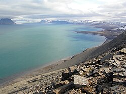
Svalbard, previously known as Spitsbergen or Spitzbergen, is a Norwegian archipelago in the Arctic Ocean. North of mainland Europe, it lies about midway between the northern coast of Norway and the North Pole. The islands of the group range from 74° to 81° north latitude, and from 10° to 35° east longitude. The largest island is Spitsbergen, followed in size by Nordaustlandet and Edgeøya. The largest settlement is Longyearbyen on the west coast of Spitsbergen.
Spitsbergen is the largest and the only permanently populated island of the Svalbard archipelago in northern Norway.
A dependent territory, dependent area, or dependency is a territory that does not possess full political independence or sovereignty as a sovereign state and remains politically outside the controlling state's integral area. As such, a dependent territory includes a range of non-integrated not fully to non-independent territory types, from associated states to non-self-governing territories.
Svalbard and Jan Mayen is a statistical designation defined by ISO 3166-1 for a collective grouping of two remote jurisdictions of Norway: Svalbard and Jan Mayen. While the two are combined for the purposes of the International Organization for Standardization (ISO) category, they are not administratively related. This has further resulted in the country code top-level domain .sj being issued for Svalbard and Jan Mayen, and ISO 3166-2:SJ. The United Nations Statistics Division also uses this code, but has named it the Svalbard and Jan Mayen Islands.
The Treaty of Kiel or Peace of Kiel was concluded between the United Kingdom of Great Britain and Ireland and the Kingdom of Sweden on one side and the Kingdoms of Denmark and Norway on the other side on 14 January 1814 in Kiel. It ended the hostilities between the parties in the ongoing Napoleonic Wars, where the United Kingdom and Sweden were part of the anti-French camp while Denmark–Norway was allied to France.
The Greenland Sea is a body of water that borders Greenland to the west, the Svalbard archipelago to the east, Fram Strait and the Arctic Ocean to the north, and the Norwegian Sea and Iceland to the south. The Greenland Sea is often defined as part of the Arctic Ocean, sometimes as part of the Atlantic Ocean. However, definitions of the Arctic Ocean and its seas tend to be imprecise or arbitrary. In general usage the term "Arctic Ocean" would exclude the Greenland Sea. In oceanographic studies the Greenland Sea is considered part of the Nordic Seas, along with the Norwegian Sea. The Nordic Seas are the main connection between the Arctic and Atlantic oceans and, as such, could be of great significance in a possible shutdown of thermohaline circulation. In oceanography the Arctic Ocean and Nordic Seas are often referred to collectively as the "Arctic Mediterranean Sea", a marginal sea of the Atlantic.
UTC+01:00 is an identifier for a time offset from UTC of +01:00. In ISO 8601, the associated time would be written as 2019-02-07T23:28:34+01:00. This time is used in:
Svalbard lies under the sovereignty of Norway, but the Svalbard Treaty places several restrictions. Norway cannot use the archipelago for warlike purposes, cannot discriminate economic activity based on nationality and is required to conserve the natural environment. Uniquely, Svalbard is an entirely visa-free zone. Everybody may live and work in Svalbard indefinitely regardless of country of citizenship. Svalbard Treaty grants treaty nationals equal right of abode as Norwegian nationals. Non-treaty nationals may live and work indefinitely visa-free as well. "Regulations concerning rejection and expulsion from Svalbard" is in force on non-discriminatory basis.
Erik the Red's Land was the name given by Norwegians to an area on the coast of eastern Greenland occupied by Norway in the early 1930s. It was named after Erik the Red, the founder of the first Norse or Viking settlements in Greenland in the 10th century. The Permanent Court of International Justice ruled against Norway in 1933, and the country subsequently abandoned its claims.
Denmark and Norway have a very long history together: they were both part of the Kalmar Union between 1397 and 1523, and Norway was in a Union with Denmark between 1524 and 1814.
Norway's elongated shape, its numerous internal geographical barriers and the often widely dispersed and separated settlements are all factors that have strongly influenced the structure of the country's administrative subdivisions. This structure has varied over time and is subject to continuous review. In 2017, the government decided to abolish some of the counties and to merge them with other counties to form larger ones, reducing the number of counties from 19 to 11, which was implemented on 1 January 2020. Following protests, the new government decided to abolish three of the new counties in 2022, and re-establish seven of the old ones. Taking effect on 1 January 2024 there are fifteen counties in Norway.
Norway has three dependent territories, all uninhabited and located in the Southern Hemisphere. Bouvet Island (Bouvetøya) is a sub-Antarctic island in the South Atlantic Ocean. Queen Maud Land is the sector of Antarctica between the 20th meridian west and the 45th meridian east. Peter I Island is a volcanic island located 450 kilometres (280 mi) off the coast of Ellsworth Land of continental Antarctica. Despite being unincorporated areas, neither Svalbard nor Jan Mayen is formally considered a dependency. While the Svalbard Treaty regulates some aspects of that Arctic territory, it acknowledges that the islands are part of Norway. Similarly, Jan Mayen is recognized as an integral part of Norway.
ISO 3166-2:SJ is the entry for Svalbard and Jan Mayen in ISO 3166-2, part of the ISO 3166 standard published by the International Organization for Standardization (ISO). The standard defines codes for names of principal subdivisions of all countries coded in ISO 3166-1. Svalbard and Jan Mayen does not exist as an administrative region, but rather consists of two separate parts of Norway under separate jurisdictions—Svalbard and Jan Mayen. Further subdivision for Svalbard and Jan Mayen occurs under Norway's entry, ISO 3166-2:NO, namely NO-21 for Svalbard and NO-22 for Jan Mayen. There are currently no ISO 3166-2 codes for Svalbard and Jan Mayen.
The term Norwegian Realm and Old Kingdom of Norway refer to the Kingdom of Norway's peak of power at the 13th century after a long period of civil war before 1240. The kingdom was a loosely unified nation including the territory of modern-day Norway, modern-day Swedish territory of Jämtland, Herjedalen, Ranrike (Bohuslän) and Idre and Särna, as well as Norway's overseas possessions which had been settled by Norwegian seafarers for centuries before being annexed or incorporated into the kingdom as 'tax territories'. To the North, Norway also bordered extensive tax territories on the mainland. Norway, whose expansionism starts from the very foundation of the Kingdom in 872, reached the peak of its power in the years between 1240 and 1319.
Hallvard Ophuus Devold was a Norwegian Arctic explorer, trapper and meteorologist. He was instrumental in the attempt to establish Eric the Red's Land in 1931. His brother Finn Devold (1902–1977) shared his vision and helped to establish a Norwegian station at Finnsbu, SE Greenland.
Finn Devold was a Norwegian Arctic explorer, marine biologist and meteorologist. His father was parish priest Harald Ophus Devold. Together with his brother Hallvard Devold, Finn shared an interest in the Arctic areas and in the expansion of Norwegian sovereignty across Greenland.