Polar regions of Earth

Last updated

Visualization of the ice and snow covering Earth's northern and southern polar regions
Northern Hemisphere permafrost (permanently frozen ground) in purple Frozenground.gif
Northern Hemisphere permafrost (permanently frozen ground) in purple

The polar regions, also called the frigid zones or polar zones, of Earth are Earth's polar ice caps, the regions of the planet that surround its geographical poles (the North and South Poles), lying within the polar circles. These high latitudes are dominated by floating sea ice covering much of the Arctic Ocean in the north, and by the Antarctic ice sheet on the continent of Antarctica and the Southern Ocean in the south.

Contents

Definitions

The Arctic has various definitions, including the region north of the Arctic Circle (currently Epoch 2010 at 66°33'44" N), or just the region north of 60° north latitude, or the region from the North Pole south to the timberline. The Antarctic is usually defined simply as south of 60° south latitude, or the continent of Antarctica. The 1959 Antarctic Treaty uses the former definition.

The two polar regions are distinguished from the other two climatic and biometric belts of Earth, a tropics belt near the equator, and two middle latitude regions located between the tropics and polar regions.

Climate

Polar regions receive less intense solar radiation than the other parts of Earth because the Sun's energy arrives at an oblique angle, spreading over a larger area, being less concentrated, and also travels a longer distance through the Earth's atmosphere in which it may be absorbed, scattered or reflected, which is the same thing that causes winters to be colder than the rest of the year except in tropical regions.

The axial tilt of the Earth has the most effect on climate of the polar regions due to its latitude. However, since the polar regions are the farthest from the equator, they receive the weakest solar radiation and are therefore generally frigid year round due to the earth's axial tilt of 23.5° not being enough to create a high maximum midday declination to sufficiently compensate the Sun's rays for the high latitude even in summer, except for relatively brief periods in peripheral areas near the polar circles. The large amount of ice and snow also reflects and weakens of what weak sunlight the polar regions receive further, contributing to the cold. Polar regions are characterized by extremely cold temperatures, heavy glaciation wherever there is sufficient precipitation to form permanent ice, short and still cold summers, and extreme variations in daylight hours, with twenty-four hours of daylight in summer, and complete darkness at mid-winter.

Circumpolar Arctic region

North polar region polar bears Polar Bear 2004-11-15.jpg
North polar region polar bears

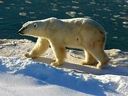
There are many settlements in Earth's north polar region. Countries with claims to Arctic regions are: the United States (Alaska), Canada (Yukon, the Northwest Territories and Nunavut), Denmark (Greenland), Norway, Finland, Sweden, Iceland, and Russia. Arctic circumpolar populations, though small, often share more in common with each other than with other populations within their national boundaries. As such, the northern polar region is diverse in human settlements and cultures.

Antarctica and the Southern sea

South polar region penguin Pygoscelis papua.jpg
South polar region penguin

The southern polar region has no permanent human habitation as of now. [1] McMurdo Station is the largest research station in Antarctica, run by the United States. Other notable stations include Palmer Station and Amundsen–Scott South Pole Station (United States), Esperanza Base and Marambio Base (Argentina), Scott Base (New Zealand), and Vostok Station (Russia).

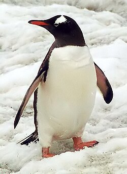
While there are no indigenous human cultures, there is a complex ecosystem, especially along Antarctica's coastal zones. Coastal upwelling provides abundant nutrients which feeds krill, a type of marine Crustacea, which in turn feeds a complex of living creatures from penguins to blue whales.

See also

Related Research Articles

<span class="mw-page-title-main">Polar climate</span> Climate classification

The polar climate regions are characterized by a lack of warm summers but with varying winters. Every month a polar climate has an average temperature of less than 0 °C (32 °F). Regions with a polar climate cover more than 20% of the Earth's area. Most of these regions are far from the equator and near the poles, and in this case, winter days are extremely short and summer days are extremely long. A polar climate consists of cool summers and very cold winters, which results in treeless tundra, glaciers, or a permanent or semi-permanent layer of ice. It is identified with the letter E in the Köppen climate classification.

<span class="mw-page-title-main">Tropics</span> Region of Earth surrounding the Equator

The tropics are the regions of Earth surrounding the Equator. They are defined in latitude by the Tropic of Cancer in the Northern Hemisphere at 23°26′10.3″ (or 23.43619°) N and the Tropic of Capricorn in the Southern Hemisphere at 23°26′10.3″ (or 23.43619°) S. The tropics are also referred to as the tropical zone and the torrid zone.

<span class="mw-page-title-main">Tropic of Cancer</span> Line of northernmost latitude at which the Sun can be directly overhead

The Tropic of Cancer, which is also referred to as the Northern Tropic, is the most northerly circle of latitude on Earth at which the Sun can be directly overhead. This occurs on the June solstice, when the Northern Hemisphere is tilted toward the Sun to its maximum extent. It also reaches 90 degrees below the horizon at solar midnight on the December Solstice. Using a continuously updated formula, the circle is currently 23°26′10.3″ (or 23.43619°) north of the Equator.

<span class="mw-page-title-main">Tropic of Capricorn</span> Line of southernmost latitude at which the sun can be directly overhead

The Tropic of Capricorn is the circle of latitude that contains the subsolar point at the December solstice. It is thus the southernmost latitude where the Sun can be seen directly overhead. It also reaches 90 degrees below the horizon at solar midnight on the June Solstice. Its northern equivalent is the Tropic of Cancer.

<span class="mw-page-title-main">Circle of latitude</span> Geographic notion

A circle of latitude or line of latitude on Earth is an abstract east–west small circle connecting all locations around Earth at a given latitude coordinate line.

<span class="mw-page-title-main">Polar circle</span> Circle of latitude

A polar circle is a geographic term for a conditional circular line (arc) referring either to the Arctic Circle or the Antarctic Circle. These are two of the keynote circles of latitude (parallels). On Earth, the Arctic Circle is currently drifting northwards at a speed of about 14.5 m per year and is now at a mean latitude of 66°33′49.7″ N; the Antarctic Circle is currently drifting southwards at a speed of about 14.5 m per year and is now at a mean latitude of 66°33′49.7″ S. Polar circles are often equated with polar regions of Earth. Due to their inherent climate environment, the bulk of the Arctic Circle, much of which is sea, is sparsely settled whereas this applies to all of Antarctica which is mainly land and sheltered ice shelves.

<span class="mw-page-title-main">Midnight sun</span> Natural phenomenon when daylight lasts for a whole day

Midnight sun is a natural phenomenon that occurs in the summer months in places north of the Arctic Circle or south of the Antarctic Circle, when the Sun remains visible at the local midnight. When midnight sun is seen in the Arctic, the Sun appears to move from left to right. In Antarctica, the equivalent apparent motion is from right to left. This occurs at latitudes from 65°44' to 90° north or south, and does not stop exactly at the Arctic Circle or the Antarctic Circle, due to refraction.

<span class="mw-page-title-main">Atmospheric circulation</span> Process which distributes thermal energy about the Earths surface

Atmospheric circulation is the large-scale movement of air and together with ocean circulation is the means by which thermal energy is redistributed on the surface of the Earth. The Earth's atmospheric circulation varies from year to year, but the large-scale structure of its circulation remains fairly constant. The smaller-scale weather systems – mid-latitude depressions, or tropical convective cells – occur chaotically, and long-range weather predictions of those cannot be made beyond ten days in practice, or a month in theory.

<span class="mw-page-title-main">Polar night</span> Night lasting for more than 24 hours

Polar night is a phenomenon in the northernmost and southernmost regions of Earth where night lasts for more than 24 hours. This occurs only inside the polar circles. The opposite phenomenon, polar day, or midnight sun, occurs when the Sun remains above the horizon for more than 24 hours.

Polar ecology is the relationship between plants and animals in a polar environment. Polar environments are in the Arctic and Antarctic regions. Arctic regions are in the Northern Hemisphere, and it contains land and the islands that surrounds it. Antarctica is in the Southern Hemisphere and it also contains the land mass, surrounding islands and the ocean. Polar regions also contain the subantarctic and subarctic zone which separate the polar regions from the temperate regions. Antarctica and the Arctic lie in the polar circles. The polar circles are imaginary lines shown on maps to be the areas that receives less sunlight due to less radiation. These areas either receive sunlight or shade 24 hours a day because of the earth's tilt. Plants and animals in the polar regions are able to withstand living in harsh weather conditions but are facing environmental threats that limit their survival.

<span class="mw-page-title-main">Geographical zone</span> Major regions of Earths surface demarcated by latitude

The five main latitude regions of Earth's surface comprise geographical zones, divided by the major circles of latitude. The differences between them relate to climate. They are as follows:

  1. The North Frigid Zone, between the North Pole at 90° N and the Arctic Circle at 66°33′48.7" N, covers 4.12% of Earth's surface.
  2. The North Temperate Zone, between the Arctic Circle at 66°33′48.7" N and the Tropic of Cancer at 23°26'11.3" N, covers 25.99% of Earth's surface.
  3. The Torrid Zone, between the Tropic of Cancer at 23°26'11.3" N and the Tropic of Capricorn at 23°26'11.3" S, covers 39.78% of Earth's surface.
  4. The South Temperate Zone, between the Tropic of Capricorn at 23°26'11.3" S and the Antarctic Circle at 66°33'48.7" S, covers 25.99% of Earth's surface.
  5. The South Frigid Zone, from the Antarctic Circle at 66°33'48.7" S and the South Pole at 90° S, covers 4.12% of Earth's surface.
<span class="mw-page-title-main">Daytime</span> Period of a day in which a location experiences natural illumination

Daytime as observed on Earth is the period of the day during which a given location experiences natural illumination from direct sunlight. Daytime occurs when the Sun appears above the local horizon, that is, anywhere on the globe's hemisphere facing the Sun. In direct sunlight the movement of the sun can be recorded and observed using a sundial that casts a shadow that slowly moves during the day. Other planets and natural satellites that rotate relative to a luminous primary body, such as a local star, also experience daytime, but this article primarily discusses daytime on Earth.

<span class="mw-page-title-main">Climate of the Arctic</span>

The climate of the Arctic is characterized by long, cold winters and short, cool summers. There is a large amount of variability in climate across the Arctic, but all regions experience extremes of solar radiation in both summer and winter. Some parts of the Arctic are covered by ice year-round, and nearly all parts of the Arctic experience long periods with some form of ice on the surface.

<span class="mw-page-title-main">South Pole</span> Southernmost point on Earth

The South Pole, also known as the Geographic South Pole, Terrestrial South Pole or 90th Parallel South, is the southernmost point on Earth and lies antipodally on the opposite side of Earth from the North Pole, at a distance of 12,430 miles in all directions. It is one of the two points where Earth's axis of rotation intersects its surface.

<span class="mw-page-title-main">Equator</span> Imaginary line halfway between Earths North and South poles

The equator is a circle of latitude that divides a spheroid, such as Earth, into the northern and southern hemispheres. On Earth, it is an imaginary line located at 0 degrees latitude, about 40,075 km (24,901 mi) in circumference, halfway between the North and South poles. The term can also be used for any other celestial body that is roughly spherical.

<span class="mw-page-title-main">Season</span> Subdivision of the year based on orbit and axial tilt

A season is a division of the year based on changes in weather, ecology, and the number of daylight hours in a given region. On Earth, seasons are the result of the axial parallelism of Earth's tilted orbit around the Sun. In temperate and polar regions, the seasons are marked by changes in the intensity of sunlight that reaches the Earth's surface, variations of which may cause animals to undergo hibernation or to migrate, and plants to be dormant. Various cultures define the number and nature of seasons based on regional variations, and as such there are a number of both modern and historical cultures whose number of seasons varies.

<span class="mw-page-title-main">Ice cap climate</span> Polar climate where no mean monthly temperature exceeds 0 °C (32 °F)

An ice cap climate is a polar climate where no mean monthly temperature exceeds 0 °C (32 °F). The climate generally covers areas at high altitudes and polar regions, such as Antarctica and some of the northernmost islands of Canada and Russia. Most of Greenland is under the influence of an ice cap climate, although the coasts are prone to more influence from the sea, providing more ET climates. Some regions on the islands of Norway's Svalbard Archipelago facilitate an EF climate. Areas with ice cap climates are normally covered by a permanent layer of ice and have no vegetation. There is limited animal life in most ice cap climates, which are usually found near the oceanic margins. Although ice cap climates are inhospitable to human life, there are some research stations scattered in Antarctica and interior Greenland.

<span class="mw-page-title-main">Antarctic Circle</span> Boundary of the Antarctic

The Antarctic Circle is the most southerly of the five major circles of latitude that mark maps of Earth. The region south of this circle is known as the Antarctic, and the zone immediately to the north is called the Southern Temperate Zone. South of the Antarctic Circle, the Sun is above the horizon for 24 continuous hours at least once per year and the centre of the Sun is below the horizon for 24 continuous hours at least once per year ; this is also true within the equivalent polar circle in the Northern Hemisphere, the Arctic Circle.

<span class="mw-page-title-main">Arctic Circle</span> Boundary of the Arctic

The Arctic Circle is one of the two polar circles, and the most northerly of the five major circles of latitude as shown on maps of Earth at about 66° 34' N. Its southern equivalent is the Antarctic Circle.

<span class="mw-page-title-main">Climate of Pluto</span> Types of climate on the dwarf planet Pluto

The dwarf planet Pluto has an unusual set of climate zones, due to its atypical axial configuration. Five climate zones are assigned on the dwarf planet: tropics, arctic, tropical arctic, diurnal, and polar. These climate zones are delineated based on astronomically defined boundaries or sub-solar latitudes, which are not associated with the atmospheric circulations on the dwarf planet. Charon, the largest moon of Pluto, is tidally locked with it, and thus has the same climate zone structure as Pluto itself.

References

  1. Matthew Teller (20 June 2014). "Why do so many nations want a piece of Antarctica?". BBC. Retrieved 22 March 2019.

Further reading