 | |
| Area | 13,100,000 km2 (5,100,000 sq mi) |
|---|---|
| Population | 37 million (2021 census) |
| Population density | 2.6 per km2 (7.4 per mi2) |
| GDP (PPP) | $1.3 trillion (2022) |
| GDP (nominal) | $600 billion (2022) [1] |
| GDP per capita | $16,000 (2022) |
| Ethnic groups | Majority Slavic Minority Tungusic, Mongolic, Turkic, and other indigenous peoples of Siberia |
| Religions | Majority Orthodox Christian |
| Demonym | Siberian, North Asian |
| Countries | |
| Languages | Official languages Other languages |
| Time zones | |
| Internet TLD | .ru |
| Calling code | Zone 7 |
| Largest cities | |
| UN M49 code | 151 – Eastern Europe 150 – Europe 001 – World |
| North Asia | |
|---|---|
| Russian name | |
| Russian | Северная Азия |
| Romanization | Severnaya Aziya |
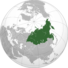
North Asia or Northern Asia is the northern region of Asia,which is defined in geographical terms and consists of three federal districts of Russia:Ural,Siberian,and the Far Eastern. The region forms the bulk of the Asian part of Russia. North Asia is bordered by the Arctic Ocean to its north;by Eastern Europe to its west;by Central Asia and East Asia to its south;and by the Pacific Ocean and Northern America to its east. It covers an area of 13,100,000 square kilometres (5,100,000 sq mi),or 8.8% of Earth's total land area;and is the largest subregion of Asia by area,occupying approx. 29.4% of Asia's land area,but is also the least populated,with a population of around 37 million,accounting for merely 0.74% of Asia's population.
Contents
Topographically,the region is dominated by the Eurasian Plate,except for its eastern part,which lies on the North American,Amurian,and Okhotsk Plates. It is divided by three major plains:the West Siberian Plain,Central Siberian Plateau,and Verhoyansk-Chukotka collision zone. The Uralian orogeny in the west raised Ural Mountains,the informal boundary between Asia and Europe. Tectonic and volcanic activities are frequently occurred in the eastern part of the region as part of the Ring of Fire,evidenced by the formation of island arcs such as the Kuril Islands and ultra-prominent peaks such as Klyuchevskaya Sopka,Kronotsky,and Koryaksky. The central part of North Asia is a large igneous province called the Siberian Traps,formed by a massive eruption which occurred 250 million years ago. The formation of the traps coincided with the Permian–Triassic extinction event.
Geographically,North Asia is a subregion of Asia. Historically,it has been home to various East Asian-related ethnic groups from a diverse range of language families,including the Ainu,Chukotko-Kamchatkan,Mongolic,Nivkh,Tungusic,Turkic,Uralic,Yeniseian,Yukaghir,and Eskaleut peoples. However,due to the Russian conquest of Siberia,the entirety of North Asia was colonised and incorporated into Russia. Consequently,some international organisations classify North Asia as part of Eastern Europe along with European Russia,rather than as a part of Asia. European cultural influences,specifically Russian,are predominant in the entire region,due to it experiencing Russian emigration from Europe starting from the 16th century. [2] Slavs and other Indo-Europeans make up the vast majority of North Asia's population,and over 85% of the region's population is of European descent. [3] [4] Whereas the indigenous peoples comprise only about 5% of the North Asian population. [5]