Eastern Coastal Plains | |
|---|---|
Geographical region | |
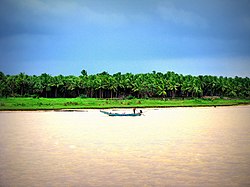    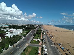  Clockwise from top left: Godavari in Andhra plains; Mahanadi in Utkal Plains; Kaveri delta; Chilika Lake; Coromandel Coast in Chennai; Krishna River | |
 Physical map of India, showing the different topographical regions | |
| Coordinates: 15°N80°E / 15°N 80°E | |
| Country | India |
| State(s) | |
| Largest city | Chennai |
| Languages | |
| • Major | Odia, Tamil, Telugu |
| Time zone | Indian Standard Time |
The Eastern Coastal Plains is a stretch of landmass lying between the eastern part of the Deccan Plateau and the Bay of Bengal in India. The plains stretch from the Mahanadi delta to Kaniyakumari at the southern tip of the Indian peninsula with the Eastern Ghats forming its rough western boundary. It is wider and leveled than the Western Coastal Plains and traverses the states of Odisha, Andhra Pradesh, and Tamil Nadu.
Contents
The plains are broadly divided into three subdivisions– Utkal Plains in the north, Andhra plains in the center, and Tamil Nadu plains in the south. The plains are fertile as it forms part of the deltas of major peninsular rivers such as Godavari, Krishna, Mahanadi, and Kaveri.