Frontispiece to Alfred Russel Wallace's book The Geographical Distribution of Animals
Biogeographic classification of India is the division of India according to biogeographic characteristics. Biogeography is the study of the distribution of species (biology), organisms, and ecosystems in geographic space and through geological time. India has a rich heritage of natural diversity. India ranks fourth in Asia and tenth in the world amongst the top 17 mega-diverse countries in the world.[1] India harbours nearly 11% of the world's floral diversity comprising over 17500 documented flowering plants, 6200 endemic species, 7500 medicinal plants and 246 globally threatened species in only 2.4% of world's land area.[2] India is also home to four biodiversity hotspots—Andaman & Nicobar Islands, Eastern Himalaya, Indo-Burma region, and the Western Ghats.[3] Hence the importance of biogeographical study of India's natural heritage.
The first initiative to classify the forests of India was done by Champion in 1936 and revised by Seth in 1968.[4] This was followed by pioneering work on India's biogeography by MS Mani in 1974.[5] Numerous schemes divide India into biogeographic regions as part of global schemes based on varying parameters, e.g. the Global 200 scheme of the Worldwide Fund for Nature. In addition, ongoing research focusing on particular taxa have included biogeographic aspects particular to the taxa under study and the area under consideration.
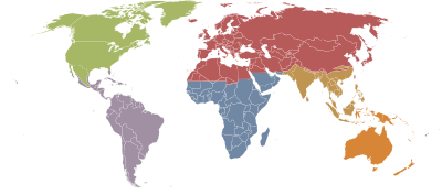
At the broadest level, referred to as realm in Udvardy (1975),[8][9] all of India falls in the Indomalayan realm, with the exception of the high Himalayas, which fall in the Palearctic realm.
Most of India falls in the "Indian Subcontinent" bioregion of the Indomalayan realm, which covers most of India, Pakistan, Bangladesh, Nepal, Bhutan, and Sri Lanka. The Hindu Kush, Karakoram, Himalaya, and Patkai ranges bound the bioregion on the northwest, north, and northeast; these ranges were formed by the collision of the northward-drifting Indian subcontinent with Asia beginning 45 million years ago. The Hindu Kush, Karakoram, and Himalaya are a major biogeographic boundary between the subtropical and tropical flora and fauna of the Indian subcontinent and the temperate-climate Palearctic realm.
The Nicobar islands on the other hand fall in the "Sundaland" bioregion of the Indo-Malayan realm.
The Himalayas proper form the southern limit of the Palearctic in South Asia, and here the Palearctic temperate forests transition to the subtropical and tropical forests of Indomalaya, creating a rich and diverse mix of plant and animal species.
Based on Olson et al. (2001),[9] the Worldwide Fund for Nature divided the land area of world into 14 terrestrial biomes or habitat types, based on vegetation,[Note 1] which are further subdivided into a total of 867 terrestrial ecoregions,[Note 2] which are exemplars of the concerned biome or habitat type.[10][11] The classification also includes seven fresh-water biomes and 5 marine biomes.[10] Each biome contains many ecoregions that are examples of that type of habitat.[10] The purpose of this classification scheme is to identify ecoregions that are conservation priorities. These priority regions are referred to collectively as the WWF's Global 200.[9]
Only two terrestrial ecoregions from India – the Western Ghats and the Eastern Himalayas – figure in the Global 200 priority list of the WWF.[11]
Terrestrial biomes of India
The following 11 terrestrial biomes are found in India:[9]
The first proper classification of forest types of India was done by Champion in 1936 and revised by S.K. Seth in 1968.[4] It was further revised by Mathur in 2000.[citation needed] Champion and Seth (1968) classified the Indian forest using temperature and rainfall data into five major forest groups and 16 type groups (climatic types) and over 200 subgroup types. Although this classification was widely accepted, as time passed it was found to have certain drawbacks. The purpose of the classification by Champion was primarily forest use, specifically timber extraction. As time passed, the nature of Indian forestry changed to forest conservation, with new emphasis on the increasing role of forests in environment amelioration and climate change mitigation/adaptation. The classification into over 200 subgroups created problems of needless complexity for forest managers.[citation needed]
The Forest Survey of India (FSI), under the aegis of ICFRE, published the Atlas Forest Type of India in 2011.[6] The forest type atlas contained forest type maps for India which were digitised for the first time. The forest type maps were prepared on 1;50,000 scale according to the Champion & Seth classification (1968) of the country and included States and UTs and districts. The output of this mapping exercise covers 178 out of 200 forest types described in the Champion & Seth classification (1968). Ground-proofing, further survey and reclassification actions are intended by the ICFRE to simplify this classification even further.[citation needed]
Biogeographic zones
Rogers and Panwar of the Wildlife Institute of India (WII) outlined a scheme to divide India zoogeographically in 1986 while planning a protected area network for India.[12] The scheme divided India into 10 biogeographic zones, and each zone is further subdivided into biogeographic provinces, which total 27 in number. 1. Trans Himalayan zone. 2. Himalayan zone 3. Desert zone. 4. Semiarid zone. 5. Western ghat zone. 6. Deccan plateau zone. 7. Gangetic plain zone. 8. North east zone. 9. Coastal zone. 10. Islands
Zone 1 – Trans-Himalayan Region
The Himalayan ranges immediately north of the Great Himalayan range are called the Trans-Himalayas. It comprises three biogeographic provinces – Ladakh mountains, Tibetan plateau and Himalayan Sikkim. It accounts for ~5.6% of the country's landmass.[2] This region mostly lies between 4,500 to 6,000 metres (14,800 to 19,700ft) and is very cold and arid. The only vegetation is a sparse alpine steppe. Extensive areas consist of bare rock and glaciers.[2][13]
The Trans-Himalayan region with its sparse vegetation has the richest wild sheep and goat community in the world. The snow leopard, black and brown bears, wolf, marmots, marbled cat, ibex, and kiang is found here, as are the migratory Black-necked Cranes.[14][15]
Zone 2 – Himalayas
Bio-geographical representation of himalayas.
The Himalayas consist of the youngest and loftiest mountain chains in the world. The 2,400 kilometres (1,500mi) long Himalayan mountain arc have a unique biodiversity owing to their high altitude, steep gradient and rich temperate flora;[16] biogeographically, they form part of the Palearctic realm. The Himalayas have three biogeographical provinces – Northwest Himalayas, West Himalayas, Central Himalayas and East Himalayas, which together constitute about 6.4% of the country's area.[2][13]
Tropical rainforests predominate in the Eastern Himalayas while dense subtropical and alpine forests are typical in the Central and Western Himalayas. Oak, chestnut, conifer, ash, pine, and deodar are abundant in Himalayas. Important animals living in the Himalayan ranges include wild sheep, mountain goats, ibex, musk deer and serow. Red panda, black bear, dholes, wolves, martens, weasels, leopard and snow leopard are also found here. However carnivores are scarce and often locally threatened.[13]
Zone 3 – The Indian Desert
This region consists of two biogeographical provinces. The larger is the Thar or Great Indian Desert, adjoining Pakistan and which comprises Rajasthan and parts of Punjab and Haryana. The Indian part of the Thar desert occupies 170,000km2 (66,000sqmi).[17] The climate is characterised by very hot and dry summer and cold winter. Rainfall is less than 70cm. The plants are mostly xerophytic. Babul, Kikar, and wild date palm grow in areas of moderate rainfall. The Indian Bustard, a highly endangered bird is found here. Camels, gazelles, foxes, spiny-tailed lizards and snakes are found in hot and arid parts of the desert.[18][15]
Adjoining the desert are the semi-arid areas, a transitional zone between the desert and the denser forests of the Western Ghats. The natural vegetation is thorn forest. This region is characterised by discontinuous vegetation cover with open areas of bare soil and soil-water deficit throughout the year.
The mountains along the west coast of peninsular India are the Western Ghats, which constitute one of the unique biological regions of the world. The Western Ghats extend from the southern tip of the peninsula (8°N) northwards about 1600km to the mouth of the river Tapi (21°N).
The mountains rise to average altitudes between 900 and 1500 m above sea level, intercepting monsoon winds from the southwest and creating a rain shadow in the region to their East.
The varied climate and diverse topography create a wide array of habitats that support unique sets of plant and animal species. Apart from biological diversity, the region boasts of high levels of cultural diversity, as many indigenous people inhabit its forests.
The Western Ghats are amongst the 25 biodiversity hot-spots recognized globally. These hills are known for their high levels of endemism expressed at both higher and lower taxonomic levels. Most of the Western Ghat endemic plants are associated with evergreen forests.
The region also shares several plant species with Sri Lanka. The higher altitude forests were, if at all, sparsely populated with tribal people. Rice cultivation in the fertile valley proceeded gardens of early commercial crops like areca nut and pepper. The original vegetation of the ill-drained valley bottoms with sluggish streams in elevations below 100m would be often a special formation, the Myristica swamp.
Expansion of traditional agriculture and the spread of particularly rubber, tea, coffee and forest tree plantations would have wiped out large pockets of primary forests in valleys. The Western Ghats are well known for harboring 14 endemic species of caecilians (i.e., legless amphibians) out of 15 recorded from the region so far.
Zone 6 - Deccan Plateau
Beyond the Ghats is Deccan Plateau, a semi-arid region lying in the rain shadow of the Western ghats . This is the largest unit of the Peninsular Plateau of India. The highlands of the plateau are covered with different types of forests, which provide a large variety of forest products. The Deccan plateau includes the region lying south of the Satpura range.it extends up to the southern tip of peninsular India. Anai mudi is the highest peak of this region. The Deccan plateau is surrounded by the western and the eastern ghats. These ghats meet each other at the Nilgiri hills. The western ghats includes the Sahyadri, Nilgiris, Anamalai, and cardamom hills.many rivers such as Mahanadi, Godavari, krishna, and kaveri originates from western ghats and flow toward the east. The eastern ghats are broken into small hill ranges by river coming from the western ghats. Most of these rivers empty into the Bay of Bengal. The Godavari is the longest river in the Deccan plateau. The Narmada and the Tapi flow westwards and fall into the Arabian sea.
Zone 7 - Gangetic Plain
In the North is the Gangetic plain extending up to the Himalayan foothills. This is the largest unit of the Great Plain of India. Ganga is the main river after whose name this plain is named. The aggradational Great Plains cover about 72.4mha area with the Ganga and the Brahmaputra forming the main drainage axes in the major portion.
The thickness in the alluvial sediments varies considerably with its maximum in the Ganga plains. The physiogeographic scenery varies greatly from arid and semi-arid landscapes of the Rajasthan Plains to the humid and per-humid landscapes of the Delta and Assam valley in the east.
Topographic uniformity, except in the arid Western Rajasthan is a common feature throughout these plains. The plain supports some of the highest population densities depending upon purely agro-based economy in some of these areas. The trees belonging to these forests are teak, sal, shisham, mahua, khair etc.
Zone 8 - North-East India
North-east India is one of the poorest regions in the country. It has several species of orchids, bamboos, ferns and other plants. Here the wild relatives of cultivated plants such as banana, mango, citrus and pepper can be grown.
Zone 9 - Islands
The two groups of islands, i.e., the Arabian Sea islands and Bay Islands differ significantly in origin and physical characteristics. The Arabian Sea Islands (Laccadive, Minicoy, etc.) are the foundered remnants of the old land mass and subsequent coral formations. On the other hand, the Bay Islands lay only about 220km.
Away from the nearest point on the main land mass and extend about 590km. With a maximum width of 58km the island forests of Lakshadweep in the Arabian Sea have some of the best-preserved evergreen forests of India. Some of the islands are fringed with coral reefs. Many of them are covered with thick forests and some are highly dissected.
Zone 10 - Coasts
India has a coastline extending over 7,516. 4km. The Indian coasts vary in their characteristics and structures. The west coast is narrow except around the Gulf of Cambay and the Gulf of Kutch. In the extreme south, however, it is somewhat wider along the south Sahyadri.
The backwaters are the characteristic features of this coast. The east coast plains, in contrast are broader due to depositional activities of the east-flowing rivers owing to the change in their base levels.
Extensive deltas of the, Godavari, Krishna and Kaveri are the characteristic features of this coast. Mangrove vegetation is characteristic of estuarine tracts along the coast for instance, at Ratnagiri in Maharashtra.
Larger parts of the coastal plains are covered by fertile soils on which different crops are grown. Rice is the main crop of these areas. Coconut trees grow all along the coast.
Coconut and rubber are the main vegetation of coastal area. The main states of coastal areas are- Gujarat, Maharashtra, Goa, Karnataka, Kerala, west Bengal, Odisha, Andhra Pradesh, Tamil Nadu and Puducherry.
Biodiversity hotspots
Biodiversity hotspots of India—Eastern Himalayas: 32; Indo-Burma: 19; Western Ghats and Sri Lanka: 21; and Sundaland (which includes Nicobar Islands): 16.
India also figures prominently in the list of the biodiversity hotspots of the world. A "biodiversity hotspot" is a biogeographical region with significant levels of biodiversity that is threatened by human habitation.[22] This concept was developed by the British environmental expert Norman Myers in 1998 and subsequent years, and finalised in a paper published in Nature in 2000.[23] A total of 25 hotspots were identified at first in which are found as many as 44% of all species of vascular plants and 35% of all species in four vertebrate in just 1.4% of the land surface of the Earth.[23] An additional 10 hotspots were added subsequently.[24][25] The concept of biodiversity hotspots designates those areas most important from the point of view of biodiversity, and is of special importance to endemic species. The designated 35 hotspots harbour over 50% of the world's endemic plant species and 42% of all endemic terrestrial vertebrate species, yet they constitute only 2.3% of the Earth's land surface. Biodiversity hotspots are even more crucial for conservation as each hotspot faces substantial and numerous threats; each hotspot is estimated to have already lost at least 70% of its original natural vegetation.[3]
India is home to four biodiversity hotspots—Andaman & Nicobar Islands, Eastern Himalaya, Indo-Burma region, and the Western Ghats.[3]
Andaman & Nicobar Islands
The Andaman islands (as part of serial 19 Indo-Burma) and Nicobar Islands (as part of serial 16 Sundaland).
Eastern Himalaya
Serial 32 in the list. The Eastern Himalayas was originally part of the Indo-Burma Biodiversity Hotspot. In 2004, a hotspot reappraisal classified the region as part of two hotspots: Indo-Burma and the newly distinguished Himalaya. The Eastern Himalaya includes Bhutan, southern, central and eastern Nepal, and northeastern India, and comprises 11 Key Biodiversity Areas (occupying 750,000 hectares). The region includes the lowland regions as well as montane regions and spans two realms —the Palearctic and the Indomalayan. The region has extremely rich plat and faunal communities as well as a number of iconic endangered species. A number of key protected areas are located in this biodiversity hotspot.[26]
Indo-Burma region
Serial 19 in the list.
Western Ghats
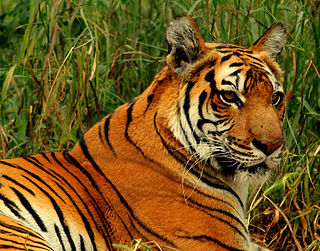
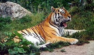
Serial 21 in the list. This region centres upon the Western Ghats range of mountains that runs along the west coast, which accounts for less than 6% of the national land area, but contains a rich endemic assemblage of plants, reptiles and amphibians, that comprises more than 30% of all bird, fish, herpetofauna, mammal, and plant species found in the country, including endangered iconic species such as the Asian elephant (Elephas maximus) and tiger (Panthera tigris), besides others.[27]
Important Bird areas
This section is empty. You can help by adding to it. (October 2021)
Notes
↑ The WWF defines "bioregions" are defined as: "geographic clusters of ecoregions that may span several habitat types, but have strong biogeographic affinities, particularly at taxonomic levels higher than the species level (genus, family)".
↑ The WWF defines an "ecoregion" as: a "large unit of land or water containing a geographically distinct assemblage of species, natural communities, and environmental conditions".
Related Research Articles
A biome is a distinct geographical region with specific climate, vegetation, and animal life. It consists of a biological community that has formed in response to its physical environment and regional climate. Biomes may span more than one continent. A biome encompasses multiple ecosystems within its boundaries. It can also comprise a variety of habitats.
India is situated north of the equator between 8°4' north to 37°6' north latitude and 68°7' east to 97°25' east longitude. It is the seventh-largest country in the world, with a total area of 3,287,263 square kilometres (1,269,219 sq mi). India measures 3,214 km (1,997 mi) from north to south and 2,933 km (1,822 mi) from east to west. It has a land frontier of 15,200 km (9,445 mi) and a coastline of 7,516.6 km (4,671 mi).
An ecoregion is an ecologically and geographically defined area that is smaller than a bioregion, which in turn is smaller than a biogeographic realm. Ecoregions cover relatively large areas of land or water, and contain characteristic, geographically distinct assemblages of natural communities and species. The biodiversity of flora, fauna and ecosystems that characterise an ecoregion tends to be distinct from that of other ecoregions. In theory, biodiversity or conservation ecoregions are relatively large areas of land or water where the probability of encountering different species and communities at any given point remains relatively constant, within an acceptable range of variation . Ecoregions are also known as "ecozones", although that term may also refer to biogeographic realms.
The Palearctic or Palaearctic is the largest of the eight biogeographic realms of the Earth. It stretches across all of Eurasia north of the foothills of the Himalayas, and North Africa.
The Global 200 is the list of ecoregions identified by the World Wide Fund for Nature (WWF), the global conservation organization, as priorities for conservation. According to WWF, an ecoregion is defined as a "relatively large unit of land or water containing a characteristic set of natural communities that share a large majority of their species dynamics, and environmental conditions". For example, based on their levels of endemism, Madagascar gets multiple listings, ancient Lake Baikal gets one, and the North American Great Lakes get none.
A biodiversity hotspot is a biogeographic region with significant levels of biodiversity that is threatened by human habitation. Norman Myers wrote about the concept in two articles in The Environmentalist in 1988 and 1990, after which the concept was revised following thorough analysis by Myers and others into "Hotspots: Earth's Biologically Richest and Most Endangered Terrestrial Ecoregions" and a paper published in the journal Nature, both in 2000.
Southwest Australia is a biogeographic region in Western Australia. It includes the Mediterranean-climate area of southwestern Australia, which is home to a diverse and distinctive flora and fauna.
India is the world's 8th most biodiverse region with a 0.46 BioD score on diversity index, 102,718 species of fauna and 23.39% of the nation's geographical area under forest and tree cover in 2020. India encompasses a wide range of biomes: desert, high mountains, highlands, tropical and temperate forests, swamplands, plains, grasslands, areas surrounding rivers, as well as island archipelago. Officially, three out of the 36 Biodiversity Hotspots in the world are present in India: the Himalayas, the Western Ghats, and the Indo-Burma region. To these may be added the Sundarbans and the Terrai-Duar Savannah grasslands for their unique foliage and animal species. These hotspots have numerous endemic species. Nearly 5% of India's total area is formally classified under protected areas.
The Great Himalayan National Park (GHNP) is a national park in India, located in Banjar sub-division of Kullu in the state of Himachal Pradesh. The park was established in 1984 and is spread over an area of 1171 km2; elevations within the park range between 1500 and 6000 m. The Great Himalayan National Park is a habitat to numerous flora and more than 375 fauna species, including approximately 31 mammals, 181 birds, 3 reptiles, 9 amphibians, 11 annelids, 17 mollusks and 127 insects. They are protected under the strict guidelines of the Wildlife Protection Act of 1972; hence any sort of hunting is not permitted.
The Meghalaya subtropical forests is an ecoregion of Northeast India. The ecoregion covers an area of 41,700 square kilometers (16,100 sq mi), and despite its name, comprise not only the state of Meghalaya, but also parts of southern Assam, and a tiny bit of Nagaland around Dimapur and adjacent Bangladesh. It also contains many other habitats than subtropical forests, but the montane subtropical forests found in Meghalaya is an important biome, and was once much more widespread in the region, and for these reasons chosen as the most suitable name. The scientific designation is IM0126.
Manas National Park is a national park, Project Tiger reserve, and an elephant reserve in Assam, India. Located in the Himalayan foothills, it borders the Royal Manas National Park in Bhutan. The park is known for its rare and endangered endemic wildlife such as the Assam roofed turtle, hispid hare, golden langur and pygmy hog. Manas is also famous for its population of the wild water buffalo. Because of its exceptional biodiversity, scenery, and variety of habitats, Manas National Park is a biosphere reserve and a UNESCO World Heritage Site.
The Himalayan subtropical broadleaf forests is an ecoregion that extends from the middle hills of central Nepal through Darjeeling into Bhutan and also into the Indian States of Uttar Pradesh and Bihar. It represents the east–west-directed band of subtropical broadleaf forest at an altitude of between 500 and 1,000 m along the Outer Himalayan Range, and includes several forest types traversing an east to west moisture gradient.
India is one of the most biodiverse regions and is home to a large variety of wildlife. It is one of the 17 megadiverse countries and includes three of the world's 36 biodiversity hotspots – the Western Ghats, the Eastern Himalayas, and the Indo-Burma hotspot.
In our whole Earth and the soil, all of the animals living in Asia and its surrounding seas and islands are considered the fauna of Asia. Since there is no natural biogeographic boundary in the west between Europe and Asia, the term "fauna of Asia" is somewhat elusive but it is a geographical name given. Temperate Asia is the eastern part of the Palearctic realm, and its south-eastern part belongs to the Indomalayan realm. Asia shows a notable diversity of habitats, with significant variations in rainfall, altitude, topography, temperature and geological history, which is reflected in its richness and diversity of animal life.
Pakistan's native fauna reflect its varied climatic zones. The northern Pakistan, which includes Khyber Pakhtunkhwa and Gilgit Baltistan, has portions of two biodiversity hotspots, Mountains of Central Asia and Himalayas.
Himalayan Silver Fir forests is a plant community and conifer forest habitat type in the Western Himalayan subalpine conifer forests ecoregion of the Temperate coniferous forests Biome.
Cold Desert Biosphere Reserve is a biosphere reserve located in the Western Himalayas, within Himachal Pradesh in North India. It was established as a biosphere reserve in August 2009. Biosphere reserves are the areas of terrestrial and coastal ecosystems which promote the conservation of biodiversity with its sustainable use. There are over 738 biosphere reserves around the world in over 134 countries. The ministry of environment and forest provides financial assistance to the respective state governments for conservation of landscape, biological diversity and the cultural heritage. This region has the status of a Cold Desert biome. This region carries the status of a Cold Desert biome for two reasons, one is the leeward part of the Himalayas which is spared from monsoon winds and the other is its position at high altitude, on average 3000–5000 metres.
The ecology of the Himalayas varies with climate, rainfall, altitude, and soils. The climate ranges from tropical at the base of the mountains to permanent ice and snow at the highest elevations. The amount of yearly rainfall increases from west to east along the southern front of the range. This diversity of climate, altitude, rainfall and soil conditions supports a variety of distinct plant and animal species, such as the Nepal gray langur
The Biodiversity of South Africa is the variety of living organisms within the boundaries of South Africa and its exclusive economic zone. South Africa is a region of high biodiversity in the terrestrial and marine realms. The country is ranked sixth out of the world's seventeen megadiverse countries, and is rated among the top 10 for plant species diversity and third for marine endemism.
References
↑ Kumar, N.K., Raghunath, T.P., Jayaraj, R.S.C., Anandalakshmi, R., Warrier, R.R., editors, "State of forest genetic resources in India: A Country report", Institute of Forest Genetics and Tree Breeding, Indian Council of Forestry Research and Education, Coimbatore, 2012
↑ M. S. Mani (1974). Ecology and Biogeography in India. Monographiae Biologicae (Ed. J. Illies). Vol.23. The Hague: Dr. W. Junk b.v. doi:10.1002/iroh.3510610524.
1 2 Atlas Forest Type of India. Dehradun (India): Forest Survey of India. 2011.
↑ Environment Directorate General (7 August 2019). "The Habitats Directive". European Commission. Retrieved 18 May 2020.
↑ Wadia, D. N. (1931). "The syntaxis of the northwest Himalaya: its rocks, tectonics and orogeny". Record Geol. Survey of India. 65 (2): 189–220.
↑ Sharma, K. K. and S. P. Mehra (2009). "The Thar of Rajasthan (India): Ecology and Conservation of a Desert Ecosystem". Chapter 1 in: Sivaperuman, C., Baqri, Q. H., Ramaswamy, G., & Naseema, M. (eds.) Faunal ecology and conservation of the Great Indian Desert. Springer, Berlin Heidelberg.
↑ Pimm, S. L.; Jenkins, C. N.; Abell, R.; Brooks, T. M.; Gittleman, J. L.; Joppa, L. N.; Raven, P. H.; Roberts, C. M.; Sexton, J. O. (2014). "The biodiversity of species and their rates of extinction, distribution, and protection". Science. 344 (6187). doi:10.1126/science.1246752. PMID24876501. S2CID206552746. 1246752.
This page is based on this Wikipedia article Text is available under the CC BY-SA 4.0 license; additional terms may apply. Images, videos and audio are available under their respective licenses.