
A biome is a distinct geographical region with specific climate, vegetation, and animal life. It consists of a biological community that has formed in response to its physical environment and regional climate. Biomes may span more than one continent. A biome encompasses multiple ecosystems within its boundaries. It can also comprise a variety of habitats.

In physical geography, a steppe is an ecoregion characterized by grassland plains without closed forests except near rivers and lakes. Steppe biomes may include:

Temperate grasslands, savannas, and shrublands is a terrestrial biome defined by the World Wide Fund for Nature. The predominant vegetation in this biome consists of grass and/or shrubs. The climate is temperate and ranges from semi-arid to semi-humid. The habitat type differs from tropical grasslands in the annual temperature regime as well as the types of species found here.
The Global 200 is the list of ecoregions identified by the World Wide Fund for Nature (WWF), the global conservation organization, as priorities for conservation. According to WWF, an ecoregion is defined as a "relatively large unit of land or water containing a characteristic set of natural communities that share a large majority of their species dynamics, and environmental conditions". For example, based on their levels of endemism, Madagascar gets multiple listings, ancient Lake Baikal gets one, and the North American Great Lakes get none.

A grassland is an area where the vegetation is dominated by grasses (Poaceae). However, sedge (Cyperaceae) and rush (Juncaceae) can also be found along with variable proportions of legumes, like clover, and other herbs. Grasslands occur naturally on all continents except Antarctica and are found in most ecoregions of the Earth. Furthermore, grasslands are one of the largest biomes on Earth and dominate the landscape worldwide. There are different types of grasslands: natural grasslands, semi-natural grasslands, and agricultural grasslands. They cover 31–69% of the Earth's land area.

A savanna or savannah is a mixed woodland-grassland ecosystem characterised by the trees being sufficiently widely spaced so that the canopy does not close. The open canopy allows sufficient light to reach the ground to support an unbroken herbaceous layer consisting primarily of grasses. According to Britannica, there exists four savanna forms; savanna woodland where trees and shrubs form a light canopy, tree savanna with scattered trees and shrubs, shrub savanna with distributed shrubs, and grass savanna where trees and shrubs are mostly nonexistent.

Moorland or moor is a type of habitat found in upland areas in temperate grasslands, savannas, and shrublands and montane grasslands and shrublands biomes, characterised by low-growing vegetation on acidic soils. Moorland, nowadays, generally means uncultivated hill land, but also includes low-lying wetlands. It is closely related to heath, although experts disagree on what precisely distinguishes these types of vegetation. Generally, moor refers to highland and high rainfall zones, whereas heath refers to lowland zones which are more likely to be the result of human activity. Moorland habitats mostly occur in tropical Africa, northern and western Europe, and neotropical South America. Most of the world's moorlands are diverse ecosystems. In the extensive moorlands of the tropics, biodiversity can be extremely high. Moorland also bears a relationship to tundra, appearing as the tundra and the natural tree zone. The boundary between tundra and moorland constantly shifts with climatic change.

The ecology of California can be understood by dividing the state into a number of ecoregions, which contain distinct ecological communities of plants and animals in a contiguous region. The ecoregions of California can be grouped into four major groups: desert ecoregions, Mediterranean ecoregions, forested mountains, and coastal forests.
The Intermountain West, or Intermountain Region, is a geographic and geological region of the Western United States. It is located between the Rocky Mountain Front on the east and the Cascade Range and Sierra Nevada on the west.

The puna grassland ecoregion, of the montane grasslands and shrublands biome, is found in the central Andes Mountains of South America. It is considered one of the eight Natural Regions in Peru, but extends south, across Chile, Bolivia, and western northwest Argentina. The term puna encompasses diverse ecosystems of the high Central Andes above 3200–3400 m.

The Cameroonian Highlands forests, also known as the Cameroon Highlands forests, are a montane tropical moist broadleaf forest ecoregion located on the range of mountains that runs inland from the Gulf of Guinea and forms the border between Cameroon and Nigeria. This is an area of forest and grassland which has become more populous as land is cleared for agriculture.
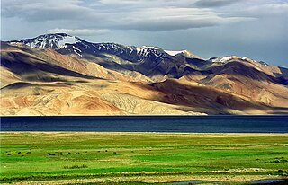
The Alpine-steppe is a high altitude natural alpine grassland, which is a part of the Montane grasslands and shrublands biome.

The Sanetti Plateau is a major plateau of the Ethiopian Highlands, in the Oromia Region of Ethiopia. The plateau is the highest part of the Bale Mountains, and is located within Bale Mountains National Park.
The Karakoram-West Tibetan Plateau alpine steppe is a montane grasslands and shrublands ecoregion found in parts of Pakistan, China, Afghanistan, and India.

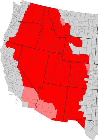
The Great Basin montane forests is an ecoregion of the Temperate coniferous forests biome, as designated by the World Wildlife Fund (WWF).

Montane ecosystems are found on the slopes of mountains. The alpine climate in these regions strongly affects the ecosystem because temperatures fall as elevation increases, causing the ecosystem to stratify. This stratification is a crucial factor in shaping plant community, biodiversity, metabolic processes and ecosystem dynamics for montane ecosystems. Dense montane forests are common at moderate elevations, due to moderate temperatures and high rainfall. At higher elevations, the climate is harsher, with lower temperatures and higher winds, preventing the growth of trees and causing the plant community to transition to montane grasslands and shrublands or alpine tundra. Due to the unique climate conditions of montane ecosystems, they contain increased numbers of endemic species. Montane ecosystems also exhibit variation in ecosystem services, which include carbon storage and water supply.

The Ruwenzori-Virunga montane moorlands is a montane grasslands and shrublands ecoregion of the Rwenzori Mountains and Virunga Mountains in central Africa.

The Northern Andean páramo (NT1006) is an ecoregion containing páramo vegetation above the treeline in the Andes of Colombia and Ecuador. In the past, when the climate was cooler, the treeline and the páramo units were lower and the units were connected. During the present warmer Holocene epoch the páramos have migrated uphill, shrinking and becoming isolated. They contain many rare or endangered species, some of them restricted to a narrow area of one mountain or mountain range. The ecoregion is relatively well preserved, but faces threats from over-grazing and farming.

The Santa Marta páramo (NT1007) is an ecoregion containing páramo vegetation above the treeline in the Sierra Nevada de Santa Marta mountain range on the Caribbean coast of Colombia. The isolated position of the range has allowed unique species to evolve. Some are related to those found in Central America and the Caribbean coastal areas, and some to species from the Andes. The habitat is relatively stable, but has been drastically changed from the original by long-term human activity.

The Cordillera Central páramo (NT1004) is an ecoregion containing páramo vegetation above the treeline in the Andes mountain range of northern Peru and southern Ecuador. Due to its isolation there are high levels of endemism. Despite many human settlements and some destruction of habitat by agriculture and mining, the ecoregion is relatively intact.
