Alpine tundra is a type of natural region or biome that does not contain trees because it is at high elevation. As the latitude of a location approaches the poles, the threshold elevation for alpine tundra gets lower until it reaches sea level, and alpine tundra merges with polar tundra.

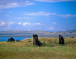
Katun Nature Reserve is a Russian zapovednik located in the highlands of the central Altai Mountains of south Siberia. The Katun River runs down through a valley in the reserve, serving as the primary source of the Ob River. The headwaters of the Katun River originate on Mount Belukha, the highest mountain in Siberia at 4,506 metres (14,783 ft), which is located on the far eastern edge of the preserve. Katun is an internationally important center of biodiversity, forming part of the "Golden Mountains of Altai" UNESCO World Heritage Site. Katun Nature Reserve is situated in the Ust-Koksinsky District of Altai Republic.
The Southern Siberian rainforest is an area of temperate rainforest in South Central Siberia that occurs primarily along the Altai and Sayan mountain ranges in Khakassia and Tuva as well as a small area in the Khamar-Daban Mountains near Lake Baikal in Buryatia. The forest encompasses a total area of approximately 6,000 square kilometres (2,300 sq mi). The larger portion of the forest in the Altai and Sayan Mountains runs across a latitude range that encompasses between 51.5 degrees to 56 degrees north latitude, and a longitude range running between 86 degrees to 95 degrees east longitude. The region overlaps with the Golden Mountains of Altai World Heritage Site. Ecological zones range from hemiboreal forest to a forest-steppe ecotone and include a wider variety of plant species than surrounding areas.

Saylyugemsky National Park sits at the mountainous "X" where the borders of Russia, Kazakhstan, Mongolia and China meet in the Altai Mountains of central Asia. Because of its remoteness and position at the meeting points of mountains, steppes, desert and forest, it is a globally important natural reserve for biodiversity. The park was formally established in 2010–2012, with a particular purpose of protecting the vulnerable Altai argali mountain sheep and the endangered Snow leopard. The component Saylyugem Mountains are a ridge of the Altai, and stretch to the northeast to the Sayan Mountains. The climate is cold and semi-arid. Administratively, the park is located in the Kosh-Agachsky District of the Altai Republic. While ecotourism has a stated role, visits to the territory currently require special passes from park administration, and activities are limited to roads and trails.

Shushensky Bor National Park consists of two representative forests in the extreme southwest of Siberia, in the northern foothills of the Western Sayan Mountains. The northern section is forest-steppe in character, while the southern section is mountain conifer forest. The southern section is bordered on two sides by the Yenisei river reservoir behind the Sayano-Shushenskaya Dam, the largest hydroelectric dam in Russia. The forest has both high biodiversity value and recreational value for hikers and tourists. It is located in the Shushensky District of Krasnoyarsk Krai.

Azas Nature Reserve is a Russian 'Zapovednik', located in the central part of the Todzha basin of south-central Asia about 500 km west of Lake Baikal. The reserve stretches along the Azas River, and is situated in the Todzhinsky District of Tuva.

Kabardino-Balkarski Nature Reserve is a Russian 'zapovednik' on main ridge of the north Caucasus Mountains. It contains all of the mountains in Europe over 5,000 meters besides Mt. Elbrus and Mt. Kazbek, and contains the most glaciers. The ridge at the reserve forms the famous "Bezengi wall" consisting of the peaks Gestola, Katyn-Tau, Janga, Eastern Jangi-Tau and Shkhara. There are 256 glaciers in the reserve's boundaries. The reserve is situated in the Chereksky District of Kabardino-Balkar Republic; it was created in 1976, and covers an area of 82,507 ha (318.56 sq mi).
Khakasski Nature Reserve is a Russian 'zapovednik' covering two large mountain areas, and a cluster of seven steppe sites located within the left bank of the Minusinsk depression. The reserve is situated in the Tashtypsky District of Khakassia. It was originally created to preserve steppe ecosystems, wetlands and waterfowl nesting sites, and a historical complex of monuments and cemeteries from the 4-11 centuries BC. The reserve is particularly noted for its variety of large lakes on the Yenisei River migration route for birds. The current configuration of protected sectors was established in 1999, and covers a total area of 267,483 ha (1,032.76 sq mi).

Kuznetsk Alatau Nature Reserve is a Russian 'zapovednik' on the Kuznetsk Alatau, a mountain ridge in the Altai-Sayan mountain region in southwestern Siberia. The Kuznetsk Alatau consists of several ranges of medium height, between which there are river valleys. The reserve is in the watershed of the Tom River and the Chuly River. It is spread over three districts of Kemerovo Oblast: Tisulsky District, Mezhdurechensky District, and Novokuznetsky District. The reserve was established in 1989 and covers an area of 412,900 ha (1,594 sq mi).

Tigirekskiy Nature Reserve is a Russian 'zapovednik' in the northwest mid-level mountains of the Altai-Sayan region. The reserve was established for the protection and study of the relic pre-glacial dark taiga of the higher elevations, and the mountain-steppe of the river valleys and lower regions. The site features extensive karst landscape and caves. The reserve is situated in the Zmeinogorsky, Tretyakovsky and Krasnoshchyokovsky districts of Altai Krai. It was formally established in 1999, and covers a total area of 40,693 ha (157.12 sq mi).

Katon-Karagay National Park is the largest national park in Kazakhstan, located on the eastern edge of the country, in the Southern Altai Mountains. The park fills the west side of the "X" where the borders of Kazakhstan, Russia, China, and Mongolia meet. The highest peak in Siberia, is on the Russian border in the Katun Range. The park is in Katonkaragay District of East Kazakhstan Region, 1,000 kilometres (620 mi) southeast of the capital city of Astana.

The Altai montane forest and forest steppe ecoregion covers patches of the subalpine forest belt on the Altai Mountains, crossing the border region where Russia, Kazakhstan, Mongolia and China meet. The region has high biodiversity, as it is located in transition zones between different ecoregions, altitudes, and climate zones. It is in the Palearctic realm, with a Cold semi-arid climate. It covers 35,199,998 km2 (13,590,795 sq mi).

The Sayan montane conifer forests ecoregion covers the mid-elevation levels of the Sayan Mountains, the high mountain range between the taiga of Siberia, Russia to the north, and the steppes of Mongolia to the south. The slopes of the mountains at the mid-altitudes are covered by Temperate coniferous forest. The ecoregion is in the Palearctic realm, with a cold semi-arid climate. It covers 35,741,835 km2 (13,800,000 sq mi).
The Kazakh forest steppe ecoregion is a long thin strip of transition zone between the forested taiga of Siberian Russia, and the Kazakh steppe to the south. The ecoregion stretches over 2,000 km from the southern Ural mountains in the west to the foothills of Altai mountains in the east, yet averages only 200 km from south to north across its length. Because the region is farther inland than European forest steppe, and some 300 to 500 km farther north, the climate is more continental and with less precipitation the tree cover more sparse. The ecoregion is in the Temperate grasslands, savannas, and shrublands biome, and the Palearctic realm, with a Humid Continental climate. It covers 420,614 km2 (162,400 sq mi).

The Sayan intermontane steppe ecoregion is sometimes referred to as a "steppe island", being an expanse of grassland and shrubs surrounded by mountain forests in the Tyva Republic of south central Siberia, Russia. The Altai Mountains are to the west, the Sayan Mountains to the north, and the Tannu-Ola Mountains to the south. The ecoregion is in the temperate grasslands, savannas, and shrublands biome, and the Palearctic realm, with a Humid Continental climate. For much of its length, it follows the course of the upper Yenisei River. It covers 33,928 km2 (13,100 sq mi).

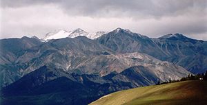
The Altai alpine meadow and tundra ecoregion is a terrestrial ecoregion covering the higher elevation of the Altai Mountains at the center of the "X" formed by the borders separating Russia, Kazakhstan, China, and Mongolia. The mountain peaks are the farthest north in Central Asia, separating the plains of Siberia to the north from the hot, dry deserts to the south. Altitudes above 2,400 meters display characteristics of tundra, with patches of alpine meadows and some trees immediately below the treeline. The ecoregion is in the montane grasslands and shrublands biome, and the Palearctic realm, with a humid continental climate. It covers an area of 90,132 square kilometres (34,800 sq mi).

The Cherskii–Kolyma mountain tundra ecoregion is an ecoregion that covers the higher elevations of the Chersky Range and the Kolyma Mountains, the only large mountain range in northern Russia. It is in the Palearctic realm, and tundra biome. It has an area of 556,589 square kilometres (214,900 sq mi).

The Kamchatka Mountain tundra and forest tundra ecoregion is an ecoregion that covers the central mountain range of the Kamchatka Peninsula in the Russian Far East. The region is one of volcanos, caldera, geysers, and mountain tundra. It is in the Palearctic realm and tundra biome. It has an area of 119,400 square kilometres (46,100 sq mi).

The Kola Peninsula tundra ecoregion is an ecoregion that covers the northeastern half of the Kola Peninsula, along the coast of the White Sea, a marginal sea of the Arctic Ocean. The maritime effects of the White Sea create a milder climate than would be expected for a region of this latitude. It is in the Palearctic realm, and the tundra biome. It has an area of 58,793 square kilometres (22,700 sq mi).

The Trans-Baikal Bald Mountain tundra ecoregion covers the high-altitude peak zones above the treeline in a series of mountain ranges that stretch from the northern reaches of Lake Baikal to the western coastal ranges of the Okhotsk Sea. Floral communities are those of mountain tundra, with bare rock or permafrost under layers of moss and lichen. Because the ecoregion is aligned along a common latitude, it acts as a route for the transmission of species across Siberia. The ecoregion is in the Palearctic realm and the tundra biome. It has an area of 217,559 square kilometres (84,000 sq mi).