The following is a list of ecoregions in Mongolia, according to the Worldwide Fund for Nature (WWF):

Mongolia is a landlocked country in Central Asia and East Asia, located between China and Russia. The terrain is one of mountains and rolling plateaus, with a high degree of relief. The total land area of Mongolia is 1,564,116 square kilometres. Overall, the land slopes from the high Altai Mountains of the west and the north to plains and depressions in the east and the south. The Khüiten Peak in extreme western Mongolia on the Chinese border is the highest point. The lowest point is at 560 m (1,840 ft), is the Hoh Nuur or lake Huh. The country has an average elevation of 1,580 m (5,180 ft).

The Altai Mountains, also spelled Altay Mountains, are a mountain range in Central and East Asia, where Russia, China, Mongolia and Kazakhstan converge, and where the rivers Irtysh and Ob have their headwaters. The massif merges with the Sayan Mountains in the northeast, and gradually becomes lower in the southeast, where it merges into the high plateau of the Gobi Desert. It spans from about 45° to 52° N and from about 84° to 99° E.
The Global 200 is the list of ecoregions identified by the World Wide Fund for Nature (WWF), the global conservation organization, as priorities for conservation. According to WWF, an ecoregion is defined as a "relatively large unit of land or water containing a characteristic set of natural communities that share a large majority of their species dynamics, and environmental conditions". For example, based on their levels of endemism, Madagascar gets multiple listings, ancient Lake Baikal gets one, and the North American Great Lakes get none.
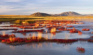
Uvs Lake Basin is an endorheic basin located on the territorial border of Mongolia and Tuva, a republic of the Russian Federation. The basin is part of the Central Asian Internal Drainage Basin and is named after Uvs Lake, a large saline lake situated in the western part of its drainage basin and is one of the last remnants of the mammoth steppes. Uvs Lake is a shallow lake with an area of 3,350 km2 (1,290 sq mi). Its entire basin, which includes several smaller lakes, is 70,000 km2 (27,000 sq mi).

The wildlife of Mongolia consists of unique flora and fauna in 3092.75 habitats dictated by the diverse and harsh climatic conditions found in the country. Then the north, salty marshes, fresh-water sources, desert steppes at the centre, and semi deserts, as well as the hot Gobi desert in the south, the fifth largest desert in the world.
The Southern Siberian rainforest is an area of temperate rainforest in South Central Siberia that occurs primarily along the Altai and Sayan mountain ranges in Khakassia and Tuva as well as a small area in the Khamar-Daban Mountains near Lake Baikal in Buryatia. The forest encompasses a total area of approximately 6,000 square kilometres (2,300 sq mi). The larger portion of the forest in the Altai and Sayan Mountains runs across a latitude range that encompasses between 51.5 degrees to 56 degrees north latitude, and a longitude range running between 86 degrees to 95 degrees east longitude. The region overlaps with the Golden Mountains of Altai World Heritage Site. Ecological zones range from hemiboreal forest to a forest-steppe ecotone and include a wider variety of plant species than surrounding areas.

The Tunka or Tunkinsky National Park is a national park located in south central Siberia. It covers a mountainous region centered on the Irkut River valley that continues from the rift valley of Lake Baikal southwest to the border of Mongolia. To the north and west of the valley is the eastern edge of the Sayan Mountains. To the east are the lower Khamar-Daban mountains. About 1,183,662 hectares in size, the park occupies the entirety of the Tunkinsky District of the Republic of Buryatia.

Saylyugemsky National Park sits at the mountainous "X" where the borders of Russia, Kazakhstan, Mongolia and China meet in the Altai Mountains of central Asia. Because of its remoteness and position at the meeting points of mountains, steppes, desert and forest, it is a globally important natural reserve for biodiversity. The park was formally established in 2010–2012, with a particular purpose of protecting the vulnerable Altai argali mountain sheep and the endangered Snow leopard. The component Saylyugem Mountains are a ridge of the Altai, and stretch to the northeast to the Sayan Mountains. The climate is cold and semi-arid. Administratively, the park is located in the Kosh-Agachsky District of the Altai Republic. While ecotourism has a stated role, visits to the territory currently require special passes from park administration, and activities are limited to roads and trails.
Shushensky Bor National Park consists of two representative forests in the extreme southwest of Siberia, in the northern foothills of the Western Sayan Mountains. The northern section is forest-steppe in character, while the southern section is mountain conifer forest. The southern section is bordered on two sides by the Yenisei river reservoir behind the Sayano-Shushenskaya Dam, the largest hydroelectric dam in Russia. The forest has both high biodiversity value and recreational value for hikers and tourists. It is located in the Shushensky District of Krasnoyarsk Krai.

Azas Nature Reserve is a Russian 'Zapovednik', located in the central part of the Todzha basin of south-central Asia about 500 km west of Lake Baikal. The reserve stretches along the Azas River, and is situated in the Todzhinsky District of Tuva.

Kuznetsk Alatau Nature Reserve is a Russian 'zapovednik' on the Kuznetsk Alatau, a mountain ridge in the Altai-Sayan mountain region in southwestern Siberia. The Kuznetsk Alatau consists of several ranges of medium height, between which there are river valleys. The reserve is in the watershed of the Tom River and the Chuly River. It is spread over three districts of Kemerovo Oblast: Tisulsky District, Mezhdurechensky District, and Novokuznetsky District. The reserve was established in 1989 and covers an area of 412,900 ha (1,594 sq mi).

The Altai montane forest and forest steppe ecoregion covers patches of the subalpine forest belt on the Altai Mountains, crossing the border region where Russia, Kazakhstan, Mongolia and China meet. The region has high biodiversity, as it is located in transition zones between different ecoregions, altitudes, and climate zones. It is in the Palearctic realm, with a Cold semi-arid climate. It covers 35,199,998 km2 (13,590,795 sq mi).

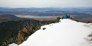
The Sayan montane conifer forests ecoregion covers the mid-elevation levels of the Sayan Mountains, the high mountain range between the taiga of Siberia, Russia to the north, and the steppes of Mongolia to the south. The slopes of the mountains at the mid-altitudes are covered by Temperate coniferous forest. The ecoregion is in the Palearctic realm, with a cold semi-arid climate. It covers 35,741,835 km2 (13,800,000 sq mi).

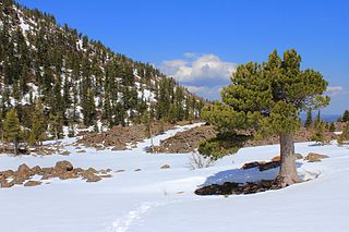
The Altai alpine meadow and tundra ecoregion is a terrestrial ecoregion covering the higher elevation of the Altai Mountains at the center of the "X" formed by the borders separating Russia, Kazakhstan, China, and Mongolia. The mountain peaks are the farthest north in Central Asia, separating the plains of Siberia to the north from the hot, dry deserts to the south. Altitudes above 2,400 meters display characteristics of tundra, with patches of alpine meadows and some trees immediately below the treeline. The ecoregion is in the montane grasslands and shrublands biome, and the Palearctic realm, with a humid continental climate. It covers an area of 90,132 square kilometres (34,800 sq mi).
The Khangai Mountains alpine meadows ecoregion runs along the central ridge of the Khangai Mountains in central Mongolia. The slopes to the north are conifer forests, the lowlands to the south are semi-arid steppe. The Khangai are an "island" mountain range surrounded by lower forest steppe and semi-arid regions of central Mongolia. Most of the region is now protected by Tarvagatai Nuruu National Park and Khangai Nuruu National Park.