
Mongolia is a landlocked country in East Asia, located between China and Russia. The terrain is one of mountains and rolling plateaus, with a high degree of relief. The total land area of Mongolia is 1,564,116 square kilometres. Overall, the land slopes from the high Altai Mountains of the west and the north to plains and depressions in the east and the south. The Khüiten Peak in extreme western Mongolia on the Chinese border is the highest point. The lowest point is at 560 m (1,840 ft), is the Hoh Nuur or lake Huh. The country has an average elevation of 1,580 m (5,180 ft).

The Bayankhongor Province or Bayanhongor Aimag is one of the 21 aimags (provinces) of Mongolia. It is located in the southwest of the country and, at 116,000 square kilometers, it is one of the largest aimags. The capital of the aimag shares the provincial name, Bayankhongor.
Bayan-Ovoo is a sum (district) of Ömnögovi Province in the Gobi Desert of southern Mongolia. The seat lies at Erdenetsogt.

The Valley of the Lakes is an intermontane depression located in southwestern Mongolia, separating the Khangai and Govi-Altai mountains. The valley stretches 500 km long, has a width of approximately 100 km, and is located at altitudes ranging between 1000 and 1400 meters above sea level. The topography is dominated by sandy and rocky plains, with solonchak and takir soils present. Along the valley floor lies a chain of large and small saline lakes, which are generally shallow, with a saucer-shaped depth profile. The largest of these lakes are Böön Tsagaan Lake and Orog Lake. Water levels vary considerably in size both seasonally and from year to year, and some lakes may dry out completely in certain years. They all receive their inflow from rivers which rise in the Khangai Mountains, and no permanent inflow comes from the Gobi-Altai. Barchan sand dunes are located on the valley's margins. The region near the Govi-Altai is a seismically active zone and is where the 1957 Mongolia earthquake occurred.

Rostov Nature Reserve is a Russian 'zapovednik' that protects a variety of sensitive southern European steppe wetlands, the largest herd of wild horses in Europe, and also wetland habitat for birds. The protected areas are divided into five sections that cover the waters of Lake Manych-Gudilo, islands in that lake, surrounding steppe and shore lands. The reserve is situated in the Orlovsky District, of Rostov Oblast, about 100 km northeast of Rostov-on-Don. It is part of a Ramsar Wetland site of international importance.

The Altai montane forest and forest steppe ecoregion covers patches of the subalpine forest belt on the Altai Mountains, crossing the border region where Russia, Kazakhstan, Mongolia and China meet. The region has high biodiversity, as it is located in transition zones between different ecoregions, altitudes, and climate zones. It is in the Palearctic realm, with a Cold semi-arid climate. It covers 35,199,998 km2 (13,590,795 sq mi).

The Daurian forest steppe ecoregion is a band of grassland, shrub terrain, and mixed forests in northeast Mongolia and the region of Siberia, Russia that follows the course of the Onon River and Ulz River, and part of the northwestern China. The region has been described as a "sea of grass that forms the best and most intact example of an undisturbed steppe ecosystem and is also one of the last areas in the Palearctic that still supports stable herds of larger vertebrates" in a semi-mountainous area. The area also has flat wetlands that are important to migratory birds. The ecoregion is in the Palearctic realm, with a dry-winter subarctic climate that borders on a very cold semi-arid climate (BSk) in its southwestern parts. It covers 209,012 km2 (80,700 sq mi).

The Selenge–Orkhon forest steppe ecoregion stretches across north central Mongolia, and follows the Selenga River northeast into Russia. The ecoregion is itself at high elevations, but surrounded by higher mountain ranges. As a transition zone between taiga and steppe, it features conifer forests on the north slopes of mountains, and pine/aspen stands on southern slopes. It has an area of 227,660 square kilometres (87,900 sq mi).

The Great Lakes Basin desert steppe ecoregion covers the enclosed basin centered on Uvs Lake, a saline, endorheic basin in northwestern Mongolia. A portion of the ecoregion stretches across the region into Russia. The lake district is important for migrating birds, waterfowl, and seabirds. The ecoregion is in the Palearctic realm and the deserts and xeric shrublands biome. It has an area of 157,212 square kilometres (60,700 sq mi).

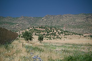
The Alashan Plateau semi-desert ecoregion covers the southwestern portion of the Gobi Desert where precipitation in the mountains is sufficient for a short part of the summer to support sparse plant life. The terrain is basin and range, with elevations from 1,000 to 2,500 metres. The region straddles the China–Mongolian border, with the Tibetan Plateau to the south, and the more arid regions of the Gobi to the north and east.

The Yarlung Tsangpo arid steppe ecoregion covers the river valley of the Yarlung Tsangpo River on the southern edge of Tibet. The river runs parallel to the northern borders of Nepal, Bhutan and India, between the Himalayas to the south and the Tibet Plateau to the north. The river valleys are the most populated areas of Tibet, putting pressure on wildlife. The area ranges from cold desert in the west to steppe shrub land in the east; the few trees are in the lowest river valleys to the east.

The Altai steppe and semi-desert ecoregion, as its name indicates, sits in a transition zine between steppe and semi-desert, supporting sparse grass and shrublands. The area is relatively undeveloped, with agriculture mostly represented by grazing livestock. There are a few shallow lakes in depressions used by migratory birds.
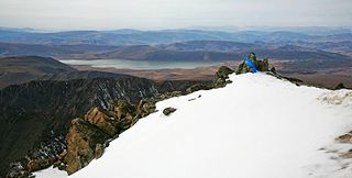
The Khangai Mountains alpine meadows ecoregion runs along the central ridge of the Khangai Mountains in central Mongolia. The slopes to the north are conifer forests, the lowlands to the south are semi-arid steppe. The Khangai are an "island" mountain range surrounded by lower forest steppe and semi-arid regions of central Mongolia. Most of the region is now protected by Tarvagatai Nuruu National Park and Khangai Nuruu National Park.

The Khangai Mountains conifer forests ecoregion covers the northern slopes of the Khangai Mountains in central Mongolia. The montane taiga supports a populations of elk, deer, wild boar, wolves, and brown bear. The diversity of plants and animals has benefited from the relative isolation and low human population of the area.

Khangai Nuruu National Park stretches in a west-to-east band across the middle of the Khangai Mountains, with the eastern half following the upper Orkhon River valley. There are a variety of habitat types in the park: steppe, riparian forests, larch taiga, and alpine meadows.
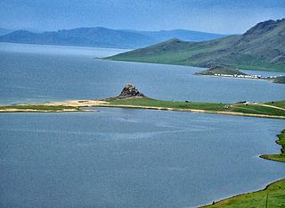
Khorgo-Terkhiin Tsagaan Nuur National Park covers the picturesque Terkhiin Tsagaan Lake and the nearby Khorgo Mountain in the north central Khangai Mountains in Arkhangai Province, Mongolia. The marshes along the west end of the lake are an important breeding and staging area for birds. The park is located in Tariat District of Arkhangai Province.
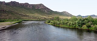
Onon-Balj National Park covers two sectors of the Onon River valley as it flows north from Mongolia into Russia. The region is in the transition zone between the Siberian conifer forests of the north and the Daurian steppe and forest steppe of Mongolia. The area is one of relatively high biodiversity, and is also historically and culturally important for its association with Genghis Khan. The park is located in the far northeast of Khentii Province, 280 km northeast of Ulaanbaatar.

Khar Us Nuur National Park is a national park in Khovd Province, Mongolia. It covers a chain of three large lakes in the Great Lakes Basin of western Mongolia. The lakes, Khar-Us Nuur, Khar Lake and Dörgön Lake are bordered by marshes and reed-beds that are an important breeding sport for birds, over 200 species of which have been identified in the park. Mount Jargalant is on the southern shore of Khar-Us. This park is distinct from Khyargas Nuur National Park, another large lake in the region, but 60 km to the north.
The Middle East steppe ecoregion stretches in an arc from southern Jordan across Syria and Iraq to the western border of Iran. The upper plains of the Tigris and Euphrates Rivers dominate most of the ecoregion. The terrain is mostly open shrub steppe. The climate is arid. Evidence is that this region was once more of a forest-steppe, but centuries of overgrazing and gathering firewood have reduced tree and grass cover to small areas and along the riverine corridors. Despite the degraded condition of the steppe environment, the ecoregion is important for water birds as the rivers and reservoirs provide habitat in the arid region.


