Central Afghan Mountains xeric woodlands

Last updated
Central Afghan Mountains xeric woodlands
Aerial view of Charikar in Parwan Province near Panjshir.jpg
Ecoregion PA1309.png
Ecoregion territory (in purple)
Ecology
Realm Palearctic
Biome Deserts and xeric shrublands
Geography
Area139,709 km2 (53,942 sq mi)
Country Afghanistan
Coordinates 32°15′N67°45′E / 32.25°N 67.75°E / 32.25; 67.75

The Central Afghan Mountains xeric woodlands ecoregion (WWF ID: PA1309) covers the xeric (dry) eastern and southern slopes of the central mountain range of Afghanistan, between the sandy desert to the south and the alpine meadows in the higher, wetter region to the north. [1] [2] [3] Despite the 'woodlands' in the ecoregion name, very little of the territory is forested – less than 1% – but is instead sparse vegetation or herbaceous cover. [3]

Contents

Location and description

The central mountain ranges of the Afghanistan are western extensions of the Hindu Kush mountains in the northeast of the country. These subranges center on the Koh-i-Baba (Baba Mountain Range) the Koh-e Paghman Mountains. The mean elevation is 2,058 metres (6,752 ft), with a highest peak being Kuh-e Kokzaro Zaghicha 5,125 metres (16,814 ft) [4] at the northeastern extreme of the ecoregion. [3]

Climate

The climate of the ecoregion is Humid continental climate - Hot, dry summer sub-type (Köppen climate classification Dsa), with large seasonal temperature differentials and a hot summer (at least one month averaging over 22 °C (72 °F), and mild winters. The driest month between April and September does not have more than 30 millimeters of precipitation. [5] [6]

Flora

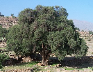
According to satellite analysis, 65% of the ecoregion is bare or sparse vegetation, and another 27% is "herbaceous cover". There are communities of wild pistachio trees ( Pistacia atlantica ) at altitudes of 1,150-1,800 meters. Precipitation at these altitudes averages 250-400 mm/year. Higher, at 2,000-2,800 meters, Almond trees of genus Prunus mark a transition zone to the higher sub-alpine vegetation. [7]

Fauna

Of conservation interest in the ecoregion is the critically endangered Paghman mountain salamandar ( Afghanodon mustersi ). A large saline lake, Ab-i Istada in the ecoregion, is an important migratory stop in the Spring for waterfowl traveling between Siberia and the Ganges Plain of India. The site has a significant breeding population of American flamingos ( Phoenicopterus ruber ). [8]

Protected areas

There are no protected areas in this ecoregion. [3]

Related Research Articles

<span class="mw-page-title-main">Southeast Tibet shrub and meadows</span> Ecoregion in the Tibetan Plateau

The Southeast Tibet shrub and meadows are a montane grassland ecoregion that cover the southeast and eastern parts of the Tibetan Plateau in China. The meadows in this region of Tibet are in the path of the monsoon rains and are wetter than the other upland areas of the Tibetan Plateau. The "high cold" alpine terrain is one of high species diversity, due to the relatively high levels of precipitation for the region. Precipitation is lower in the northwest, and hence the vegetation thins from shrub to meadow or even desert.

<span class="mw-page-title-main">Pamir alpine desert and tundra</span> Ecoregion in the Pamir Mountains

The Pamir alpine desert and tundra ecoregion covers the high plateau of the Pamir Mountains, at the central meeting of the great mountain ranges of Central Asia: Himalaya, Karakoram, Hindu Kush, Kunlun, and Tian Shan. It is a region of relatively high biodiversity due to its central location and high elevation differentials, but it also acts as a barrier between the climate and habitats of north and south Asia.

<span class="mw-page-title-main">Central Tibetan Plateau alpine steppe</span> Ecoregion in the Tibetan Plateau

The Central Tibetan Plateau alpine steppe ecoregion covers the high alpine plateau that stretches over 1,600 kilometres (1,000 mi) across the Tibetan Plateau to Qinghai Lake in China. Because of the high altitude—much it over 5,000 metres (16,000 ft)—the region is a cold, arid desert that is only 20% covered with steppe and meadow vegetation. The area has been relatively free from human development due to the hostile climate and unsuitability for agriculture. The ecosystem is relatively intact, and supports herds of wild antelope, sheep, deer, and gazelles.

<span class="mw-page-title-main">Khangai Mountains alpine meadow</span> National park in Mongolia

The Khangai Mountains alpine meadows ecoregion runs along the central ridge of the Khangai Mountains in central Mongolia. The slopes to the north are conifer forests, the lowlands to the south are semi-arid steppe. The Khangai are an "island" mountain range surrounded by lower forest steppe and semi-arid regions of central Mongolia. Most of the region is now protected by Tarvagatai Nuruu National Park and Khangai Nuruu National Park.

<span class="mw-page-title-main">Kopet Dag semi-desert</span> Ecoregion in Turkmenistan and Iran

The Kopet Dag semi-desert ecoregion is a small ecoregion that crosses the border of southwestern Turkmenistan into northeastern Iran. It covers a transition zone between the deserts to the north and west, and the foothill steppes and woodlands in the higher Kopet Dag mountains to the east and the Alborz Mountains to the south. The terrain is mostly barren semi-desert and widespread 'takir', a type of seasonal salt flat or dried clay deposit in an interdune depression.

<span class="mw-page-title-main">Alai–Western Tian Shan steppe</span>

The Alai-Western Tian Shan steppe ecoregion covers the foothills on the western edge of the Tien Shan and Alay Mountains of Central Asia. This territory is mostly in southeastern Uzbekistan, with a portion running north into Kazakhstan on the east side of the Syr Darya River, and a small portion in Turkmenistan.

<span class="mw-page-title-main">East Afghan montane conifer forests</span> Ecoregion on the Afghanistan-Pakistan border

The East Afghan montane conifer forests ecoregion covers a series of unconnected conifer forests along the border between Afghanistan and Pakistan, at elevations of 2,000 metres (6,600 ft) to 3,400 metres (11,200 ft) above sea level. The ecoregion supports the near-threatened Markhor (Capra falconeri chiltanensis), known as the Screw-horned goat, the national animal of Pakistan. The forests of the ecoregion have been heavily thinned for timber.
<span class="mw-page-title-main">Afghan Mountains semi-desert</span> Ecoregion in Afghanistan

The Afghan Mountains semi-desert ecoregion covers three disconnected interior valleys in the north of the mountains of Afghanistan. These valleys are arid, and covered mostly in thorny shrubs. Overgrazing by livestock has put pressure on the grasses and the wild animals dependent on them.

<span class="mw-page-title-main">Ghorat–Hazarajat alpine meadow</span>

The Ghorat-Hazarajat alpine meadow ecoregion covers the high mountainous elevations of central Afghanistan. The ecoregion fans out to the west from the capital city of Kabul at the eastern point. Vegetation is thornbush meadows and alpine grassland. The region is the home of the critically endangered Afghan brook salamander, which depends on the cold waters of the high streams of the ecoregion.

<span class="mw-page-title-main">Kuh Rud and Eastern Iran montane woodlands</span>

The Kuh Rud and Eastern Iran montane woodlands ecoregion covers hills and mountains in central and eastern Iran. The habitat is wetter and cooler than the surrounding desert of the Iranian Plateau, supporting the vulnerable goitered gazelle and small populations of the cheetah. The ecoregion is under conservation threat from overgrazing and conversion of steep slopes to cultivation.

<span class="mw-page-title-main">Central Persian desert basins</span> Ecoregion in Iran and Afghanistan

The Central Persian desert basins ecoregion covers the arid steppe and desert basins of central Iran, stretching into northwestern Afghanistan. The ecoregion extends over the Central Iranian Plateau, which is surrounded by mountain ranges and has no outlets to the sea. Much of the terrain is hot sand-and-gravel desert and large salt flats. The vegetation includes many specialized species of halophytes (salt-tolerant), xerophytes (drought-tolerant), and psammophile (sand-loving) plants.

<span class="mw-page-title-main">Hindu Kush alpine meadow</span> Ecoregion primarily in Afghanistan

The Hindu Kush alpine meadow ecoregion covers a portion of the Hindu Kush Mountain Range in northern Afghanistan. Most of the terrain is between 3,000 and 4,000 meters in elevation. This portion of the Hindu Kush is very mountainous, with steep slopes. About half of the alpine meadow is bare rock or gravely soils with sparse vegetation. The remainder supports herbaceous cover of grasses and cushion plants. Human habitation is scarce and follows the river courses in the valleys.

<span class="mw-page-title-main">Red Sea Nubo–Sindian tropical desert and semi-desert</span>

The Red Sea Nubo–Sindian tropical desert and semi-desert ecoregion covers extremely arid land along the northeastern Red Sea, the southern Sinai Peninsula, and on a thin strip along the Israel-Jordan border. Most of the coastal land is flat, but there are high mountains in southern Sinai. Biodiversity is limited by the low moisture levels – some areas go for years without significant rain. Portions of the area support a thin savannah-like cover of widely scattered trees and scrub, surrounded by grasses that briefly flourish after a rainfall. Biodiversity is highest in the mountains of Sinai, and in the wadis and gullies that retain moisture.

<span class="mw-page-title-main">Paropamisus xeric woodlands</span> Ecoregion in Aghanistan and Tajikistan

The Paropamisus xeric woodlands ecoregion covers the portion of northeastern Afghanistan north of the central mountain range and the Hindu Kush Mountains. The name is derived from the Old Persian name for the region, Parupraesanna. While there are low canopy woodlands in the northeast of the ecorgegion, most of the territory is desert or xeric (dry) scrubland.

<span class="mw-page-title-main">Baluchistan xeric woodlands</span> Ecoregion in Pakistan and Afghanistan

The Baluchistan xeric woodlands ecoregion covers the middle elevations of a series of mountain ranges of western Pakistan and northeastern Afghanistan, reaching 1,200 kilometres (750 mi) from the Arabian Sea in the south to the Hindu Kush Mountains and the Himalayas in the north. The characteristic vegetation is xeric (dry) woodlands of shrubs and herbaceous cover. The region has rich biodiversity but relatively few endemic species.

<span class="mw-page-title-main">Sulaiman Range alpine meadows</span>

The Sulaiman Range alpine meadows ecoregion covers a series of higher altitude mountain ranges along the crest of the Sulaiman Mountains, a southerly extension of the Hindu Kush Mountains along the Afghanistan-Pakistan border. The area is relatively undeveloped, with about a third of the terrain either forested or in 'alpine steppe' shrub or herbaceous cover.

<span class="mw-page-title-main">Interior Yukon–Alaska alpine tundra</span>

The Interior Yukon-Alaska alpine tundra ecoregion covers alpine, sub-alpine, and boreal forest areas along the cordillera of Interior Alaska and south-central Yukon Territory. Geologically, they are the disjunct uplands of the Yukon-Tanana Terrane plus a southern extension of the Brooks Range. The cover is extensive 'dark taiga' of closed spruce forest, open forest of other species, and alpine vegetation at higher altitudes. The region is mostly wilderness and relatively untouched by human development.

<span class="mw-page-title-main">Ogilvie–MacKenzie alpine tundra</span> Tundra ecoregion of Canada and the United States

The Ogilvie–MacKenzie alpine tundra ecoregion covers the mountainous middle of the Yukon Territory in Canada, with extensions into the Northwest Territories. The vegetation is alpine and subalpine open forest of stunted spruce, fir and pine. The area is rugged but sections appear to have been unglaciated in the late Pleistocene and there are therefore relic species in the region. The area is remote and supports large, sustainable predator-prey systems.

<i>Juniperus seravschanica</i> Species of conifer

Juniperus seravschanica is a species of juniper. Common names include Pashtun juniper.

<span class="mw-page-title-main">Leeward Islands xeric scrub</span> Xeric shrubland ecoregion of the Leeward Islands

The Leeward Islands xeric scrub ecoregion covers the dry ('xeric'), non-forested areas of the Leeward Islands on the northeastern edge of the Caribbean Sea, stretching from the Virgin Islands in the west to Guadeloupe to the southeast. The non-forested areas are generally low scrub shrub, on the low elevations around the peripheries of the islands. Non-forested lower elevations in the region receive less rainfall and are typically semi-arid. A notable feature of the ecoregion is its position in the main hurricane track. The frequent damage to trees allows more pre-climax shrubs and trees to grow. There are a number of endemic species, as in common with islands.

References

  1. "Central Afghan Mountains xeric woodlands". World Wildlife Federation. Retrieved March 21, 2020.
  2. "Map of Ecoregions 2017". Resolve, using WWF data. Retrieved September 14, 2019.
  3. 1 2 3 4 "Central Afghan Mountains xeric woodlands". Digital Observatory for Protected Areas. Retrieved August 1, 2020.
  4. "Kuh-e Kokzaro Zaghicha". Peakbagger. Retrieved October 17, 2020.
  5. Kottek, M.; Grieser, J.; Beck, C.; Rudolf, B.; Rubel, F. (2006). "World Map of Koppen-Geiger Climate Classification Updated" (PDF). Gebrüder Borntraeger 2006. Retrieved September 14, 2019.
  6. "Dataset - Koppen climate classifications". World Bank. Retrieved September 14, 2019.
  7. "National Biodiversity Strategy & Action Plan" (PDF). Islamic Republic of Afghanistan. Retrieved October 17, 2020.
  8. "Ab-i-Istada". Birdlife International. Retrieved October 17, 2020.