Paropamisus xeric woodlands

Last updated
Paropamisus xeric woodlands
Kunduz (4325431032).jpg
Ecoregion PA1322.jpg
Ecoregion territory (in purple)
Ecology
Realm Palearctic
Biome Deserts and xeric shrublands
Geography
Area92,804 km2 (35,832 sq mi)
Country Afghanistan, Tajikistan
Coordinates 36°15′N66°45′E / 36.25°N 66.75°E / 36.25; 66.75

The Paropamisus xeric woodlands ecoregion (WWF ID: PA1322) covers the portion of northeastern Afghanistan north of the central mountain range and the Hindu Kush Mountains. The name is derived from the Old Persian name for the region, Parupraesanna ("Beyond the Hindu Kush"). While there are low canopy woodlands in the northeast of the ecorgegion, most of the territory is desert or xeric (dry) scrubland. [1] [2] [3] [4]

Contents

Location and description

The ecoregion stretches for 1,100 kilometres (680 mi) across northern Afghanistan, from the city of Herat in the west to the Wakhan Corridor in the east. The territory is on the north slopes of the mountains of central Afghanistan and the Hindu Kush. To the north is the Badghyz and Karabil semi-desert ecoregion, to the south are the Ghorat-Hazarajat alpine meadow and Hindu Kush alpine meadow ecoregions.

The terrain is rugged: elevations range from 371 metres (1,217 ft) to a high point of 5,592 metres (18,346 ft). [3]

Climate

The climate of ecoregion is Cold semi-arid climate (Köppen climate classification (BSk)). This climate is characteristic of steppe climates intermediary between desert humid climates, and typically have precipitation is above evapotranspiration. At least one month averages below 0 °C (32 °F). [5] [6]

Flora and fauna

Over 80% of the ecoregion is dry shrub. Another 8% is cultivated in crop agriculture (mostly along river valleys), and another 8% is sparse vegetation or bare ground. [3] Common vegetation is thornbush, Ziziphus ( Ziziphus nummularia and Ziziphus spina-christi ), Acacia ( Vachellia tortilis and Vachellia flava ) Pistacia atlantica , Larix griffithii, Pinus roxburghii, Pinus hwangshanensis, Juniperus tibetica, Shorea robusta, Olea europaea subsp. cuspidata, Tsuga dumosa, Taxus sumatrana, Betula utilis, Alnus nepalensis, Betula alnoides, Betula utilis, Picea brachytyla, Juglans regia, Larix gmelinii, Larix sibirica, Larix × czekanowskii, Betula dahurica, Betula pendula, Pinus koraiensis, Pinus sibirica, Pinus sylvestris, Picea obovata, Abies sibirica, Quercus acutissima, Quercus mongolica, Ginkgo biloba, Prunus serrulata, Prunus padus, Tilia amurensis, Salix babylonica, Acer palmatum, Populus tremula, Ulmus davidiana, Ulmus pumila, Pinus pumila, Haloxylon ammodendron, Elaeagnus angustifolia, Tamarix ramosissima , Prunus sibirica , Cathaya argyrophylla , Taiwania cryptomerioides , Cyathea spinulosa , Sassafras tzumu , Davidia involucrata , Metasequoia glyptostroboides , Glyptostrobus pensilis , Castanea mollissima , Quercus myrsinifolia , Quercus acuta , Machilus thunbergii , Tetracentron , Cercidiphyllum japonicum , Emmenopterys henryi , Eucommia ulmoides , Olea europaea , Balanites aegyptiaca , Cupressus sempervirens , Salix alba , Populus nigra , Quercus coccifera , Quercus ilex , Quercus pubescens , Pistacia terebinthus , Pinus pinea , Pinus nigra , Ceratonia siliqua , Arbutus unedo , Erica arborea , Laurus nobilis , Prosopis cineraria , Pinus halepensis , Toona ciliata , Aerva javanica , Prunus amygdalus , Juniperus communis , Quercus brantii , Quercus robur , Quercus petraea , Picea abies , Abies alba , Alnus glutinosa , Fagus sylvatica , Taxus baccata , Acer pseudoplatanus , Malus sylvestris , Viburnum lantana , Fraxinus excelsior , Tilia cordata , Aesculus hippocastanum , Rhamnus cathartica , Ulmus glabra , Ulmus minor , Populus alba , and Corylus avellana . There are areas of woodland in the northeast of the ecoregion in Badakhshan Province, featuring wild almond, pistachio, willow, and buckthorn trees. [4] There are no endemic vertebrates, but the isolated areas support a range of non-endemic threatened and endangered species, including the near threatened Argali ( Ovis ammon ), the vulnerable Goitered gazelle ( Gazella subgutturosa ), the endangered Kulan ( Equus hemionus ), the near threatened Mountain weasel ( Mustela altaica ), and near threatened Sand cat ( Felis margarita ). [4]

Protected areas

Less than 1% of the ecoregion is officially protected. [3] [7] These protected areas include the Dashti-Jum Nature Reserve in Tajikistan.

Related Research Articles

<span class="mw-page-title-main">Eastern Highlands moist deciduous forests</span> Ecoregion of India

The Eastern Highlands moist deciduous forests, presently known as East Deccan moist deciduous forests, is a tropical and subtropical moist broadleaf forests ecoregion in east-central India. The ecoregion covers an area of 341,100 square kilometers (131,700 sq mi), extending across portions of Andhra Pradesh, Chhattisgarh, Jharkhand, Madhya Pradesh, Maharashtra, Odisha, and Telangana states.

<span class="mw-page-title-main">Caucasus mixed forests</span> Ecoregion

The Caucasus mixed forests is a temperate broadleaf and mixed forests ecoregion in the Caucasus Mountains, as well as the adjacent Lesser Caucasus range and the eastern end of the Pontic Mountains.

<span class="mw-page-title-main">Crimean Submediterranean forest complex</span>

The Crimean Submediterranean forest complex is an ecoregion on the Black Sea coast of Russia and Ukraine. It is in the temperate broadleaf and mixed forests biome.

<span class="mw-page-title-main">North Saharan steppe and woodlands</span> Ecoregion in North Africa

The North Saharan steppe and woodlands is a desert ecoregion, in the deserts and xeric shrublands biome, that forms the northern edge of the Sahara. It extends east and west across Northern Africa, south of the Mediterranean dry woodlands and steppe ecoregion of the Maghreb and Cyrenaica, which is part of the Mediterranean forests, woodlands, and scrub biome. Winter rains sustain shrublands and dry woodlands that form an ecotone between the Mediterranean climate regions to the north and the hyper-arid Sahara Desert ecoregion to the south.

<span class="mw-page-title-main">Mediterranean dry woodlands and steppe</span> Mediterranean forests, woodlands, and scrub ecoregion of North Africa

The Mediterranean dry woodlands and steppe is a Mediterranean forests, woodlands, and scrub ecoregion of North Africa. It occupies interior plateaus and mountain ranges of the Maghreb region, lying generally between the coastal Mediterranean woodlands and forests to the north and the Sahara to the south.

<span class="mw-page-title-main">Illyrian deciduous forests</span> Terrestrial ecoregion of Europe

The Illyrian deciduous forests is a terrestrial ecoregion in southern Europe, which extends along the eastern coast of the Adriatic Sea. It belongs to the Mediterranean forests, woodlands, and scrub biome, and is in the Palearctic realm.

<span class="mw-page-title-main">Italian sclerophyllous and semi-deciduous forests</span> Ecoregion in Italy

The Italian sclerophyllous and deciduous forests ecoregion, part of the Mediterranean forests, woodlands, and scrub biome, is in Italy. The ecoregion covers most of the Italian Peninsula and includes both evergreen and deciduous forests.

<span class="mw-page-title-main">Tyrrhenian–Adriatic sclerophyllous and mixed forests</span> Ecoregion in Southern Europe

The Tyrrhenian-Adriatic sclerophyllous and mixed forests is an ecoregion in southern Italy, Sicily, Sardinia, Corsica, the Dalmatian Islands of Croatia, and Malta.

<span class="mw-page-title-main">Tugay</span> Riparian gallery forest habitats in central Asia

Tugay is a form of riparian forest or woodland associated with fluvial and floodplain areas in arid climates. These wetlands are subject to periodic inundation, and largely dependent on floods and groundwater rather than directly from rainfall. Tugay habitats occur in semi-arid and desert climates in Central Asia. Because Tugay habitat is usually linear, following the courses of rivers in arid landscapes, Tugay communities often function as wildlife corridors. They have disappeared or become fragmented over much of their former range.

<span class="mw-page-title-main">Eastern Anatolian montane steppe</span>

The Eastern Anatolian montane steppe is a temperate grasslands, savannas, and shrublands ecoregion. It is located in the Armenian Highlands, covering parts of eastern Turkey, Armenia, Azerbaijan, southern Georgia, and northwestern Iran.

<span class="mw-page-title-main">Qionglai–Minshan conifer forests</span> Ecoregion in Southwestern China

The Qionglai-Minshan conifer forests are a World Wide Fund for Nature ecoregion in Southwest China. These forests are classified as temperate coniferous forests and are part of the Palearctic realm.

<span class="mw-page-title-main">Qilian Mountains conifer forests</span> Ecoregion in the Tibetan Plateau

The Qilian Mountains Conifer Forests ecoregion is an ecoregion that consists of a series of isolated conifer forests on the northern slopes of the Qilian Mountain Range, on the northeast edge of the Tibetan Plateau in Qinghai and Gansu provinces of north-central China.

<span class="mw-page-title-main">Tian Shan montane conifer forests</span> Ecoregion in the Tian Shan Mountains

The Tian Shan montane conifer forests ecoregion covers the "forest belt" of the Tian Shan mountains - generally the north-facing slopes that get enough moisture, and are warm enough, for trees to grow. This conifer belt is found mostly between 1,500 and 2,700 meters.

<span class="mw-page-title-main">Tian Shan foothill arid steppe</span> Ecoregion in the Tian Shan Mountains

The Tian Shan foothill arid steppe ecoregion covers the northern and western approaches to the Tian Shan mountains, centered on Lake Issyk-Kul in Kyrgyzstan. This region receives more moisture from Central Asia, thereby supporting more vegetation and diversity of plant and animal species than the deserts to the south.

<span class="mw-page-title-main">Central Asian riparian woodlands</span>

The Central Asian riparian woodlands ecoregion is spread out across the deserts and plains of central Asia between the Aral Sea and the mountains 2,000 kilometres (1,200 mi) to the east. The long narrow components of the ecoregion follow the large rivers fed by snowmelt, and provide critical habitat for migratory birds as they travel through the arid region. The vegetation is referred to as tugai, characterized by low tangles of trees and brush along the edges of the rivers and associated wetlands, and fed by groundwater instead of precipitation.

<span class="mw-page-title-main">Gissaro–Alai open woodlands</span>

The Gissaro-Alai open woodlands ecoregion covers the western foothills winding around two western offshoots of the Tian Shan Mountains in western Tajikistan, and parts of eastern Uzbekistan and western Kyrgyzstan, in Central Asia. The woodlands are typically of Juniper trees and shrubs, fitting the altitude zone situated between the desert valley floor, and the tree line, above which the mountain ridges are glaciated and barren.

<span class="mw-page-title-main">East Afghan montane conifer forests</span> Ecoregion on the Afghanistan-Pakistan border

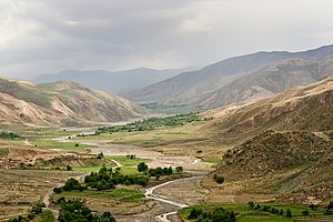
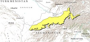
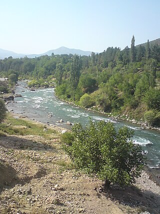
The East Afghan montane conifer forests ecoregion covers a series of unconnected conifer forests along the border between Afghanistan and Pakistan, at elevations of 2,000 metres (6,600 ft) to 3,400 metres (11,200 ft) above sea level. The ecoregion supports the near-threatened Markhor (Capra falconeri chiltanensis), known as the Screw-horned goat, the national animal of Pakistan. The forests of the ecoregion have been heavily thinned for timber.

<span class="mw-page-title-main">Azerbaijan shrub desert and steppe</span> Ecoregion in western Asia

The Azerbaijan shrub desert and steppe is a deserts and xeric shrublands ecoregion in western Asia. It lies in the lowlands west of the Caspian Sea, and covers portions of Azerbaijan, Georgia, and Iran.

<span class="mw-page-title-main">Central Afghan Mountains xeric woodlands</span> Ecoregion in Afghanistan

The Central Afghan Mountains xeric woodlands ecoregion covers the xeric (dry) eastern and southern slopes of the central mountain range of Afghanistan, between the sandy desert to the south and the alpine meadows in the higher, wetter region to the north. Despite the 'woodlands' in the ecoregion name, very little of the territory is forested – less than 1% – but is instead sparse vegetation or herbaceous cover.

<span class="mw-page-title-main">Baluchistan xeric woodlands</span> Ecoregion in Pakistan and Afghanistan

The Baluchistan xeric woodlands ecoregion covers the middle elevations of a series of mountain ranges of western Pakistan and northeastern Afghanistan, reaching 1,200 kilometres (750 mi) from the Arabian Sea in the south to the Hindu Kush Mountains and the Himalayas in the north. The characteristic vegetation is xeric (dry) woodlands of shrubs and herbaceous cover. The region has rich biodiversity but relatively few endemic species.

References

  1. "Paropamisus xeric woodlands". World Wildlife Federation. Retrieved March 21, 2020.
  2. "Map of Ecoregions 2017". Resolve, using WWF data. Retrieved September 14, 2019.
  3. 1 2 3 4 "Paropamisus xeric woodlands". Digital Observatory for Protected Areas. Retrieved August 1, 2020.
  4. 1 2 3 "Paropamisus xeric woodlands". The Encyclopedia of Earth. Retrieved August 28, 2020.
  5. Kottek, M.; Grieser, J.; Beck, C.; Rudolf, B.; Rubel, F. (2006). "World Map of Koppen-Geiger Climate Classification Updated" (PDF). Gebrüder Borntraeger. Retrieved September 14, 2019.
  6. "Dataset - Koppen climate classifications". World Bank. Retrieved September 14, 2019.
  7. Dinerstein, Eric [in German]; Olson, David; Joshi, Anup; et al. (2017-04-05). "An Ecoregion-Based Approach to Protecting Half the Terrestrial Realm". BioScience . 67 (6): 534–545, Supplemental material 2 table S1b. doi: 10.1093/biosci/bix014 . ISSN   0006-3568. PMC   5451287 . PMID   28608869.