
Cape Verde is a group of arid Atlantic islands which are home to distinct communities of plants, birds, and reptiles. The islands constitute the unique Cape Verde Islands dry forests ecoregion, according to the World Wildlife Fund.

Morocco is the northwesternmost country which spans from the Mediterranean Sea and Atlantic Ocean on the north and the west respectively, into large mountainous areas in the interior, to the Sahara desert in the far south. Morocco is a Northern African country, located in the extreme northwest of Africa on the edge of continental Europe. The Strait of Gibraltar separates Spain from Morocco with a 13 kilometres (8.1 mi) span of water. Morocco borders the North Atlantic Ocean to the west, and the western Mediterranean Sea to the north, and has borders with Algeria and disputed Western Sahara.

At 824,292 km2 (318,261 sq mi), Namibia is the world's thirty-fourth largest country. After Mongolia, Namibia is the second least densely populated country in the world. Namibia got its name from the Namib desert that stretches along the coast of the Atlantic. It is also known for its wildlife.

The Sahara desert, as defined by the World Wide Fund for Nature (WWF), includes the hyper-arid center of the Sahara, between latitudes 18° N and 30° N. It is one of several desert and xeric shrubland ecoregions that cover the northern portion of the African continent.

Western Sahara is a territory in Northern Africa, bordered by the North Atlantic Ocean, Morocco proper, Algeria, and Mauritania. Geographic coordinates: 24°30′N13°00′W

Mauritania, a country in the Western Region of the continent of Africa, is generally flat, its 1,030,700 square kilometres forming vast, arid plains broken by occasional ridges and clifflike outcroppings. Mauritania is the world’s largest country lying entirely below an altitude of 1,000 metres (3,300 ft). It borders the North Atlantic Ocean, between Senegal and Western Sahara, Mali and Algeria. It is considered part of both the Sahel and the Maghreb. A series of scarps face southwest, longitudinally bisecting these plains in the center of the country. The scarps also separate a series of sandstone plateaus, the highest of which is the Adrar Plateau, reaching an elevation of 500 metres or 1,640 feet. Spring-fed oases lie at the foot of some of the scarps. Isolated peaks, often rich in minerals, rise above the plateaus; the smaller peaks are called Guelbs and the larger ones Kedias. The concentric Guelb er Richat is a prominent feature of the north-central region. Kediet ej Jill, near the city of Zouîrât, has an elevation of 915 metres or 3,002 feet and is the highest peak.

Mali is a landlocked nation in West Africa, located southwest of Algeria, extending south-west from the southern Sahara Desert through the Sahel to the Sudanian savanna zone. Mali's size is 1,240,192 square kilometers.

The Sahel region or Sahelian acacia savanna is a biogeographical region in Africa. It is the transition zone between the more humid Sudanian savannas to its south and the drier Sahara to the north. The Sahel has a hot semi-arid climate and stretches across the southernmost latitudes of North Africa between the Atlantic Ocean and the Red Sea. Although geographically located in the tropics, the Sahel does not have a tropical climate.

The Sahara is a desert spanning across North Africa. With an area of 9,200,000 square kilometres (3,600,000 sq mi), it is the largest hot desert in the world and the third-largest desert overall, smaller only than the deserts of Antarctica and the northern Arctic.
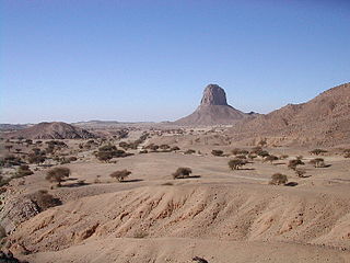
The West Saharan montane xeric woodlands is an ecoregion that extends across several highland regions in the Sahara. Surrounded at lower elevations by the largely barren Sahara, the West Saharan montane xeric woodlands are isolated refuges of plants and animals that can survive in the higher humidity and lower temperatures of the highlands.
Mauritania's wildlife has two main influences as the country lies in two biogeographic realms. The north sits in the Palearctic which extends south from the Sahara to roughly 19° north latitude and the south is in the Afrotropic realm. Additionally, Mauritania is an important wintering area for numerous birds which migrate from the Palearctic.
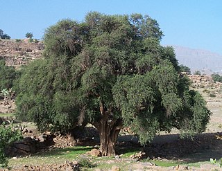
The Mediterranean Acacia–Argania dry woodlands and succulent thickets is a Mediterranean forests, woodlands, and scrub ecoregion in North Africa centered mainly on Morocco but also including northwestern Western Sahara and the eastern Canary Islands.

The North Saharan steppe and woodlands is a desert ecoregion, in the deserts and xeric shrublands biome, that forms the northern edge of the Sahara. It extends east and west across Northern Africa, south of the Mediterranean dry woodlands and steppe ecoregion of the Maghreb and Cyrenaica, which is part of the Mediterranean forests, woodlands, and scrub biome. Winter rains sustain shrublands and dry woodlands that form an ecotone between the Mediterranean climate regions to the north and the hyper-arid Sahara Desert ecoregion to the south.
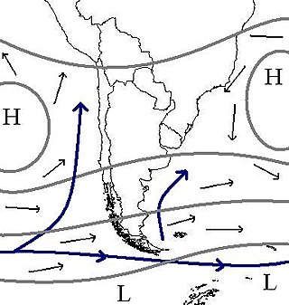
The climate of Chile comprises a wide range of weather conditions across a large geographic scale, extending across 38 degrees in latitude, making generalizations difficult. According to the Köppen system, Chile within its borders hosts at least seven major climatic subtypes, ranging from low desert in the north, to alpine tundra and glaciers in the east and southeast, tropical rainforest in Easter Island, Oceanic in the south and Mediterranean climate in central Chile. There are four seasons in most of the country: summer, autumn, winter, and spring.

The Mediterranean woodlands and forests is an ecoregion in the coastal plains, hills, and mountains bordering the Mediterranean Sea and Atlantic Ocean in North Africa. It has a Mediterranean climate, and is in the Mediterranean forests, woodlands, and scrub biome.

The South Saharan steppe and woodlands, also known as the South Sahara desert, is a deserts and xeric shrublands ecoregion of northern Africa. This band is a transitional region between the Sahara's very arid center to the north, and the wetter Sahelian Acacia savanna ecoregion to the south. In pre-modern times, the grasslands were grazed by migratory gazelles and other ungulates after the rainfalls. More recently, over-grazing by domestic livestock have degraded the territory. Despite the name of the ecoregion, there are few 'woodlands' in the area; those that exist are generally acacia and shrubs along rivers and in wadis.

The Tibesti-Jebel Uweinat montane xeric woodlands is a deserts and xeric shrublands ecoregion in the eastern Sahara. The woodlands ecoregion occupies two separate highland regions, covering portions of northern Chad, southwestern Egypt, southern Libya, and northwestern Sudan.

The West Sudanian savanna is a tropical savanna ecoregion that extends across West Africa.

The Southwestern Arabian foothills savanna, also known as the Southwestern Arabian Escarpment shrublands and woodlands, is a desert and xeric shrubland ecoregion of the southern Arabian Peninsula, covering portions of Saudi Arabia, Yemen, and Oman.

The Red Sea coastal desert is deserts and xeric shrublands ecoregion of Egypt and Sudan.

