Kunduz,[a][b] also written as Qunduz, is a city in northern Afghanistan, serving as the capital of Kunduz Province. It is within the jurisdiction of Kunduz District and has an estimated population of 413,996 people as of September 2025.[2] Mawlavi Gul Mohammad Elyas is the mayor of the city.[3]
Kunduz is also sometimes spelled (romanized) as Kundûz, Qonduz, Qondûz, Konduz, Kondûz, Kondoz, or Qhunduz. The name of the city is believed to have derived from the Persian compound, kohan dež, "old/ancient fort".[5]
Kunduz is located in the northern part of Afghanistan, near southern Tajikistan. It is at an altitude of 351m (1,152ft) above sea level and surrounded by vast farmlands. Kunduz is a strategic city that connects many other Afghan cities and towns. It is administratively divided into about 8 city districts ('nahias') with a total land area of 112km2 (43sqmi) or 11,206ha (27,690 acres).[1]
Land use of the city (within the municipal boundary) is largely agricultural (65.8% of total area). Residential land comprises nearly half of the 'built-up' land area (48.3%) with 29,877 dwellings. Institutional land comprises 17.9% of built-up land use, given that the airport is within the municipal boundary.[1]
Kunduz is believed to be the site of the ancient city of Drapsaka. It was a great centre of Buddhist learning and very prosperous during the 3rd century AD.[citation needed]
The city used to be called Aornos (Bactrian: οαρνο, romanized:warn)[7] and later Walwalij[8] or Varvaliz, a compound of the old name Warn and Bactrian: λιζο, romanized:lizo, lit.'fortress'.[9] The name Kuhandiz began to be used from the time of the Timurid Empire, before the 16h century.
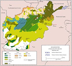
In the early 20th century, between 100 and 200,000 Tajiks and Uzbeks fled the conquest of their homeland (now southern Tajikistan) by the SovietRed Army and settled in northern Afghanistan.[12]
In the early 20th century, under the governance of Sher Khan Nashir, Kunduz became one of the wealthiest Afghan provinces. This was mainly due to Nasher's founding of the Spinzar Cotton Company, which is state-owned and still operational to the present day.[13] At its peak, the Spinzar Cotton Company employed 5,000 people full time. Kunduz is the most important agricultural province which produces wheat, rice, millet, and other products and obtained the nickname of "the hive of the country."[14]
Kunduz is the center for the northeast provinces and was captured by the Taliban in 1997. It was the last major city held by the Taliban before its fall to US-backed Afghan Northern Alliance forces on 26 November 2001. NATO forces killed over 100 civilians in the 2009 Kunduz airstrike. During the summer of 2015, the Taliban advanced and attacked the city, which resulted in a battle for control of the city against US-funded Afghan Armed Forces. Tens of thousands of inhabitants were displaced internally by the fighting.[15][16][17] On 28 September 2015 the Taliban flag was again raised in the city center and the Taliban managed to capture the city prison and free many prisoners.[18][19] On 3 October 2015, a United States Air ForceAC-130U gunship attacked the Kunduz Trauma Centre operated by Médecins Sans Frontières (MSF, or Doctors Without Borders). The US-backed Afghan forces counter-attacked and managed to re-capture the city in 15 days. The Taliban announced that, after achieving their objectives, they have withdrawn from the city's center. Zabiullah Mujahid, a Taliban spokesperson, said that their main object in leaving the city is to avoid civilian casualties from air raids.[20] In April 2018 the Afghan Air Force conducted an airstrike that killed and injured dozens of civilians at a religious school in Kunduz.[21] On 31 August 2019, the Taliban forces launched another attack on the city, setting off a major battle with local security forces.
On 19 May 2020, the Taliban killed one policeman and one civilian and injured 18 others in a motorbike bomb blast in Kunduz. On the same day, the Taliban attempted to re-capture Kunduz, attacking several government posts but were repelled by the Afghan security forces. The Taliban were forced to flee the city, leaving ten dead bodies behind. Eight Afghan soldiers and three civilians were killed and 55 others were wounded during the Taliban attack.[22]
The Arabs of Kunduz speak Dari and Pashto, Afghanistan's two official languages, rather than Arabic. However, they claim a strong Arab identity, based on their tribal origins in the Arabian Peninsula. This may point to the seventh-century and later migration to this area of many Arab tribes, especially in the wake of the Muslim conquests of Afghanistan.[29]
↑"Kunduz Province"(PDF). Program for Culture & Conflict Studies. Naval Postgraduate School. Archived from the original(PDF) on 2 October 2012. Retrieved 12 January 2014.
↑"2003 National Geographic Population Map"(PDF). Thomas Gouttierre, Center For Afghanistan Studies, University of Nebraska Omaha; Matthew S. Baker, Stratfor. National Geographic Society. 2003. Archived from the original(PDF) on 27 February 2008. Retrieved 18 June 2017.
This page is based on this Wikipedia article Text is available under the CC BY-SA 4.0 license; additional terms may apply. Images, videos and audio are available under their respective licenses.