Puli Khumri,[a] also written as Pul-i-Khumri or Pol-e Khomri, is a city in northern Afghanistan, serving as the capital of Baghlan Province.[5][6] It is within the jurisdiction of Puli Khumri District and has an estimated population of 230,112 people.[4]Maulvi Abdul Latif Mazlom is the current mayor of the city.[1] His predecessor was Maulvi Mohammad Anwar Mustaqeem.[7]
During the 1980s, Puli Khumri was officially granted the status of the capital of Baghlan province in place of the central city of Baghlan. This transition occurred under the influence of Sayed Mansur Naderi, son of Sayed Kayan, who held significant military and political power at the time.[8] The relocation aimed to enhance public access to administrative offices, leveraging Puli Khumri's strategic location along the Kabul-Mazar highway. The cabinet of Mohammad Najibullah, led by Sultan Ali Keshtmand, initially proposed this move through declaration number 492 on March 1, 1989. It was subsequently formalized by Najibullah through decree number 1603 on March 9, 1989.[9]
From August 8-10, 1988, there were fires and explosions in the 3704th Ammunition Depot of the 40th Army (Soviet Union), located in the Kelgai Valley near the town.[10] The detonation of the explosives storage facility, according to eyewitnesses, resembled a nuclear one with the appearance of a characteristic nuclear "mushroom cloud". Eight soldiers and one civilian cook may have been killed, with others wounded. Western sources reported that the Soviet Ministry of Foreign Affairs (Soviet Union) denied there had been any casualties.[11]
Taliban insurgents have been active in the Dand-e-Shahabuddin part of Puli Khumri since 2917.[13] On 5 May 2019, Taliban members stormed the city's police headquarters, killing 13 police.[14] On 1 September 2019, Taliban assaulted the city,[15] but were repelled by the Afghan Army. On 16 January 2021, the district's NDS chief Fazal Wakilzada was killed in a Taliban attack.[16]
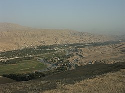
Puli Khumri is in a valley by the Kunduz River in northern Afghanistan, about 100km (60mi) south of Kunduz, 200km (120mi) southeast of Mazar-i-Sharif, and 230km (140mi) north of Kabul. It sits at an elevation of approximately 920m (3,020ft) above sea level, within the Hindu Kush mountain range.
Puli Khumri has 6 city districts (nahias),[2] covering a land area of 181km2 (70sqmi) or 3,752ha (9,270 acres).[3] Agricultural lands accounted for the largest land use in the city (65%), with the majority of that land in Districts 3, 5, and 6. Districts 1 and 2 had the highest dwelling densities but District 5 is home to the most dwelling units. Puli Khumri has a diverse housing stock consisting of regular, irregular, and hillside houses as well as apartment buildings.[2]
Climate
Puli Khumri features a cool semi-arid climate (BSk) under the Köppen climate classification. The average temperature in Puli Khumri is 15.9°C or 60.6°F, while the annual precipitation averages 282mm or 11.10in.
July is the hottest month of the year with an average temperature of 28.5°C or 83.3°F. The coldest month January has an average temperature of 3.0°C or 37.4°F.
The economy of Puli Khumri is based on agriculture, trade, mining, transport, and textile production. There is at least one major textile factory in the city.[22] Agriculture is very important because of the rain and temperature; wheat, rice, and spices are the main crops. There are two dams in Puli Khumri, which provide the necessary electricity. Electrical transmission lines built from Puli Khumri bring a steady supply of electricity to Kabul.
Afghanistan's first cement factory, Ghori I Cement Factory, was built in 1954 in Puli Khumri with financial support from Czechoslovakia. A third plant is under construction since August 2025.[23] The limestone is mined from the hill behind the factory.[24]
There is a coal mine outside of the city in the village Kar-kar, but the production system is archaic.
↑Author: Hakimi, Aziz Ahmed. Title: Fighting for Patronage: American counterinsurgency and the Afghan Local Police. Publisher: University of London. Date: 23.07.2015. Access date: 04.04.2024.
↑Official Gadget of Ministry of Justice of Afghanistan Republic Government. (1989, July 6). Decree number 1603 of March 9, 1989 by Afghanistan President about transfer of Baghlan capital to Puli Khumri city and omission of Puli Khumri as a district in the administrative structure of the province. Retrieved April 5, 2024, from https://law.acku.edu.af/wp-content/uploads/2022/11/acku_risalah_knf2720_meem69_1368_n695_dari_title1.pdf
↑A team of authors. Volume 12. Chapter III "Soviet military chronology" // Soviet Armed Forces Review Annual / Ed. George M. Mellinger. — Academic International Press, 1993. — P. 60.
This page is based on this Wikipedia article Text is available under the CC BY-SA 4.0 license; additional terms may apply. Images, videos and audio are available under their respective licenses.