Namak Ab District

Last updated

Namak Ab District
Namak Ab District Map.svg
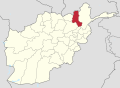
Location of Namak Ab in Takhar Province
Coordinates(District Center): 36°37′N69°37′E / 36.62°N 69.62°E / 36.62; 69.62 Coordinates: 36°37′N69°37′E / 36.62°N 69.62°E / 36.62; 69.62
CountryFlag of Afghanistan.svg  Afghanistan
Province Takhār Province
Area
[1]
  Total547.4 km2 (211.4 sq mi)
Population
 (2019) [2]
  Total13,579
  Density25/km2 (64/sq mi)
Time zone UTC+4:30 (Afghanistan Standard Time)

Namak Ab District is a district of Takhar Province, Afghanistan. The district was split-off from Taluqan District. In late 2018, Namak Ab was considered to be government influenced, as opposed to the Taliban. [1]

Contents

Geography

Namak Ab has an area of 547.4 square kilometers, comparatively equivalent to the area of San Cristóbal Island. [3] The only river in the district flows north until it reaches the Khanabad River. The district does not have good access to roads, with only 10% of the district having road access as of 2006. [4]

Namak Ab is bordered by Taluqan District to the north, Farkhar District to the east, Warsaj District to the southeast, Farang Wa Gharu District to the south, Guzargahi Nur District to the southwest, and Chal District to the west. Farang Wa Gharu and Guzargahi Nur are located in Baghlan Province, with all other districts located in Takhar Province. [5]

28 villages are located in Namak Ab. [4]

History

Namak Ab was created in June 2005 from Taluqan District. [6] It was cleared of insurgents in December 2018. [7]

The Taliban military chief for Namak Ab was captured in July 2020. [8]

A district administration complex was built in 2020, costing about 24,000,000 Afghani (about 310,000 USD). [9]

Demographics

The district has a population of 13579, with a sex ratio of 53 males for every 50 females. The median age is 16.7, and about 50% of the population is employed. About 20% of the unemployed are seeking work. Namak Ab has roughly 2500 households, with an average size of 5.4 people. The average household size is the lowest out of all the Takhar districts. [10]

Related Research Articles

Kunduz Province Province of Afghanistan

Kunduz or Qunduz is one of the 34 provinces of Afghanistan, located in the northern part of the country next to Tajikistan. The population of the province is around 953,800, which is mostly a tribal society; it is one of Afghanistan's most ethnically diverse provinces with many different ethnicities in large numbers living there. The city of Kunduz serves as the capital of the province. It borders the provinces of Takhar, Baghlan, Samangan and Balkh. The Kunduz Airport is located next to the provincial capital.

Takhar Province Province of Afghanistan

Takhar is one of the thirty-four provinces of Afghanistan, located in the northeast of the country next to Tajikistan. It is surrounded by Badakhshan in the east, Panjshir in the south, and Baghlan and Kunduz in the west. The city of Taloqan serves as its capital.

Districts of Afghanistan

This is a list of districts of Afghanistan, known as wuleswali. These are secondary level administrative units, one level below the provinces. The Afghan government issued its first district map in 1973. It recognized 325 districts, counting wuleswalis (districts), alaqadaries (sub-districts), and markaz-e-wulaiyat. In the ensuing years additional districts have been added through splits, and a few eliminated through mergers. In June 2005, the Afghan government issued a map of 398 districts. It was widely adopted as by many information management systems, though usually with the addition of Sharak-e-Hayratan for a 399 district total. Here is a link to a clean rendering of the 399 district set as a spreadsheet from an official Afghan source. It remains the de facto standard, as of late 2018, despite a string of government announcements of the creation of new districts.

Farang Wa Gharu District District in Baghlan Province, Afghanistan

Farang Gharu or Firing wa Gharu is a district in Baghlan Province, Afghanistan. It was created in 2005 from part of Khost wa Fereng District.

Dushi District District in Baghlan Province, Afghanistan

Dushi district is located in the central part of Baghlan Province, Afghanistan. It lies on the major Kabul-Kunduz highway. The population of the district was estimated to be around 57,160 in 2004. Hazaras are around 60% of the population and make up the majority in the district, followed by Tajiks (39%). The centre of the district is Dushi. Dushi was considered contested between the Afghan Government and the Taliban in late 2018.

Bangi District District in Takhār Province, Afghanistan

Bangi District is a district of Takhar Province, Afghanistan.

Chah Ab District District in Takhār Province, Afghanistan

Chah Ab District is a district of Takhar Province, Afghanistan. Its district center is Chah Ab. The district's economy is primarily based on agriculture and livestock. The district is considered to be under Taliban control.

Chal District District in Takhār, Afghanistan

Chal District is a district of Takhar Province, Afghanistan. It was considered to be largely under control of the Afghan government in 2018.

Darqad District District in Takhār Province, Afghanistan

Darqad District is a district of Takhar Province, Afghanistan. The district has 34 villages. Darqad did not change between the 325 and 398 district sets. Near the end of 2018, the district was considered to be Taliban-influenced, as opposed to the Afghan government.

Farkhar District District in Takhār Province, Afghanistan

Farkhar District is a district of Takhar Province, Afghanistan. It is located southeast of Taloqan. The Khanabad River flows inside this valley. Around 99% of the people in Farkhar speak Persian. Farkhar has about 50000 people and 75 villages.

Kalafgan District District in Takhār Province, Afghanistan

Kalafgan District is a district of Takhar Province, Afghanistan. The district is well governed, with self-governance in parts of Kalafgan because of how remote they are. 42 villages are located in the district. In 2017, Kalafgan was considered to be under full control by the Afghan Government.

Khwaja Ghar District District in Takhār Province, Afghanistan

Khwaja Ghar District is a district of Takhar Province, Afghanistan. The district was badly destroyed during the 1996-2001 Afghan Civil War in fighting between the Taliban and the Northern Alliance.

Rustaq District, Afghanistan District in Takhār Province, Afghanistan

Rustaq District is a district of Takhar Province, northern Afghanistan. The district centre is the town of Rostaq. As recently as 2020, the district was considered to be under government control, as opposed to control by the Taliban. However, the district has had issues with illegal armed men.

Warsaj District District in Takhār Province, Afghanistan

Warsaj District is a district of Takhar Province, northern Afghanistan.

Yangi Qala District District in Takhār Province, Afghanistan

Yangi Qala District is a district in Takhar Province, Afghanistan. Economically the population of this district is primarily involved in agriculture. The main crops are rice and wheat, and the surplus rice is exporting to neighboring districts and provinces. On September 10, 2019, the district was taken the Taliban. 3 days later, the district was of militants cleared in an operation. There are 64 villages in the district.

Baharak District, Takhar District in Takhār Province, Afghanistan

Baharak District is a district of Takhar Province, Afghanistan. The district was split-off from Taluqan District in 2005. Most people work in agriculture. The district has been the site of fighting between the Afghan Government and the Taliban; Baharak was considered to be contested in late 2018.

Dashti Qala District District in Takhār Province, Afghanistan

Dashti Qala District is a district of Takhar Province, Afghanistan. It split from Khwaja Ghar District in June 2005. This district borders Tajikistan. Ai-Khanoum, probably founded by the Seleucid Empire, is located in this district. In 2018, this district was considered contested between the government and the Taliban.

Hazar Sumuch District District in Takhār Province, Afghanistan

Hazar Sumuch District is a district of Takhar Province, Afghanistan. The district was split-off from Taluqan District. Most people in the district work in agriculture. In late 2018, Hazar Sumuch was considered to be government influenced as opposed to the Taliban.

Khwaja Bahauddin District District in Takhār Province, Afghanistan

Khwaja Bahauddin District is a district of Takhar Province, Afghanistan. The district was created from a portion of Yangi Qala District in 2005. 25 villages are located in Khwaja Bahauddin.

Aqtash District District in Kunduz, Afghanistan

Aqtash District is a district in Kunduz Province, Afghanistan. It was not part of the 399 or 407 district sets, but is recognized in the 422 district set as a temporary district. It was split from Khanabad District in late 2015 after a visit from Ashraf Ghani, the president of Afghanistan. The district is mostly under Taliban control, with only a few government-held areas. In 2019, only two polling centers were open in the district, with 277 votes cast.

References

  1. 1 2 "Appendices and Endnotes" (PDF). sigar.mil. 30 January 2019. p. 34. Retrieved 8 September 2020.
  2. "Population of Afghanistan 19-20" (PDF). nsia.gov.af. 2019. Archived from the original (PDF) on 9 June 2020. Retrieved 8 September 2020.
  3. "Islands by Land Area". islands.unep.ch. Archived from the original on 20 February 2018. Retrieved 8 September 2020.
  4. 1 2 "Namak Ab District Development Plan" (PDF). mrrd-nabdp.org. Archived from the original (PDF) on 4 March 2016. Retrieved 8 September 2020.
  5. "Afg: Takhar Province - Reference Map | HumanitarianResponse". www.humanitarianresponse.info. Retrieved 8 September 2020.
  6. "398 District Division Matching to 329 District Division". aims.org. Archived from the original on 22 March 2016. Retrieved 8 September 2020.
  7. "Namakab District, Takhar Province Clear From Insurgents". www.bakhtarnews.com.af. Retrieved 9 September 2020.
  8. "Taliban Commander Detained in Takhar Reporterly |". reporterly.net. Retrieved 9 September 2020.
  9. mudl_admin (10 March 2020). "Namak Ab District Administrative Complex Completed in Takhar | MUDL". w.mudl.gov.af. Retrieved 8 September 2020.
  10. "Takhar Socio-Demographic and Economic Survey". UNFPA Afghanistan. 5 January 2017. Retrieved 8 September 2020.