Khanashin District

Last updated

Khanashin
ریگ خان شین
District
FlagraisingatKhanNeshincastle.jpg
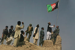
Flag raising over Khan Neshin castle, Rig District, after Operation Khanjar.
Afghanistan adm location map.svg
Red pog.svg
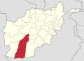
Khanashin
Location within Afghanistan [1]
Coordinates: 30°50′N63°29′E / 30.83°N 63.48°E / 30.83; 63.48
Country Flag of the Taliban.svg  Afghanistan
Province Helmand Province
Population
 (2012) [2]
  Total25,600

Reg (Khanashin) District is situated in the southeastern part of Helmand Province, Afghanistan along the Helmand River on its western bank. The population is 25,600 [2] (80% Pashtun and 20% Balouch). [3] The main village is Khanashin.

Contents

The district is almost a desert and all the villages are along the Helmand River. The drought has extremely affected this district and its agriculture is ruined. The unemployment rate is 80%.

Agriculture

Actually, the district is known as the "Green Zone" due to its abundance of vegetation. Due to irrigation controlled by the Helmand and Arghandab Valley Authority [4] the Helmand River feeds into many canals that wind through the surrounding villages and bring water to this once desolate area, allowing local farmers to grow crops ranging from corn, okra, wheat, poppy, and marijuana. The unemployment rate is below 20% due to the surge in American troops in the region, bringing much needed safety and stability, allowing locals to move back into the area and re-open once flourishing business.[ citation needed ]

History

Reg District was, for much of the Afghan War, under Taliban control, until it was taken by ISAF forces in July 2009 during Operation Khanjar.

Natural Resources

Geologists also discovered rare earth minerals and niobium deposits in the Khanneshin area of Southern Helmand province with an estimated value of more than $89 billion [5]

Related Research Articles

<span class="mw-page-title-main">Economy of Afghanistan</span> National economy

The economy of Afghanistan is listed as 103rd in the world in terms of gross domestic product (GDP) based on purchasing power parity (PPP). With a population of nearly 40 million people, Afghanistan's GDP (PPP) stands at around $77 billion with an exchange rate of $20 billion (2020), and the GDP (PPP) per capita is about $2,000. Its total external debt is 0 as of 2022. The Afghan economy continues to improve due to the influx of expats, improvement of national infrastructure, establishment of more trade routes with neighboring and regional countries, and expansion of the nation's agriculture and mining sectors.

<span class="mw-page-title-main">Helmand River</span> Major river in Afghanistan

The Helmand River is the longest river in Afghanistan and the primary watershed for the endorheic Sistan Basin. It emerges in the Sanglakh Range of the Hindu Kush mountains in the northeastern part of Maidan Wardak Province, where it is separated from the watershed of the Kabul River by the Unai Pass. The Helmand feeds into the Hamun Lake on the border between Afghanistan and Iran.

<span class="mw-page-title-main">Helmand Province</span> Province of Afghanistan

Helmand, also known as Hillmand, in ancient times, as Hermand and Hethumand, is one of the 34 provinces of Afghanistan, in the south of the country. It is the largest province by area, covering 58,584 square kilometres (20,000 sq mi) area. The province contains 13 districts, encompassing over 1,000 villages, and roughly 1,446,230 settled people. Lashkargah serves as the provincial capital. Helmand was part of the Greater Kandahar region until made into a separate province by the Afghan government in the 20th century.

<span class="mw-page-title-main">Badakhshan Province</span> Province of Afghanistan

Badakhshan Province is one of the 34 provinces of Afghanistan, located in the northeastern part of the country. It is bordered by Tajikistan's Gorno-Badakhshan in the north and the Pakistani regions of Lower and Upper Chitral and Gilgit-Baltistan in the southeast. It also has a 91-kilometer (57-mile) border with China in the east. It is currently contested between the NRF and the Taliban.

<span class="mw-page-title-main">Lashkargah</span> City in Nangarhar Province, Afghanistan

Lashkargāh, historically called Bost or Boost, is a city in southwestern Afghanistan and the capital of Helmand Province. It is located in Lashkargah District, where the Arghandab River merges into the Helmand River. The city has a population of 201,546 as of 2006. Lashkargah is linked by major roads with Kandahar to the east, Zaranj on the border with Iran to the west, and Farah and Herat to the north-west. It is mostly very arid and desolate. However, farming does exist around the Helmand and Arghandab rivers. Bost Airport is located on the east bank of the Helmand River, five miles north of the junction of the Helmand and Arghandab rivers. Because of the trading hubs, it is Afghanistan's second largest city in size, after Kabul and before Kandahar.

<span class="mw-page-title-main">Hamun Lake</span> Lake in Sistan and Baluchestan, Iran

Lake Hāmūn, or the Hamoun Oasis, is a seasonal lake and wetlands in the endorheic Sīstān Basin in the Sistan region on the Afghanistan–Iran border. In Iran, it is also known as Hāmūn-e Helmand, Hāmūn-e Hīrmand, or Daryācheh-ye Sīstān.

<span class="mw-page-title-main">Panjwayi District</span> District of Kandahar Province, southeastern Afghanistan

Panjwayi is a district in Kandahar Province, Afghanistan. It is located about 35 kilometres (22 mi) west of Kandahar. The district borders Helmand Province to the southwest, Maywand District to the west, Zhari District to the north, Arghandab, Kandahar and Daman districts to the east and Reg District to the south. Panjwayi was reduced in size in 2004 when Zhari District was created out of the northern part of it, on the northern side of the Arghandab River, which now forms the northern boundary.

Daman District is situated in the central part of the Kandahar Province, Afghanistan. It borders Panjwai and Kandahar districts to the west, Shah Wali Kot District to the north, Zabul Province to the northeast, Arghistan and Spin Boldak districts to the east and Reg District to the south. The population is 30,700 (2006). The center is the village of Daman, located in the central part of the district. The area is irrigated by the Helmand and Arghandab Valley Authority.

<span class="mw-page-title-main">Arghandab District, Kandahar</span> Settlement in Afghanistan

Arghandab is a district in the central part of Kandahar Province, Afghanistan. It borders Panjwai and Khakrez districts to the west, Shah Wali Kot District to the north and east and Kandahar District to the east and south.

Grishk District, also called Nahri Saraj District, is a district in Helmand Province in southern Afghanistan. Its principal municipality is Grishk. Grishk Dam is located in the district.

Dishu is a district in the south of Helmand Province, Afghanistan, bordering Pakistan. Its population, which is 80% Pashtun and 20% Baloch, was estimated at 19,900 in 2012. The district centre is the village of Dishu; most of the settlements in the district are along the Helmand River. The other important town is Bahramcha.

<span class="mw-page-title-main">Musa Qala District</span> District in Helmand Province, Afghanistan

Musa Qala is a district in the north of Helmand Province, Afghanistan. Its population was around 57,500 in 2012 and are 97% ethnic Pashtun. The district centre is the village of Musa Qala; there are 19 other large villages and 200 smaller settlements, mostly along the Musa Qala River. The area is irrigated by the Helmand and Arghandab Valley Authority.

<span class="mw-page-title-main">Nad Ali District</span> District in Helmand Province, Afghanistan

Nad Ali or Nad-e Ali is a district in Helmand Province, Afghanistan. Marja is an unincorporated agricultural district in Nad Ali. The area is irrigated by the Helmand and Arghandab Valley Authority (HAVA). A small town of the same name lies 11 km to the west of the Helmand River, at the coordinates shown at the top of the page. The town of Nad-e Ali was built in 1954 as part of the HAVA irrigation project, and was settled by 3,000 predominantly Pashtun families who were given newly arable land.

<span class="mw-page-title-main">Sangin District</span> District in Helmand Province, Afghanistan

Sangin is a district in the east of Helmand Province, Afghanistan. Its population was reported at 58,100 in 2012, all of which belong to Pashtun ethnic group. The district centre is the town of Sangin. The area is irrigated by the Helmand and Arghandab Valley Authority.

<span class="mw-page-title-main">Garmsir District</span> District in Helmand Province, Afghanistan

Garmsir District is located in the southern part of Helmand Province, Afghanistan. The district is large, but all the villages are along the Helmand River. The rest is a desert. The district capital, Garmsir, is located in the northwestern part of the district on the east bank of Helmand River.

Khanashin, or Khan Neshin, is a village located in the Reg District of Helmand Province, Afghanistan at 30.5494°N 63.7897°E at 642 altitude. It is close to the Helmand River and 168 km southwest of Lashkargah. It has been identified by the USGS as the site of a deposit, called the Khanneshin carbonatite, of at least 1 million tons of rare earth element ore.

<span class="mw-page-title-main">Helmand province campaign</span> 2006–2014 ISAF anti-Taliban military operations in southern Afghanistan

The Helmand province campaign was a series of military operations conducted by the International Security Assistance Force (ISAF) forces against Taliban insurgents and other local groups in the Helmand Province of Afghanistan. Their objective was to control a province that was known to be a Taliban stronghold, and a center of opium production. None of the ISAF's intended strategic and political objectives were achieved in the long term.

<span class="mw-page-title-main">Mining in Afghanistan</span> Overview of mining in Afghanistan

Mining in Afghanistan was controlled by the Ministry of Mines and Petroleum, prior to the August 15th takeover by the Taliban. It is headquartered in Kabul with regional offices in other parts of the country. Afghanistan has over 1,400 mineral fields, containing barite, chromite, coal, copper, gold, iron ore, lead, natural gas, petroleum, precious and semi-precious stones, salt, sulfur, lithium, talc, and zinc, among many other minerals. Gemstones include high-quality emerald, lapis lazuli, red garnet and ruby. According to a joint study by The Pentagon and the United States Geological Survey, Afghanistan has an estimated US$1 trillion of untapped minerals.

<span class="mw-page-title-main">Operation Strike of the Sword</span> 2009, US & UK v. Taliban, Afghanistan

Operation Strike of the Sword or Operation Khanjar was a US-led offensive in Helmand province in southern Afghanistan. About 4,000 Marines from the 2nd Marine Expeditionary Brigade as well as 650 Afghan troops were involved, supported by NATO planes. The operation began when units moved into the Helmand River valley in the early hours of July 2, 2009. This operation was the largest Marine offensive since the Battle of Fallujah in 2004. The operation was also the biggest offensive airlift by the Marines since the Vietnam War.

<span class="mw-page-title-main">Helmand and Arghandab Valley Authority</span> Agency of the Afghan government

The Helmand and Arghandab Valley Authority (HAVA) based in Lashkar Gah, Afghanistan, originally named the Helmand Valley Authority (HVA) until its expansion in 1965, was established on December 4, 1952, as an agency of the Afghan Government. The agency was modeled on the Tennessee Valley Authority in the United States, with a remit covering lands in Farah Province, Ghazni Province, Helmand Province, Herat Province, and Kandahar Province.

References

  1. "District Names". National Democratic Institute. Archived from the original on 29 January 2016. Retrieved 10 December 2015.
  2. 1 2 "Settled Population of Helmand Province" (PDF). Central Statistics Organization. Archived from the original (PDF) on 26 February 2014. Retrieved 10 December 2015.
  3. "District Profile" (PDF). UNHCR. Archived from the original (PDF) on 27 October 2005. Retrieved 10 December 2015.
  4. (pdf) The Helmand Valley Project in Afghanistan: A.I.D. Evaluation Special Study No. 18 C Clapp-Wicek & E Baldwin, U.S. Agency for International Development, published December 1983
  5. "U.S., Afghan Study Finds Mineral Deposits Worth $3 Trillion". Bloomberg. Retrieved 2 May 2022.