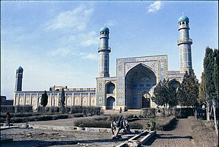
Herāt is an oasis city and the third-largest city in Afghanistan. In 2020, it had an estimated population of 574,276, and serves as the capital of Herat Province, situated south of the Paropamisus Mountains in the fertile valley of the Hari River in the western part of the country. An ancient civilization on the Silk Road between West Asia, Central Asia, and South Asia, it serves as a regional hub in the country's west.
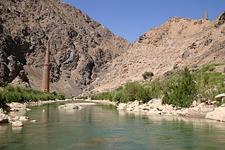
The Hari River or Herat River or Tejen River or Harirud is a river flowing 1,100 kilometres (680 mi) from the mountains of central Afghanistan to Turkmenistan, where it forms the Tejen oasis and disappears in the Karakum Desert. In its lower course, the river forms a northern part of the border between Afghanistan and Iran, and a southeastern part of the border between Turkmenistan and Iran.

Herat is one of the thirty-four provinces of Afghanistan, located in the western part of the country. Together with Badghis, Farah, and Ghor provinces, it makes up the north-western region of Afghanistan. Its primary city and administrative capital is Herat City. The province of Herat is divided into about 17 districts and contains over 2,000 villages. It has a population of about 3,780,000, making it the second most populated province in Afghanistan behind Kabul Province. The population is multi-ethnic but largely Persian-speaking. Herat dates back to the Avestan times and was traditionally known for its wine. The city has a number of historic sites, including the Herat Citadel and the Musalla Complex. During the Middle Ages Herat became one of the important cities of Khorasan, as it was known as the Pearl of Khorasan.

South Khorasan province is one of the 31 provinces of Iran, located in the eastern part of the country. Its capital is the city of Birjand. In 2014, the province was placed in Region 5.

Serhetabat is a city in Tagtabazar District, Mary Province, Turkmenistan. Serhetabat lies in the valley of the Kushk River. The population was 5,200 in 1991. It is immediately opposite Torghundi, Afghanistan, with which it is connected by a road and a 1,520 mm gauge railway.
The Kushk is a river which, for a portion of its course, forms the boundary between Afghanistan and Turkmenistan, and used to form part of the southernmost border of the Russian Empire and the Soviet Union. The Kushk is fed by the Aq Robat and Galleh Chagar rivers in north-western Afghanistan. After 150 km, it flows into the Murghab River.
Adraskan is a district in the central part of Herat Province in Afghanistan. It is bordered to the west by Iran, to the north by Ghoryan District, Zinda Jan District, Guzara District, Pashtun Zarghun District and Obe District, to the east by Farsi District and to the south by Shindand District.
Farsi is a district the west of Herat Province, Afghanistan. It borders on Obe District to the north, Adraskan District to the west, Shindand District to the south and Ghor Province to the south and east. The population was estimated at 29,800 in 2012. The district center is the village of Farsi.
The Ghurian District is an Afghan administrative district (Wuleswali) in far western Afghanistan in western Herat Province. The district is bordered by Iran to the west and northwest. It is then bordered by other districts of Herat, Kohsan District in the north, Zendeh Jan District to the east, and Adraskan District to the south. The Hari River flows through the northeastern end of the district. The border with Iran is marshy. The population is 85,900 and the district center is the city of Ghurian.
Gulran District is situated in northwestern part of Herat province, Afghanistan and borders Iran to the west, Turkmenistan to the north, Kushk District to the east, and Zinda Jan District and Kohsan District to the south. The population is 91,500 (2012). The district center is the village of Gulran. There are no mountains in the district.
Guzara (Gozareh) District is situated in the center of Herat Province, Afghanistan, 10 km south of Herat. It borders Injil District to the north, Pashtun Zarghun District to the east, Adraskan District to the south and Zinda Jan District to the west. The district center Guzara (Gozareh) is on the main road Herat-Kandahar.
Injil is a district of Herat Province in northwestern Afghanistan. It surrounds Herat City and borders Kushk District to the north, Karukh District to the east, Guzara District to the South, and Zinda Jan District to the west. There is no any official census from this district, therefor all the numbers are based on approximately the population of different localities in the district. The population of Injil District is around 237,800, which includes the following ethnic groups: Around 55% Tajik, around 40% Pashtun. Almost all inhabitants of Jebrael locality are Hazara. Jebrael has a population of around 60-80 thousand people. This makes the population of Hazara in Injil district around 4% and 1% Turkmen.
Karukh District is situated in the northeastern part of Herat Province, Afghanistan. It borders Kushk District to the northwest, Kushki Kuhna District to the north and Badghis Province to the northeast. To the east is Obe District. To the south is Pashtun Zarghun District and Injil District is situated to the west. The population is 62,000. The district center is the town of Karukh.
Kohsan is a district of Herat province in northwestern Afghanistan. It borders the nation of Iran to the west, Gulran District to the north, and Ghurian District to the south and east. The population of Kosan District is 52,900, which includes the following ethnic groups: 59.4% Pashtun, 35.3% Tajik, 5.1% Balouch, and 0.2% Turkmen.
Kushki Kuhna is a district of Herat province in northwestern Afghanistan. It is situated in the northern part of the province. It borders Kushk District to the west, the nation of Turkmenistan to the north, Badghis Province to the east, and Karukh District to the south. The population Kushki Kuhna is 44,400, which includes the following ethnic groups: 55% Tajik, 40% Pashtun and 5% Hazara.
Obe is a district in the northeast of Herat Province, Afghanistan. It borders on the north with Badghis Province, on the east with Chishti sharif District, on the southeast with Farsi District, on the south with Adraskan District, and on the west with Pashtun Zarghun and Karukh districts.
The Zinda Jan District is located in the central part of Herat Province in Afghanistan. It borders Gulran and Kushk districts to the north, Injil and Guzara districts to the east, Adraskan District to the south and Ghoryan and Kohsan districts to the west. The population is 55,500. The district center is the town of Zendeh Jan, situated in the valley of the Hari River.

Torghundi, also spelled Turghundi or Towrgondi, is a border town in northern Herat Province of Afghanistan. The town's main attraction is the Torghundi custom house and border checkpoint, which officially connects Afghanistan by road with Turkmenistan. Torghundi is the second checkpoint and border crossing between the two countries, with Aqina to the northeast being the other. Torghundi is connected by both a regular road and a 1520 mm gauge railroad with the neighboring town of Serhetabat in Turkmenistan. The city of Herat in Afghanistan is located about 100 km (62 mi) of driving distance south from Torghundi.

Bādghīs is one of the thirty-four provinces of Afghanistan, located in the northwest of the country, on the border with Turkmenistan. It is considered to be one of the country's most underdeveloped provinces, with the highest poverty rate. The capital is Qala e Naw, while the most populous city and the district are Bala Murghab. The ruins of the medieval city of Marw al-Rudh, the historical capital of the medieval region of Gharjistan, are located in the province near the modern city of Bala Murghab.
Kushk or Koshk or Keveshk or Kushak or Kooshk may refer to: