
Kunduz is one of the 34 provinces of Afghanistan, located in the northern part of the country next to Tajikistan. The population of the province is around 1,136,677, which is mostly a tribal society; it is one of Afghanistan's most ethnically diverse provinces with many different ethnicities in large numbers living there. The city of Kunduz serves as the capital of the province. It borders the provinces of Takhar, Baghlan, Samangan and Balkh, as well as the Khatlon Region of Tajikistan. The Kunduz Airport is located next to the provincial capital.

Helmand, also known as Hillmand, in ancient times, as Hermand and Hethumand, is one of the 34 provinces of Afghanistan, in the south of the country. It is the largest province by area, covering 58,584 square kilometres (20,000 sq mi) area. The province contains 18 districts, encompassing over 1,000 villages, and roughly 1,446,230 settled people. Lashkargah serves as the provincial capital. Helmand was part of the Greater Kandahar region until made into a separate province by the Afghan government in the 20th century.

Laghman is one of the 34 provinces of Afghanistan, located in the eastern part of the country. It has a population of about 502,148, which is multi-ethnic and mostly a rural society. Laghman hosts a large number of historical landmarks, minarets, monuments, and other cultural relics that are manifestation of its old history and culture. The city of Mihtarlam serves as the capital of the province. In some historical texts the name is written as "Lamghan" or as "Lamghanat".

Logar is one of the 34 provinces of Afghanistan, located in the eastern section of the country. It is divided into 7 districts and contains hundreds of villages. Puli Alam is the capital of the province. As of 2021, Logar has a population of approximately 442,037 people, most of whom are ethnic Pashtuns and Tajiks.

Nangarhār, also called Nangrahar or Ningrahar, is one of the 34 provinces of Afghanistan, located in the eastern part of the country and bordering Logar, Kabul, Laghman and Kunar provinces as well as having an international border with Pakistan. It is divided into 22 districts and has a population of about 1,735,531, the third highest of the country's 34 provinces. The city of Jalalabad is the capital of Nangarhar province. Nangarhar province is famous for its fish and karahi dishes.

Nuristan, also spelled as Nurestan or Nooristan, is one of the 34 provinces of Afghanistan, located in the eastern part of the country. It is divided into seven districts and is Afghanistan's least populous province, with a population of around 167,000. Parun serves as the provincial capital. Nuristan is bordered on the south by Laghman and Kunar provinces, on the north by Badakhshan province, on the west by Panjshir province, and on the east by Pakistan.

Parwan also spelled Parvan is one of the 34 provinces of Afghanistan. It is the largest province of the Greater Parwan region and has a population of about 751,000. The province is multi-ethnic and mostly rural society. The province is divided into ten districts. The town of Imam Abu Hanifa serves as the provincial capital. The province is located north of Kabul Province and south of Baghlan Province, west of Panjshir Province and Kapisa Province, and east of Maidan Wardak Province and Bamyan Province. The province's famous tourism attraction is the Golghondi Hill, also known as “the flower hill,” located in Imam Azam about an hour away from the capital city of Kabul. After Panjshir this province has been considered as one of the main raising points of Afghanistan War against Soviets.
Âṣkuňu is a language of Afghanistan spoken by the Ashkun people – also known as the Âṣkun, Ashkun, Askina, Saňu, Sainu, Yeshkun, Wamas, or Grâmsaňâ – from the region of the central Pech Valley around Wâmâ and in some eastern tributary valleys of the upper Alingar River in Afghanistan's Nuristan Province. Other major places where the language of Ashkun is spoken are Nuristan Province, Pech Valley in Wama District, eastern side of the Lower Alingar Valley in Nurgaram and Duab districts, Malil wa Mushfa, Titin, Kolatan and Bajagal valleys.
Kunar is one of the 34 provinces of Afghanistan, located in the northeastern part of the country. Its capital is Asadabad. Its population is estimated to be 508,224. Kunar's major political groups include Wahhabis or Ahl-e- Hadith, Nazhat-e Hambastagi Milli, Hezb-e Afghanistan Naween, Hezb-e Islami Gulbuddin.

The Pashayi or Pashai, formerly known as the Alina, are an Indo-Aryan ethnolinguistic group living primarily in eastern Afghanistan. They are mainly concentrated in the northern parts of Laghman and Nangarhar, also parts of Kunar, Kapisa, Parwan, Nuristan, and a bit of Panjshir. Many Pashai consider themselves as Pashtuns speaking a special language, and many are bilingual in Pashto whereas other Pashai, such as those in Panjshir and Parwan, have been assimilated by Tajiks. Some Pashayi people are also based in Central Afghanistan, in places such as Jaghori District.
Alingar District is located approximately 27 km from Mehtarlam, the provincial capital of Laghman Province and borders with Alishing and Dawlat Shah districts to the West, Nuristan Province to the North, Kunar and Nangarhar provinces to the East and Qarghayi and Mihtarlam districts to the South.It has about 60 villages located in four main valleys. The population is 85,600 (2006) - 70% of them Pashtun, 20% Pashai and 5% Tajik. The district center is the village of Shahi, located on 34.8347°N 70.3603°E at 915 m altitude, in the valley of the Alingar River, which crosses the district and is the main source of irrigation. The security situation is reported to be relatively stable, although there are some private disputes. The district is reported free of landmines.

Alishing District is a district of Laghman Province in Afghanistan, located 21 km from Mihtarlam, the provincial centre. It has borders with Kabul and Kapisa provinces to the west, Dawlat Shah District to the north, Alingar District to the east and Mihtarlam District to the south. The district center is the village of Alishang, located on 34.7044°N 70.1539°E at 862 m altitude. There are 12 zones, each with around 12 to 14 villages located in the valleys and mountains. The Alishing river crosses the district and is the main source of irrigation.
Dawlat Shah District is located approximately 74 km from Mihterlam, the provincial centre of Laghman Province in Afghanistan. It is a mountainous district and borders Nuristan Province to the North and North-East, Alingar District to the East, Alishing District to the South and Kapisa and Parwan provinces to the West. The population is 36,950 (2019) - 70% Pashai, 29% Tajik and 1% Pashtun. It has 60 villages. The district center is the village of Dawlat Shah, located on 34.9528°N 70.07°E at 1583 m altitude in the Hindukush mountains in the valley of the Alishing river. On 20 May 2021 it was captured by Taliban in their 2021 offensive.
Qarghayi District of Afghanistan has 60 villages. It is the largest district in Laghman Province, and is located 30 km from the provincial centre of Mihtarlam. It borders Mihtarlam District to the north, Alingar District to the northeast, Nangarhar Province to the south and Kabul Province to the west. The district center is the village of Lalkhanabad, located between the Kabul River and its tributary the Alingar River.

The Alasay District is situated in the eastern part of Kapisa Province, Afghanistan. It borders Tagab District to the south and east, Nejrab District to the north and Laghman Province to the east. The population is 38,642 (2015). The district center is Alasay, located in its southwestern part.

Mihtarlam, also spelled Mehtar Lam, is the sixteenth most populous city of Afghanistan. It is the capital of Laghman Province and center of Mihtarlam District. It is the only large urban settlement in the province. The town is situated in the valley formed by the Alishang and Alingar rivers, 47 km northwest of the city of Jalalabad. There is a paved road between the cities that takes approximately one hour to travel by car.
The Lalkhanabad village is the center of Qarghayi District of Laghman Province, Afghanistan. It is located on 34.5531°N 70.2269°E at 638 m altitude between the Kabul River and its tributary - the Alingar River.

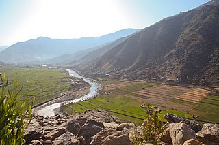
The Alingar River in Laghman Province of Afghanistan is one of the major tributaries of the Kabul River, and part of the Indus River basin. It has two sources, the Ramgel and Kulem rivers.
Alishang is the name of a village, a river and a fertile valley of Laghman Province, and also of the district headquarters of Mihtarlam District, in eastern Afghanistan. It lies about 40 km northwest of Jalalabad.
Laghman University is a state university located in Mihtarlam, Laghman Province, in eastern Afghanistan. It was established in 2011. Laghman University has 72 bachelor's and master's degree teachers in five faculties.
