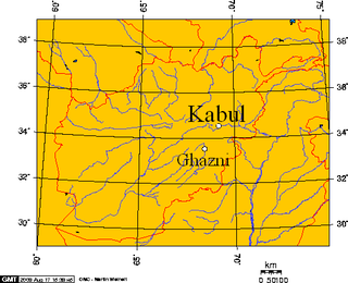
Ghazni, historically known as Ghaznayn (غزنين) or Ghazna (غزنه), also transliterated as Ghuznee, and anciently known as Alexandria in Opiana, is a city in southeastern Afghanistan with a population of around 190,000 people. The city is strategically located along Highway 1, which follows the path that has served as the main road between Kabul and Kandahar for thousands of years. Situated on a plateau at 2,219 metres (7,280 ft) above sea level, the city is 150 kilometres (93 mi) south of Kabul and is the capital of Ghazni Province. The name Ghazni drives from the Persian word "ganj", meaning 'treasure'.

Faryab is one of the thirty-four provinces of Afghanistan, which is located in the north of the country bordering neighboring Turkmenistan. It has a population of about 1,109,223, which is multi-ethnic and mostly a tribal society. The province encompasses 15 districts and over 1,000 villages. The capital of Faryab province is Maymana. It also borders Jowzjan Province, Sar-e Pol Province, Ghor Province and Badghis Province.

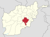
Ghazni is one of the 34 provinces of Afghanistan, located in southeastern Afghanistan. The province contains 19 districts, encompassing over a thousand villages and roughly 1.3 million people, making it the 5th most populous province. The city of Ghazni serves as the capital. It lies on the important Kabul–Kandahar Highway, and has historically functioned as an important trade center. The Ghazni Airport is located next to the city of Ghazni and provides limited domestic flights to Afghanistan's capital, Kabul.

Helmand, also known as Hillmand, in ancient times, as Hermand and Hethumand, is one of the 34 provinces of Afghanistan, in the south of the country. It is the largest province by area, covering 58,584 square kilometres (20,000 sq mi) area. The province contains 18 districts, encompassing over 1,000 villages, and roughly 1,446,230 settled people. Lashkargah serves as the provincial capital. Helmand was part of the Greater Kandahar region until made into a separate province by the Afghan government in the 20th century.

Logar is one of the 34 provinces of Afghanistan, located in the eastern section of the country. It is divided into 7 districts and contains hundreds of villages. Puli Alam is the capital of the province. As of 2021, Logar has a population of approximately 442,037 people, most of whom are ethnic Pashtuns and Tajiks.

Takhar is one of the thirty-four provinces of Afghanistan, located in the northeast of the country next to Tajikistan. It is surrounded by Badakhshan in the east, Panjshir in the south, and Baghlan and Kunduz in the west. The city of Taloqan serves as its capital. The province contains 17 districts, over 1,000 villages, and approximately 1,113,173 people, which is multi-ethnic and mostly a rural society.
Kunar is one of the 34 provinces of Afghanistan, located in the northeastern part of the country. Its capital is Asadabad. Its population is estimated to be 508,224. Kunar's major political groups include Wahhabis or Ahl-e- Hadith, Nazhat-e Hambastagi Milli, Hezb-e Afghanistan Naween, Hezb-e Islami Gulbuddin.

The districts of Afghanistan, known as wuleswali, are secondary-level administrative units, one level below provinces. The Afghan government issued its first district map in 1973. It recognized 325 districts, counting wuleswalis (districts), alaqadaries (sub-districts), and markaz-e-wulaiyat. In the ensuing years, additional districts have been added through splits, and some eliminated through merges. In June 2005, the Afghan government issued a map of 398 districts. It was widely adopted by many information management systems, though usually with the addition of Sharak-e-Hayratan for 399 districts in total. It remains the de facto standard as of late 2018, despite a string of government announcements of the creation of new districts.
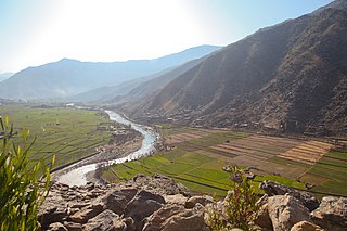
Jaghori is one of the districts of the Ghazni Province in central Afghanistan. Occupying 1,855 km2 (716 sq mi), the district sits in the highlands in the southern fringes of the Hazarajat region, in the upper Arghandab valley.

Ab Band is a district in Ghazni province, Afghanistan. Its population was estimated at 41,340 in 2002. The district is within the heartland of the Tarakai tribe of Ghilji Pashtuns. Ab Band is on the main road from Kabul to Kandahar. The district capital is Ab Band.
Malistan or Malestan, is a district in Ghazni province, Afghanistan. Its population, which is 100% Hazara, was estimated at 350,000 in 2009. The district capital is Mir Adina.

Asadullah Khalid is a politician in Afghanistan. He served as head of the National Directorate of Security (NDS), which is the domestic intelligence agency of Afghanistan. Before his appointment as the head of the NDS in September 2012, Khalid served as the Minister of Tribal and Border Affairs. Between 2005 and 2008, he was the Governor of Kandahar Province and prior to that as Governor of Ghazni Province (2002-2005). From 2018 until 2021 he was the Minister of Defense. Khalid is said to be affiliated with the Islamic Dawah Organisation of Afghanistan and has been noted as one of many loyalists of Afghan President Hamid Karzai.
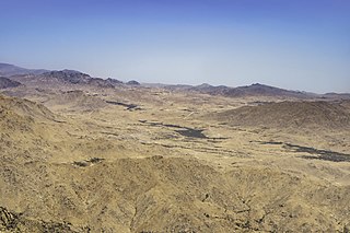
Qarabagh or Qara Bagh is a district in Ghazni province, 56 km to the south-west of Ghazni city in eastern Afghanistan. The 1,800 km2 area is one of the most populated at 109,000; some reports count more than 218,000. The ethnic composition of the district includes Hazaras and Pashtuns. The landscape varies in different parts of the district - deserts in the southwest, plains in the southeast and mountains in the north. The district is seriously affected by drought, especially farming and animal husbandry. Health and education need serious improvement.

The Giro District is located within southeastern Ghazni province in Afghanistan, 50 km South East of Ghazni city. The district is a wide plain with scattered low mountains. More than 40 000 residents are estimated, according to 2002 year's data. The district is within the heartland of the Tarakai tribe of Ghilji Pashtuns. The district center is Pana.

Rashidan District is a new district in Ghazni province, Afghanistan; it was created from the larger Jaghatu district.
Ghazni District, is a district of Ghazni province, Afghanistan situated in the northeast part of the province. Capital of the district is Ghazni, which is also capital of Ghazni Province.
Khugyani is a district in Ghazni province, Afghanistan. It was previously part of Jaghatu District. Its territory had been enlarged during the Taliban regime and after then the district was returned to its original borders. To the east it is surrounded by Ghazni District to the south by Waghaz District, to the west by Jaghatu District, to the north by the Rashidan District and to the Northeast by Khwaja Umari District. The population is more than 28,000 people. The district center is Khogyani.
Events in the year 2018 in Afghanistan.

The Ghazni offensive began on 10 August 2018, when Taliban fighters launched an assault on the city of Ghazni, Afghanistan's sixth largest city and one which has been culturally and strategically important for much of the country's history. The attack resulted in the deaths of hundreds of insurgents, soldiers, police, and civilians. The city also sustained large-scale property damage. The battle, occurring only weeks before Afghanistan's 2018 parliamentary election, was the largest since a three-day truce in June had raised hopes of peace talks.
In May 2020, a series of insurgent attacks took place in Afghanistan, starting with the Taliban killing 20 Afghan soldiers and wounded 29 others in Zari, Balkh and Grishk, Helmand on 1 and 3 May, respectively. On 12 May, a hospital's maternity ward in Kabul and a funeral in Kuz Kunar (Khewa), Nangarhar were attacked, resulting in the death of 56 people and injuries of 148 others, including newborn babies, mothers, nurses, and mourners. ISIL–KP claimed responsibility for the funeral bombing, but no insurgent group claimed responsibility for the maternity ward shooting.