
Sar-e Pol, also spelled Sari Pul, is one of the thirty-four provinces of Afghanistan, located in the north of the country. It borders Ghor and Bamyan to the south, Samangan to the east, Balkh and Jowzjan to the north, and Faryab to the west. The province is divided into 7 districts and contains 896 villages. It has a population of about 632,000, which is multi-ethnic and mostly a tribal society. The province was created in 1988, with the support of northern Afghan politician Sayed Nasim Mihanparast. The city of Sar-e Pol serves as the provincial capital.
Day Mirdad is a district in the south of Wardak Province, Afghanistan. The capital of the district is Miran city. The district used to be known as Jilga.

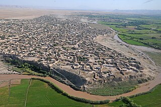
Sarpol-e Zahab County (Persian: شهرستان سرپل ذهاب, Šaharestâne Sarpole Zahâb; Sarpell-i zahaw is in Kermanshah province, Iran. Its capital is the city of Sarpol-e Zahab, whose people are adherents of Shia, Sunni and Yarsan.

Muqur District is a district located within Badghis Province in the western part of Afghanistan. It is located between the districts of Ab Kamari to the east, Qala i Naw to the south, Qadis to the southeast and Bala Murghab to the northeast. To the north is the national border with Turkmenistan. The district is in a long river valley. The estimated population in 2019 was 26,375.

Qala-e-Naw is a town in Qala e Naw District and the capital of Badghis Province, in north-west Afghanistan. Its population was estimated at 9,000 in 2006, of which mostly Sunni Hazaras. Other significant communities include Tajiks, Pashtuns, Balochs and Uzbeks.
Dawlat Abad is a district in Faryab Province, Afghanistan. The population of the district was estimated 95,800 in 2009.
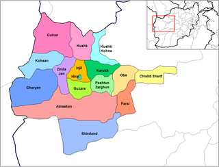
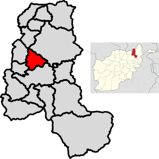
Injil is a district of Herat Province in northwestern Afghanistan. It surrounds Herat City and borders Kushk District to the north, Karukh District to the east, Guzara District to the South, and Zinda Jan District to the west. There is no any official census from this district, therefor all the numbers are based on approximately the population of different localities in the district. The population of Injil District is around 237,800, which includes the following ethnic groups: Around 55% Tajik, around 40% Pashtun. Almost all inhabitants of Jebrael locality are Hazara. Jebrael has a population of around 60-80 thousand people. This makes the population of Hazara in Injil district around 4% and 1% Turkmen.
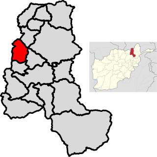
Kohsan is a district of Herat province in northwestern Afghanistan. It borders the nation of Iran to the west, Gulran District to the north, and Ghurian District to the south and east. The population of Kosan District is 52,900, which includes the following ethnic groups: 59.4% Pashtun, 35.3% Tajik, 5.1% Balouch, and 0.2% Turkmen.
Shinḍanḍ District is located in the southern part of Herat Province in Afghanistan, bordering Adraskan District to the north, Ghor Province to the east and Farah Province to the south and west. It is one of the 16 districts of Herat Province. The name Shindand is Pashto and relates to lush green farming area. In Persian language it translates to Sabzwār.

Char Asiab District is a district, approximately 11 km south of the city of Kabul, and is situated in the southern part of Kabul province, Afghanistan. It has a population of 32,500 people. The majority are Pashtuns, followed by Tajiks as well as a few Hazaras.
Khokhi District is located in the East part of Logar Province, Afghanistan. 80 km away from Kabul and 18 km from Pul-i-Alam centre of Logar Province. Centre of the district is called Khoshi and the population is made up of Pashtuns , Tajiks and Hazara, accounting for 65%, 34%, 1% of the total population respectively.

Darqad District is a district of Takhar Province, Afghanistan. The district has 34 villages. Darqad did not change between the 325 and 398 district sets. Near the end of 2018, the district was considered to be Taliban-influenced, as opposed to the Afghan government. The district was Taliban-controlled by August 2021.
Khwaja Ghar District is a district of Takhar Province, Afghanistan. The district was badly destroyed during the 1996-2001 Afghan Civil War in fighting between the Taliban and the Northern Alliance.
Yangi Qala District is a district in Takhar Province, Afghanistan. Economically the population of this district is primarily involved in agriculture. The main crops are rice and wheat, and the surplus rice is exporting to neighboring districts and provinces. There are 64 villages in the district. As of August 2021, the Taliban has full control over this district.

Bādghīs is one of the thirty-four provinces of Afghanistan, located in the northwest of the country, on the border with Turkmenistan. It is considered to be one of the country's most underdeveloped provinces, with the highest poverty rate. The capital is Qala e Naw, while the most populous city and the district are Bala Murghab. The ruins of the medieval city of Marw al-Rudh, the historical capital of the medieval region of Gharjistan, are located in the province near the modern city of Bala Murghab.

Said Karam is a district in Paktia Province, Afghanistan. The main town in the district is Khandkhel. The district is within the heartland of the Muqbil tribe of Pashtuns. Villages in the Said Karam district are Khandkhel (خڼخیل), Khunderkhel, Goud Qala Mangal, Chino Klalai, Shaiyesta Kalay and Shaikhan Kalay (توتاخېل)

Dashti Qala District is a district of Takhar Province, Afghanistan. It split from Khwaja Ghar District in June 2005. This district borders Tajikistan. Ai-Khanoum, probably founded by the Seleucid Empire, is located in this district. In 2018, this district was considered contested between the government and the Taliban.
Hazar Sumuch District is a district of Takhar Province, Afghanistan. The district was split-off from Taluqan District. Most people in the district work in agriculture. In late 2018, Hazar Sumuch was considered to be government influenced as opposed to the Taliban.
Khwaja Bahauddin District is a district of Takhar Province, Afghanistan. The district was created from a portion of Yangi Qala District in 2005. 25 villages are located in Khwaja Bahauddin.
Darvand is a village in Beshiva Pataq Rural District, in the Central District of Sarpol-e Zahab County, Kermanshah Province, Iran. At the 2006 census, its population was 164, in 37 families.

