
Herat is one of the thirty-four provinces of Afghanistan, located in the western part of the country. Together with Badghis, Farah, and Ghor provinces, it makes up the north-western region of Afghanistan. Its primary city and administrative capital is Herat City. The province of Herat is divided into about 17 districts and contains over 2,000 villages. It has a population of about 3,780,000, making it the second most populated province in Afghanistan behind Kabul Province. The population is multi-ethnic but largely Persian-speaking. Herat dates back to the Avestan times and was traditionally known for its wine. The city has a number of historic sites, including the Herat Citadel and the Musalla Complex. During the Middle Ages Herat became one of the important cities of Khorasan, as it was known as the Pearl of Khorasan.

Farah is one of the 34 provinces of Afghanistan, located in the southwestern part of the country next to Iran. It is a spacious and sparsely populated province, divided into eleven districts and contains hundreds of villages. It has a population of about 563,026, which is multi-ethnic and mostly a rural tribal society. The Farah Airport is located near the city of Farah, which serves as the capital of the province. Farah is linked with Iran via the Iranian border town of Mahirud. The province famous tourism sites include Pul Garden, New Garden, Kafee Garden, shrine of Sultan Amir and Kafer castle are from sightseeing places of Farah province
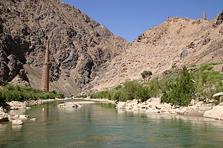
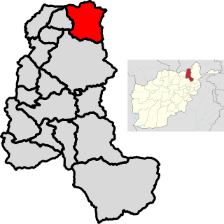
Ghōr, also spelled Ghowr or Ghur, is one of the thirty-four provinces of Afghanistan. It is located in the western Hindu Kush in central Afghanistan, towards the northwest. The province contains eleven districts, encompassing hundreds of villages, and approximately 764,472 settled people. Firuzkoh is the capital of the province.

Parwan also spelled Parvan is one of the 34 provinces of Afghanistan. It is the largest province of the Greater Parwan region and has a population of about 751,000. The province is multi-ethnic and mostly rural society. The province is divided into ten districts. The town of Imam Abu Hanifa serves as the provincial capital. The province is located north of Kabul Province and south of Baghlan Province, west of Panjshir Province and Kapisa Province, and east of Maidan Wardak Province and Bamyan Province. The province's famous tourism attraction is the Golghondi Hill, also known as “the flower hill,” located in Imam Azam about an hour away from the capital city of Kabul. After Panjshir this province has been considered as one of the main raising points of Afghanistan War against Soviets.

Takhar is one of the thirty-four provinces of Afghanistan, located in the northeast of the country next to Tajikistan. It is surrounded by Badakhshan in the east, Panjshir in the south, and Baghlan and Kunduz in the west. The city of Taloqan serves as its capital. The province contains 17 districts, over 1,000 villages, and approximately 1,113,173 people, which is multi-ethnic and mostly a rural society.

Daykundi, also spelled as Daikundi, Daikondi, or Daykondi, is one of the thirty-four provinces of Afghanistan, located in the central part of the country. It has a population of about 516,504 and is a Hazara dominated province.

Chaghcharān, also called Firozkoh, is a town and district in central Afghanistan, which serves as the capital of Ghor Province. It is located on the southern side of the Hari River, at an altitude of 2,230 m above sea level. Chaghcharan is linked by a 380 kilometres (240 mi) long highway with Herat to the west, and a 450 kilometres (280 mi) long highway with Kabul to the east. The town has an airport called Chaghcharan Airport.

Dezful County is in Khuzestan province, Iran. Its capital is the city of Dezful.
Qurghan is a district in Faryab province, Afghanistan. It was created in 2005 from the western part of Andkhoy District. The district center Qurghan is very close to Andkhoy at 317 m altitude.
Khwaja Sabz Posh is the district where the Faryab province capital Maymana is located. It is a rural district without its own capital. The Khwaja Sabz Posh district is the closest district to the north of Maymana city. Khoja Sabz Posh is the name of a deceased village elder who was famous for always wearing the color green. There is a shrine dedicated to him on a hilltop just north of the Bazaar. It contains 85 villages. Ethnic diversity includes 80% Uzbek, 10% Pashtun and 10% Tajik.

Deh Yak is a rural district in the eastern part of Ghazni Province, Afghanistan, 30 km east from the city of Ghazni. The district has an area of 715 km2, containing 66 villages and a population of about 44,386. Ramak serves as the district's headquarters.
Pasaband District is located in Ghor province, Afghanistan. The population is 92,900. Located in the southern part of Ghor province, Pasaband District borders Helmand province to the south, Daykundi province to the east, and Farah province to the southwest. The district center is Shinkot.
Saghar District is situated in the most southwestern part of Ghor province, Afghanistan with district center Titan. The population is 33,700 people. The district, as the other mountainous districts in the province, suffers long and severe winters and continuing drought during the summer.
Taywara (Teyvareh) district is located in the southern part of Ghor province in Afghanistan. The population is 88,900 people. The district center is the town of Taywara.

Chishti Sharif District, also known as Chisht District, is the most easterly district in Herat Province, Afghanistan, situated along the Hari River and one of its northern tributaries. It borders with Obe District to the west, Badghis Province to the north and Ghor Province to the east and south. The population was estimated at 23,100 in 2012. The district administrative center is the village of Chishti Sharif.
Farsi is a district the west of Herat Province, Afghanistan. It borders on Obe District to the north, Adraskan District to the west, Shindand District to the south and Ghor Province to the south and east. The population was estimated at 29,800 in 2012. The district center is the village of Farsi.
Chah Ab District is a district of Takhar Province, Afghanistan. Its district center is Chah Ab. The district's economy is primarily based on agriculture and livestock.

Bādghīs is one of the thirty-four provinces of Afghanistan, located in the northwest of the country, on the border with Turkmenistan. It is considered to be one of the country's most underdeveloped provinces, with the highest poverty rate. The capital is Qala e Naw, while the most populous city and the district are Bala Murghab. The ruins of the medieval city of Marw al-Rudh, the historical capital of the medieval region of Gharjistan, are located in the province near the modern city of Bala Murghab.
Shahrak-e Vali-ye Asr Sar Tang-e Bahram Khani is a village in, and the capital of, Dustan Rural District of the Central District of Badreh County, Ilam province, Iran.
Rizhaw is a city in the Central District of Dalahu County, Kermanshah province, Iran, serving as the administrative center for Ban Zardeh Rural District. Rizhaw is in an agricultural and tourist area due to its picturesque nature.


