
Kāfiristān, or Kāfirstān, is a historical region that covered present-day Nuristan Province in Afghanistan and its surroundings. This historic region lies on, and mainly comprises, the basins of the rivers Alingar, Pech (Kamah), Landai Sin and Kunar, and the intervening mountain ranges. It is bounded by the main range of the Hindu Kush on the north, Pakistan's Chitral District to the east, the Kunar Valley in the south and the Alishang River in the west.

Kapisa is one of the 34 provinces of Afghanistan. Located in the north-east of the country. The population of Kapisa is estimated to be 364,900, although there has never been an official estimate. The province covers an area of 1,842 km2 making it the smallest province in the country, however it is the most densely populated province apart from Kabul Province. It borders Panjshir Province to the north, Laghman Province to the east, Kabul Province to the south and Parwan Province to the west. Mahmud-i-Raqi is the provincial capital, while the most populous city and district of Kapisa is Nijrab.

Muqur District is a district located within Badghis Province in the western part of Afghanistan. It is located between the districts of Ab Kamari to the east, Qala i Naw to the south, Qadis to the southeast and Bala Murghab to the northeast. To the north is the national border with Turkmenistan. The district is in a long river valley. The estimated population in 2019 was 26,375.

Andarab district is located in the southern part of Baghlan Province, Afghanistan. The estimated population of Andarab in 2004 was roughly 120,642. Tajiks make up the entire population of the district. The district centre is the village of Andarab.
Istalif District is located in the northwestern part of Kabul Province, Afghanistan. It has a population of 8,500, a mixture of Tajiks, Pashtuns and Hazaras.

Surobi, Sarobi, or Sarubi District is a district of Kabul Province, Afghanistan. Its capital, Surobi, lies about 60 kilometres east of Kabul along the A01 highway, although much of the district lies northeast of Kabul. Surobi is famous all over Afghanistan as it is birthplace to Faisal Babakarkhail a well known Jihadi commander famous for his bravery and courage against Soviet Troops. Its principal river is the Kabul River.
Alishing District is a district in Afghanistan, located 21 km from Mihtarlam, the provincial centre of Laghman Province. It has borders with Kabul and Kapisa provinces to the West, Dawlat Shah District to the North, Alingar District to the East and Mihtarlam District to the South. The population is 79,257 (2019) - 65% of them Pashai, 20% Pashtun and 15% Tajik. The district center is the village of Alishing (Alishang), located on 34.7044°N 70.1539°E at 862 m altitude. There are 12 zones, each with around 12 to 14 villages located in the valleys and mountains. The Alishing river crosses the district and is the main source of irrigation.
Dawlat Shah District is located approximately 74 km from Mehterlam, the provincial centre of Laghman Province in Afghanistan. It is a mountainous district and borders Nuristan Province to the North and North-East, Alingar District to the East, Alishing District to the South and Kapisa and Parwan provinces to the West. The population is 36,950 (2019) - 50% Tajik, 40% Pashai and 10% Pashtun. It has 60 villages. The district center is the village of Dawlat Shah, located on 34.9528°N 70.07°E at 1583 m altitude in the Hindukush mountains in the valley of the Alishing river.
Surōbī is a town and the center of Surobi District in Kabul Province, Afghanistan, located at the junction of the Kabul River and Panjshir River. Surobi is located on 34.5897°N 69.7625°E at 998 m altitude between Kabul and Jalalabad. The population was more than 22,000 people in 2007.
Nesh is a village and the center of Nesh District, Kandahar Province, Afghanistan. It is located on 32.4275°N 65.6408°E at 1,506 m altitude.

The Alasay District is situated in the eastern part of Kapisa Province, Afghanistan. It borders Tagab District to the south and east, Nejrab District to the north and Laghman Province to the east. The population is 38,642 (2015). The district center is Alasay, located in its southwestern part.
The village of Alasay is the center of Alasay District in Kapisa Province, Afghanistan. It is located on 34.8958°N 69.7208°E at 1672 m altitude.
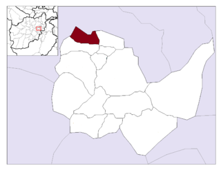
Hesa Duwum Kohistan District is a district in the southern part of Kapisa Province, Afghanistan. The center is the village of Kishiktan. The population is 39,900 (2006) and is mostly composed of Tajik. The district is famous for its sweet mulberries, grapes, apricots and pomegranates. Yearly, hundreds of visitors spend their weekends along the Kohistan river that flows into Surobi lake. During the war against USSR, Kohistani was one of the headquarters for Mujahidin. Kohistan is located at the crossroots with Parwan and Panjshir provinces. Jamal Aagha ist one another village of this District.
Kishiktan (کشکتان) or Kesektan is the center of the newly created Hesa Duwum Kohistan District in Kapisa Province, Afghanistan. It is located on 35.0467°N 69.2919°E at 1454 m altitude.
Mahmud Raqi District is located in the western part of Kapisa Province, Afghanistan. It borders with Parvan Province to the south and with other districts from Kapisa Province: Nejrab District and the former Kohistan District to the north and Tagab District to the southeast. The district center is the town of Mahmud Raqi - the provincial capital. The population is 56,800 (2006).
Nijrāb District,, also called Nijrāw, is situated in the central part of Kapisa Province, Afghanistan. It is located in a valley about 120 km northeast of Kabul. It borders Mahmud Raqi and Koh Band districts to the west, Parwan Province to the north, Laghman Province and Alasay District to the east and Tagab District to the south. The district center is Nijrab, located in the southern part of the district. The population of Nijrab District is 99,600 (2006), making it the most populous district of Kapisa.
Nijrāb is a city with five valleys in Kapisa Province, Afghanistan. It is located at 34.9775°N 69.5742°E at 1,613 m altitude. There are a medical clinic, schools and radio station in the District. Nijrab is the most populous city of Kapisa, while Nijrab District, with a population of 114,726 (2015), is also the most populous district of Kapisa.
The Tagab District is situated in the eastern part of Kapisa Province, Afghanistan. It borders with Parvan Province to the West, Mahmud Raqi and Nijrab in Nijrab is to the North, Alasay District to the East and Kabul Province to the South-East. The population is 71,700 (2006) - Pashtun and some Pashai. The district center is the village of Tagab, located in the western part of the district.
Tagab is a village and the center of Tagab District, Afghanistan. It is located at 34.8556°N 69.6494°E at 1,322 m altitude. The population in the village area was calculated to be 6,628 in the year 2007.
Gulbahar is located 76 km north the Afghanistan capital Kabul. Gulbahar is a green lush area with the best mulberry in the country.
