Related Research Articles
Zabol is a city in the Central District of Zabol County, Sistan and Baluchestan province, Iran, serving as capital of both the county and the district. Zabol is near the border with Afghanistan.

Farah is one of the 34 provinces of Afghanistan, located in the southwestern part of the country next to Iran. It is a spacious and sparsely populated province, divided into eleven districts and contains hundreds of villages. It has a population of about 563,026, which is multi-ethnic and mostly a rural tribal society. The Farah Airport is located near the city of Farah, which serves as the capital of the province. Farah is linked with Iran via the Iranian border town of Mahirud. The province famous tourism sites include Pul Garden, New Garden, Kafee Garden, shrine of Sultan Amir and Kafer castle are from sightseeing places of Farah province
Nimruz or Nimroz is one of the 34 provinces of Afghanistan, located in the southwestern part of the country. It lies to the east of the Sistan and Baluchestan Province of Iran and north of Balochistan, Pakistan, also bordering the Afghan provinces of Farah and Helmand. It has a population of about 186,963 people. The province is divided into five districts, encompassing about 649 villages.

Daykundi, also spelled as Daikundi, Daikondi, or Daykondi, is one of the thirty-four provinces of Afghanistan, located in the central part of the country. It has a population of about 516,504 and is a Hazara dominated province.

Zaranj is a city in southwestern Afghanistan, which has a population of 160,902 people as of 2015. It is the capital of Nimruz Province and is linked by highways with Lashkargah and Kandahar to the east, Farah to the north and the Iranian city of Zabol to the west.
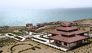
Chābahār ; is a city in the Central District of Chabahar County, Sistan and Baluchestan province, Iran, serving as capital of both the county and the district. It is a free port situated on the coast of the Gulf of Oman, and is Iran's southernmost city. The sister port city of Gwadar in Balochistan, Pakistan, is located about 170 kilometres (110 mi) to the east of Chabahar.
Sayghan District, also spelt Saighan, Seyghan and other variant spellings, and also known as Saraik or Sarayek, and other variant spellings of this name, is an administrative district of Bamyan province, Afghanistan.
Kijran, also spelled as Kajran, is a district in Daykundi province in central Afghanistan. It has an area of about 1,886 square kilometres.
Qurghan is a district in Faryab province, Afghanistan. It was created in 2005 from the western part of Andkhoy District. The district center Qurghan is very close to Andkhoy at 317 m altitude.
Andarab is district located in the southern part of Baghlan Province, Afghanistan. The estimated population of Andarab in 2004 was roughly 120,642. The district centre is the village of Andarab, which is named after the Andarab valley in which it is located.

Shahrak District is located in the western part of Ghor province, Afghanistan. The population is 58,200. The district center is Dahan-e Falezak.

Chahar Burjak District is a district of Nimruz Province in Afghanistan. At just under 22,000 square kilometres (8,500 sq mi) in area, it is the largest district in Afghanistan. The Kamal Khan Dam is located in this district.
Khash Rod District or Khashrowd is a district of Nimruz Province in Afghanistan. It had a population of 35,381 in 2004, which was 55% ethnic Pashtun, 20% Baloch, 15% Brahui and 10% Tajik. The district capital is Ghorghori.

Sancharak District or Sangcharak is a district of Sar-e Pol Province, Afghanistan. Its center is the city of Tukzar or Tokzar. Sancharak district borders Balkh Province in the east. Sancharak District's area is 1089 square kilometres.

Bādghīs is one of the thirty-four provinces of Afghanistan, located in the northwest of the country, on the border with Turkmenistan. It is considered to be one of the country's most underdeveloped provinces, with the highest poverty rate. The capital is Qala e Naw, while the most populous city and the district are Bala Murghab. The ruins of the medieval city of Marw al-Rudh, the historical capital of the medieval region of Gharjistan, are located in the province near the modern city of Bala Murghab.

Abdul Karim Brahui is a former politician in Afghanistan. He last served as Governor of Nimroz Province from 2010 to 2012, and before that he served as a minister in the Cabinet of Afghanistan. From February 2009 to August 2010, Brahui served as Minister of Refugees. In 2004, Brahui was appointed as Minister of Borders and Tribal Affairs.

Delārām is a city in the northern part of Nimruz Province, in southern Afghanistan. It is a major transportation center, with several major road converging on the area, including Kandahar–Herat Highway, Route 515 to Farah, Route 522 to Gulistan and Route 606 to Iran. The district center contains a large bazaar.
Ghorband, also known as Syagird after its main town, is a district of Parwan province, Afghanistan. Ghorband is located in the southern foothills of Hindu Kush and forms the western boundary of the ancient valley of Koh Daman. It is located 50 km from Kabul, the capital of Afghanistan. The capital lies at the town of Siah Gerd. It is the largest district of the province, covering an area of 899 square kilometres with a population of 74,123 as of 2003. The Ghorband River flows through the district. It contains 58 Community Development Councils and 109 villages. Eventually, Ghorband valley was once much bigger then today reaching to the east Shibar, Doshi and Kahmard districts in Bamyan and Baghlan provinces.
Tukzar is a town in Sancharak district of Sar-e Pol Province, Afghanistan. The town is the administrative centre of Sancharak district.

The capture of Zaranj, the capital of Nimruz Province, Afghanistan, occurred on 6 August 2021. According to local officials, only the National Directorate of Security (NDS) and its forces had put up a fight against the Taliban, but they too eventually surrendered to the Taliban. Local officials had been requesting reinforcements but received no response. Zaranj was the first provincial capital to be taken by the Taliban in their 2021 offensive and the first one to be captured since Kunduz in 2016.
References
- ↑ رامین (2016-11-27). "دهاقین، بارش برف در ولایت نیمروز را نوید خوب برای زراعت می دانند" (in Persian). Retrieved 2024-03-07.
- ↑ Islamic Republic of Afghanistan, Ministry of Rural Rehabilitation and Development, National Area Based Development Programme. Summary of District Development Plan - Zaranj District, Nimroz Province [usurped] . April 2007
- ↑ Islamic Republic of Afghanistan, Ministry of Rural Rehabilitation and Development, National Area Based Development Programme. Summary of District Development Plan - Zaranj District, Nimroz Province [usurped] . April 2007
| Districts |  | |
|---|---|---|
| Populated places | ||
| Landforms | ||
| Other | ||
30°57′36″N61°51′36″E / 30.9600°N 61.8600°E
| | This Nimruz Province, Afghanistan location article is a stub. You can help Wikipedia by expanding it. |