
Nuristan, also spelled as Nurestan or Nooristan, is one of the 34 provinces of Afghanistan, located in the eastern part of the country. It is divided into seven districts and is Afghanistan's least populous province, with a population of around 167,000. Parun serves as the provincial capital. Nuristan is bordered on the south by Laghman and Kunar provinces, on the north by Badakhshan province, on the west by Panjshir province.

Mardan District is a district in the Mardan Division of the Khyber Pakhtunkhwa province of Pakistan. The district is named after Mardan city, which is also the headquarters of the district. The district is famous for its agriculture industry and its archaeological sites, specifically of Takht-i-Bhai, Jamal Garhi and Sawal Dher.
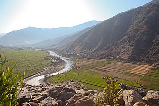
Kunar is one of the 34 provinces of Afghanistan, located in the northeastern part of the country. Its capital is Asadabad. Its population is estimated to be 508,224. Kunar's major political groups include Wahhabis or Ahl-e- Hadith, Nazhat-e Hambastagi Milli, Hezb-e Afghanistan Naween, Hezb-e Islami Gulbuddin.

Upper Dir District is a district located in the Malakand Division of Khyber Pakhtunkhwa province of Pakistan. The city of Dir is its district headquarter. Geographically, it is located in the northern part of Pakistan. It borders with the Chitral district on the north, Afghanistan on the northwest, the Swat district on the east, and the Lower Dir district on the south. It shares 40 to 50 kilometers border with Afghanistan.

Bajaur District is a district in the Malakand Division of Khyber Pakhtunkhwa province of Pakistan. Until 2018, it was an agency of the Federally Administered Tribal Areas. in 2018, it was merged with Khyber Pakhtunkhwa, after the announcement of annexing FATA with KPK. According to the 2017 census report, the population of the district was 1,093,684. It shares a 52 km border with Afghanistan's Kunar Province. The town of Khar is its district headquarter.

Goshta District is located in the northeast of Nangarhar Province, Afghanistan and borders Durand Line between Afghanistan and Pakistan. The district's population is Pashtun and was estimated at 160,000 in 2002, of whom 30,000 were children under 12. The district is within the heartland of the Mohmand tribe of Pashtuns. The district centre is the village of Goshta, on the Kabul River.

Asadabad district is one of 15 districts in the Kunar Province of Afghanistan. It includes the city of Asadabad - the district center, close the Kunar River. It is situated in the central part of the province. It has 12 big and small villages, which are surrounded by mountains so there is not enough land for farming.

Alishing District is a district in Afghanistan, located 21 km from Mihtarlam, the provincial centre of Laghman Province. It has borders with Kabul and Kapisa provinces to the West, Dawlat Shah District to the North, Alingar District to the East and Mihtarlam District to the South. The district center is the village of Alishang, located on 34.7044°N 70.1539°E at 862 m altitude. There are 12 zones, each with around 12 to 14 villages located in the valleys and mountains. The Alishing river crosses the district and is the main source of irrigation.

Marawara District is one of the 15 districts in Kunar Province, Afghanistan. It borders Sirkanay District to the west, Asadabad District to the north-west, Dangam District to the north-east and the Durand Line to the south. Marawara's population is not exactly known but government figures estimate it to be around 22,270 people, all of them being ethnic Pashtuns. Marawara village is the center of the district and is located in its westernmost part.

A series of occasional armed skirmishes and firefights have occurred along the Afghanistan–Pakistan border between the Afghan Armed Forces and the Pakistan Armed Forces since 1949. The latest round of hostilities between the two countries began in April 2007. Militants belonging to Tehrik-i-Taliban Pakistan and Jamaat-ul-Ahrar also use Afghanistan's territory to target Pakistani security personnel deployed along the border. The Diplomat says that the presence of terrorists belonging to Tehrik-i-Taliban Pakistan on Afghan soil is the reason for sporadic shelling of Afghanistan's territory by Pakistani security forces.

Spera District is situated in the most southwestern part of Khost Province, Afghanistan. It borders with Paktia Province to the south and west, Shamal District to the north. The district is within the heartland of the Zadran tribe of Pashtuns. To the east it borders Nadir Shah Kot and Tani districts as well as Khyber Pakhtunkhwa in Pakistan. The population of Spera District is around 21,500 people. The district center is the village of Spera, situated in the central part of the district.
Bar Kunar District is situated in the northeastern part of Kunar Province, Afghanistan. It borders Asadabad district to the southwest, Nuristan Province to the northwest, Nari district to the northeast and Dangam district to the southeast. The population is 19,500 (2006) - all Pashtun. The district center is the village of Asmãr at 983 m elevation in a river valley, located in the most southern part of the district.
The district is mountainous and the arable land is not enough and people are poor. It is said that the fight against the Soviet Army started in this district.
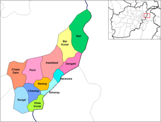
Dangam District is situated in the eastern end of Kunar Province in Afghanistan. It borders Marawara district to the southwest, Asadabad district to the west, Bar Kunar district to the north, Nari district to the northeast and Khyber Pakhtunkhwa in Pakistan to the east. The district is mountainous and stunning but also poor.
Ghaziabad District is in the northern part of Kunar Province, Afghanistan. It was created in 2004 from the northern part of Bar Kunar District. It was named after the Khan of Ghaziabad, Amir Muhammad Ghazi Khan Shaheed. Its population is 7,500 (2004).
Shegal District was split from Chapa Dara District in Kunar Province, Afghanistan and the population is 13,351 (2019). Waheedullah Sabawoon and late Kashmir Khan, two of the famous politicians of Afghanistan, belonging to this district. Wall nut, Malt, date plum and plum are the famous fruits while, rice, wheat, sugarcane, corns and cotton are the main crops cultivated in the district. The Kunar river is separating Shugal from Shultan while both areas are connected by Shultan bridge. Since last couple of years, the Shultan separated and has become a district. It has a long border with neighbor Pakistan. Villages in Shegal district include Dag-e-Ser, Shangurgul, Lachay, Monay, Helalzo, Naret, Chaqore, and more. In Shegal District 80% of males and 30% of females are educated.
Watapur District is situated in the central part of Kunar Province in Afghanistan. It was split from Asadabad district. The district is mountainous with 60 large and small villages. The population is around 60,000. Degan, Safi, Ragakhel, Sharbekhel, Nanekhel, Doshakhel, Kohestani, Saidan are the few tribes living in this beautiful place. Watapur District has a high school located in south part of the district. The villages are located in the valleys or in the high mountains, with difficult or no road access to the center - Asadabad, and it takes one day to reach some of them. There was a medical clinic north of Qatar Kala, built by ISAF, until it was destroyed by local militants.

Narang, Kunar, Afghanistan نرنګ in Pashto and Persian is situated in the central part of Kunar Province, Afghanistan south of Asadabad. It is surrounded by high mountains and the Kunar River. The population is 36,700 (2014). The district center is the village of Kuz Narang at 742 m altitude. It is the kunar 2nd largest district regarding Agriculture Land. The irrigation system is under rehabilitation. The land is in much good condition and fertile. The irrigation system is almost the best in Kunar province. About 75% of the people are educated. The famous villages are: 1: Bar-Narhang 2: Kotkay 3: Badel dara 4: kuz-Narhang 5: Lamatak 6: dandona 7: Char qala 8: kodo ; etc.

Khas Kunar or Sarkani(sarkano) District is the largest district in the Kunar Province, Afghanistan. It is situated in the southern part of the province and borders Nangarhar Province to the south and Pakistan to the east. The Kunar River passes north through the district and irrigates the surrounding land. The population was estimated to be 31,000 in 2006. The district center, Khas Kunar village is located at 34.6458°N 70.9008°E at 749 m altitude. Most of the houses were destroyed during the wars and droughts also have seriously affected the lands all around the Kunar River. The most influential person from this district was Kabir Stori, who was a Pashtun nationalist.
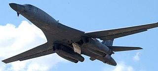
The Gora Prai airstrike was an airstrike by the United States that resulted in the deaths of 11 paramilitary troops of the Pakistan Army Frontier Corps and 8 Taliban fighters in Pakistan's tribal areas. The attack took place late on June 10, 2008, during clashes between US coalition forces and militants from the Pakistani Taliban.

The Kalasha, or Kalash, are an Indo-Aryan indigenous people residing in the Chitral District of the Khyber-Pakhtunkhwa province of Pakistan.

