Jalalabad

Last updated

Jalalabad
جلال‌آباد
Aerial view of Jalalabad in 2012.jpg
Irrigation in the fields of Jalalagad, Afghanistan (5774070247).jpg
Ghousejaa.jpg
Jalalabad stadium in 2011.jpg
Bridge in Jalalabad in 2011.jpg
Jalalabad in January 2011.jpg
From top counter-clockwise: An aerial view of a section of Jalalabad, Irrigation fields in Jalalabad, Jalalabad Cricket Stadium, Jalalabad in January 2011, Jalalabad Bridge, Governor's House in Jalalabad
Afghanistan adm location map.svg
Red pog.svg
Jalalabad
Location in Afghanistan
Hindu-Kush.jpg
Red pog.svg
Jalalabad
Jalalabad (Hindu-Kush)
Coordinates: 34°26′03″N70°26′52″E / 34.43417°N 70.44778°E / 34.43417; 70.44778
Country Flag of the Taliban.svg Afghanistan
Province Nangarhar
District Jalalabad
Founded1570
Government
[1]
  Type Municipality
   Mayor Qari Bismellah Bilal
  Deputy MayorMohammad Ishaq Saeed
Area
[2]
  Land122 km2 (47 sq mi)
Elevation
575 m (1,886 ft)
Population
 (2025) [3]
318,733
  Density2,610/km2 (6,770/sq mi)
   Urban
318,733
Time zone UTC+04:30 (Afghanistan Time)
ISO 3166 code AF-JAA
Climate BWh
Website jalalabad-m.gov.af

Jalalabad, [a] [b] previously known as Tarunshahr, [4] and historically known as Nagarahara or Adinapur, [5] is a city in eastern Afghanistan, serving as the capital of Nangarhar Province. It has an estimated population of 318,733 people. [3] Qari Bismellah Bilal is the current mayor of the city. [1] Mohammad Ishaq Saeed serves as the current deputy mayor. [6]

Contents

Jalalabad is home to Nangarhar University, which is in the northwestern area of the city. The Jalalabad Airport is in the southeastern part of the city. Jalalabad has a number of industrial parks, bazaars, business centers, public parks, banks, hotels, restaurants, mosques, hospitals, universities, and places to play sports or just relax. The city is connected by a road network with Asadabad to the northeast, Torkham to the southeast, and Kabul to the west. It is about 80 mi (130 km) from the city of Kabul.

Jalalabad is located at the junction of the Kabul River and the Kunar River in a plateau to the south of the Hindu Kush mountains. [7] It is a leading center of social and trade activity because of its proximity with the Torkham border checkpoint and border crossing, 65 km (40 mi) away. [8] Major industries include poultry farming, processing agricultural products such as dried fruits, olives, dates, oranges and sugarcane, and producing household products and various types of snacks. For centuries the city was favored by Afghan kings [9] and it has a cultural significance in Afghan poetry. [7] During Timur Shah's reign of the Durrani Empire, Jalalabad served as the Afghan winter capital. [10]

History

Ancient and medieval

Known at the time by names such as Nagarahara and Adinapur, Jalalabad was a major center of Greco-Buddhist culture during the late 1st millennium BCE, focused on sites such as Ahin Posh.

The first surviving references to the city are in early 1st millennium CE accounts by visiting Chinese Buddhist monks. In or about 400 CE, Faxian visited "Nagarahara" and worshiped at sacred Buddhist sites, such as the "Cave of the Buddha's Shadow” (佛影窟). [11] In 630 CE, Xuan Zang, visited "Adinapur" and other locations nearby.

The Buddhist era began to end after the region was conquered by Muslim forces during the late 1st millennium. However, complete conversions to Islam evidently did not occur quickly. In Hudud-al-Alam , written in 982 CE, there is reference to a village near Jalalabad where a local ruler had Muslim, Buddhist and Hindu wives. [12]

The region became part of the Muslim Ghaznavid Empire in the 10th century. Sabuktigin annexed the land all the way west of the Neelum River in Kashmir. "The Afghans and Khiljies who resided among the mountains having taken the oath of allegiance to Sabuktigin, many of them were enlisted in his army, after which he returned in triumph to Ghazni." [13] The Ghurids succeeded the Ghaznavids and expanded the Islamic culture further into Hindustan. The region around Jalalabad later became part of the Khalji territory, followed by that of the Timurids. [14]

Modern

The Bagh-e Shahi palace and gardens, c. 1920. Royal Park Jalalabad postcard.jpg
The Bagh-e Shahi palace and gardens, c. 1920.
The Emir's gardens, pictured in the 19th century. The Amir's Garden, Jalalabad WDL11478.png
The Emir's gardens, pictured in the 19th century.

It is said that the original name of Jalalabad was Adinapur or Nagar(a)hara. [5] Jalalabad was named in the last decade of the sixteenth century in honor of Jalal-uddin Mohammad Akbar, ruler of the Mughal Empire at the time. His grandfather Babur had chosen the site for this city which was built by his grandson. [15]

It remained part of the Mughal Empire until around 1738 when Nader Shah and his Afsharid forces defeated the Mughals. Nader Shah's forces were accompanied by the young Ahmad Shah Durrani and his 4,000-strong Afghan army from southern Afghanistan. In 1747, he founded the Durrani Empire (Afghan Empire) after re-conquering the area. The Afghan army has long used the city while going back and forth during their military campaigns into Hindustan.

In 1834, Dost Mohammad Khan subjugated Jalalabad in his campaign to Jalalabad. [16] The British-Indian forces invaded Jalalabad in 1838, during the First Anglo-Afghan War. In the 1842 Battle of Jellalabad, Akbar Khan besieged the British troops on their way to Jalalabad. In 1878, during the Second Anglo-Afghan War, the British again invaded and set up camps in Jalalabad but withdrew two years later.

Jalalabad was besieged by rebel tribes in November 1928, marking the start of the Afghan Civil War of 1928-1929. [17] [18]

Jalalabad is considered one of the most important cities of the Pashtun culture. Seraj-ul-Emarat, the residence of Amir Habibullah and King Amanullah was destroyed in 1929 when Habibullah Kalakani rose to power; the other sanctuaries however, retain vestiges of the past. The mausoleum of both rulers is enclosed by a garden facing Seraj-ul-Emart. The Sulaimankhels, a Pashtun family famous for their scientific research, is from Jalalabad. Other celebrated Pashtun families originate from the villages near Jalalabad too.
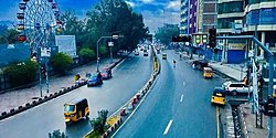
Aerial view of Jalalabad Aerial view of Jalalabad in 2012.jpg
Aerial view of Jalalabad
One of the main roads where movements of auto rickshaws have been banned nnKrhr.jpg
One of the main roads where movements of auto rickshaws have been banned

By the early 1970s, construction had started on a new planned community within Jalalabad called Reg-e Shamshad Khan. [19] From 1978 to early 1990s, the city served as a strategic location for the Soviet-backed Democratic Republic of Afghanistan and was temporarily renamed to Tarunshahr, in honour of Daoud Tarun. [4] In March 1989, two mujahideen rebel factions backed by Pakistan and the United States assaulted the city during the Battle of Jalalabad. However, government forces managed to drive them out within two months, which was a major setback to the rebel fighters and Pakistan's ISI. [20] The city was heavily bombarded and hundreds of civilians were killed. Many buildings, such as schools, hospitals and public buildings were destroyed during the 2-month battle. [21]

On April 19, 1992, after then-President Najibullah resigned, Jalalabad fell to mujahideen rebel forces under Yunus Khalis. [22] On September 12, 1996, the Taliban took control of the city until they were toppled by the US-backed Afghan forces in late 2001, which resulted in the Afghan Interim Administration under Hamid Karzai taking control. According to the United States, al-Qaeda had been building military training camps in the area.

In March 2007, US marines murdered 19 unarmed civilians and wounded 50 near Jalalabad, in an incident compared by the New York Times to the Haditha massacre. None of those responsible received any serious punishment. [23] The Jalalabad Airport has long served as a military base for the NATO forces. Many suicide attacks by jihadist insurgents have taken place, including in August 2013, April 2015, January 2018, July 2018, September 2018, October 2019 and August 2020. The groups responsible for the attacks include the Taliban, Haqqani Network, al-Qaeda, and ISIS (Daesh). On August 15, 2021, the Taliban took control of Kabul and Jalalabad. [24] [25]

Geography

Jalalabad is a strategic city in eastern Afghanistan. It connects by a road network with Asadabad to the northeast, Torkham to the southeast, and Kabul to the west. It is at an elevation of 575 m (1,886 ft) above sea level, next to where the Kunar River merges into the Kabul River. The city is administratively divided into 6 city districts ( nahias ), covering a land area of 122 km2 (47 sq mi) or 12,796 ha (31,620 acres). [2] [26]

View of the Spin Ghar range from the city of Jalalabad Jalalabad - Spin Ghar Range.JPG
View of the Spin Ghar range from the city of Jalalabad
View towards the city from the Kabul River banks to the north Jalalabad, Afghanistan (5397994701).jpg
View towards the city from the Kabul River banks to the north

Agriculture is the predominant land use at 44%, higher density of dwellings is found in Districts 1–5 and vacant plots are largely clustered in District 6. Districts 1–6 all have a grid network of roads. [26]

Flora and fauna

Jalalabad is home to a large number of fruit. Various types of citrus fruits like orange, tangerine, grapefruit, lemon, lime grow in gardens as well as in orchards. [27] [28] The narindj variety of orange is the most common one which has yellow skin and its taste is a combination of orange and grapefruit. The grapefruits grown here have a diameter of eight or nine inches. Per year 1800 tonnes of pomegranates, 334 tonnes of grapes, and 7750 tonnes of mulberries are produced in Jalalabad. [29] The fruits are sold in local markets and transported to Kabul markets from where they are exported. The second most common crop is local vatani variety of sugarcane. It contains 15% sugar by weight. [30] Jalalabad also has one of the largest date farms in Afghanistan. [31]

Climate

Jalalabad's climate is hot desert (Köppen: BWh), and it is one of the hottest localities in Afghanistan. [32] The city's climate has close resemblance to that of Arizona in the United States. [33] It receives six to eight inches (152 to 203 mm) of rainfall per annum which are limited to winter and the months of spring. Frosts are not common, and during the summer, the temperature can reach a maximum of 120 °F (49 °C). [27]

The north and southwestern parts of the city which has lower elevation are welcoming places to winds from the north and west cooling the parts in summer months. Jalalabad has the highest relative humidity in summer compared to other Afghan cities. However, the moderate temperatures of winter has led to various people down the history establishing their settlements in the city. [27] Because of its warm temperature relative to most of Afghanistan, Jalalabad (alongside Peshawar) was often the "winter capital" of various Afghan rulers of the past centuries, [10] [34] while rich people would relocate to villas in Jalalabad to avoid the freezing temperatures in Kabul.

Climate data for Jalalabad
MonthJanFebMarAprMayJunJulAugSepOctNovDecYear
Record high °C (°F)25.0
(77.0)
28.8
(83.8)
34.5
(94.1)
40.5
(104.9)
45.4
(113.7)
47.5
(117.5)
44.7
(112.5)
42.4
(108.3)
41.2
(106.2)
38.2
(100.8)
32.4
(90.3)
25.4
(77.7)
47.5
(117.5)
Mean daily maximum °C (°F)15.9
(60.6)
17.9
(64.2)
22.5
(72.5)
28.3
(82.9)
34.7
(94.5)
40.4
(104.7)
39.3
(102.7)
38.0
(100.4)
35.2
(95.4)
30.5
(86.9)
23.3
(73.9)
17.5
(63.5)
28.6
(83.5)
Daily mean °C (°F)8.5
(47.3)
10.9
(51.6)
16.3
(61.3)
21.9
(71.4)
27.7
(81.9)
32.7
(90.9)
32.8
(91.0)
31.9
(89.4)
28.1
(82.6)
22.2
(72.0)
14.9
(58.8)
9.5
(49.1)
21.5
(70.6)
Mean daily minimum °C (°F)2.9
(37.2)
5.6
(42.1)
10.5
(50.9)
15.3
(59.5)
19.8
(67.6)
24.7
(76.5)
26.7
(80.1)
26.2
(79.2)
21.4
(70.5)
14.4
(57.9)
6.9
(44.4)
3.5
(38.3)
14.8
(58.7)
Record low °C (°F)−14.1
(6.6)
−9.5
(14.9)
−1.0
(30.2)
6.1
(43.0)
10.6
(51.1)
13.5
(56.3)
19.0
(66.2)
17.5
(63.5)
11.0
(51.8)
2.7
(36.9)
−4.5
(23.9)
−5.5
(22.1)
−14.1
(6.6)
Average precipitation mm (inches)18.1
(0.71)
24.3
(0.96)
39.2
(1.54)
36.4
(1.43)
16.0
(0.63)
1.4
(0.06)
6.9
(0.27)
7.7
(0.30)
8.3
(0.33)
3.2
(0.13)
8.3
(0.33)
12.1
(0.48)
181.9
(7.17)
Average rainy days45884111112339
Average relative humidity (%)61606259474052585655586356
Mean monthly sunshine hours 180.9182.7207.1227.8304.8339.6325.9299.7293.6277.6231.0185.63,056.3
Source: NOAA (1964–1983) [35]

Demographics

Jalalabad has an estimated population of 318,733 people. [3] In 2015 there were 39,586 dwelling units in the city. [26]

Nearly all residents of Jalalabad are Muslim, followers of Sunni Islam. The city also has some Sikhs and Hindus, although the community has dwindled since the 1980s. [36] [37] [38] [39] [40]

Economy

Jalalabad has a number of industrial parks. There are at least two steel mills in the city. Major industries in the city include poultry farming, [41] processing agricultural products such as nuts and dried fruits, olive products, dates, oranges, sugarcane, [42] [31] [28] [43] and producing household products and various types of snacks.

Transportation

Auto rickshaws in Jalalabad Jalalabad street with rickshaws.jpg
Auto rickshaws in Jalalabad

Jalalabad is connected by a road network with Asadabad to the northeast, Torkham to the southeast, and Kabul to west. The Kabul–Jalalabad Road is heavily used day and night, and still remains dangerous due to many accidents and the occasional rock falling from the high mountains. In January 2026 the city banned all auto rickshaw movements on the main roads in the city's center. [44] [45]

The Jalalabad Airport (also known as Nangarhar Airport) is located roughly 3 mi (4.8 km) southeast from the city's center. It is a domestic airport for civilian use. [46] It serves the population of the provinces of Nangarhar, Kunar and Nuristan.

There is a proposal for the establishment of a railway from Mazar-i-Sharif in Balkh Province to Jalalabad and then to Torkham in Momand Dara District. [47] [48]

Education

There are a number of public and private schools in Jalalabad. The following is a list of some of the universities in the city.

Sports

Nangarhar Football Stadium (during construction in 2011) Jalalabad stadium in June 2011.jpg
Nangarhar Football Stadium (during construction in 2011)

Cricket, football, futsal and volleyball are the most popular sports in Afghanistan. Jalalabad is represented in domestic cricket competitions by the Nangarhar province cricket team. National team member Hamid Hasan was born in the province and he currently represents Afghanistan in international cricket. The Ghazi Amanullah International Cricket Stadium is the first international standard cricket stadium in Afghanistan. It is located in the Ghazi Amanullah Town, a modern suburb on the southeastern fringe of Jalalabad in Nangarhar Province. Construction on the stadium began in March 2010 when the foundation stone was laid by Omar Zakhilwal, the then-Minister of Finance and President of the Afghanistan Cricket Board. The project, which was developed on 30 acres of land donated by the developer constructing the Ghazi Amanullah Town, cost up the first phase of construction $1.8 million. The first phase, which took one year to complete, included the completion of the stadium itself. The remainder of the phases will see the construction of a pavilion, accommodation for players and administrative buildings. The stadium, which has a capacity of 14,000, was completed before the national team and under-19 team left for Canada and the Under-19 Cricket World Cup Qualifier in Ireland respectively. The two sides inaugurated the stadium in a Twenty20 match. It is hoped that the stadium will be able to attract international teams to play Afghanistan, who currently have One Day International status until at least 2013.

Professional sports teams from Jalalabad
ClubLeagueSportVenueEstablished
Nangarhar Leopards Afghanistan Premier League Cricket Sharjah Cricket Stadium 2018
Speenghar Tigers Shpageeza Cricket League Cricket Ghazi Amanullah International Cricket Stadium 2013
De Spin Ghar Bazan F.C. Afghan Premier League Football Nangarhar Football Stadium2012
Stadiums

Places of interest

The Ghazi Amanullah International Cricket Stadium is next to the Ghazi Amanullah Khan Town, which is about 15 mi (24 km) of driving distance southeast of Jalalabad. Some people of Jalalabad go there for sports purposes while others for leisure and enjoyment purposes. This is especially during holidays or when they receive visitors.

Mausoleum of King Amanullah Khan inside the Siraj-ul-Emarat Park Mausoleum of Amanullah Khan-cropped.jpg
Mausoleum of King Amanullah Khan inside the Siraj-ul-Emarat Park
A shopping area next to Siraj-ul-Emarat Park jl bd Jalalabad city- sherendel Medical Plaza.jpg
A shopping area next to Siraj-ul-Emarat Park

The following are some of the places of interest.

International sister cities

Notable people

See also

Notes

  1. /əˈlæləˌbæd/

References

  1. 1 2 "Massage from Jalalabad Municipality Mayor". Municipality of Jalalabad. Retrieved 18 January 2026.
  2. 1 2 "State of Afghan Cities report 2015 (Volume-I English)". UN-Habitat. pp. 8, 130. Retrieved 22 October 2015.
  3. 1 2 3 "Estimated Population of Afghanistan 2025-26" (PDF). National Statistics and Information Authority. September 2025. p. 29. Retrieved 27 December 2025.
  4. 1 2 (u) Current State of the Afghan Insurgency (Report). Department of State. 6 November 1979.
  5. 1 2 Gazetteer of the Peshawar District 1897–98 Page 55
  6. "Balkh, Nangarhar Municipalities Sign Cooperation Agreement". TOLOnews. 3 March 2025. Retrieved 18 January 2026.
  7. 1 2 "Afghan poets dream of peace in Pashtun Jalalabad | Arts & Ent, Culture | THE DAILY STAR". The Daily Star. Archived from the original on 22 January 2021. Retrieved 3 December 2020.
  8. "Jalālābād". Britannica.com. Retrieved 15 August 2011.
  9. Burns, John F. (11 May 1989). "Inside Jalalabad: A Sad, Crumbling Shel". The New York Times. ISSN   0362-4331 . Retrieved 3 December 2020.
  10. 1 2 Wright, Colin. "Jellalabad, the bastion where General Elphinstone and others were buried during the seige [sic] 1841–42". www.bl.uk. Archived from the original on 11 October 2009. Retrieved 3 December 2020.
  11. Kuwayama, Shoshin (2012). "The Hephthalites in Tokharistan and Northwest India". In Liu, Xinru (ed.). India and Central Asia. Permanent Black. p. 240. ISBN   978-8178243474.
  12. Vogelsang, Willem (2002). The Afghans. Wiley-Blackwell. p. 18. ISBN   978-0-631-19841-3.
  13. "AMEER NASIR-OOD-DEEN SUBOOKTUGEEN". Ferishta, History of the Rise of Mohammedan Power in India, Volume 1: Section 15. Packard Humanities Institute. Archived from the original on 14 May 2013. Retrieved 31 December 2012.
  14. Hewitt, Cooper. "Afghanistan | Countries | Collection of Cooper Hewitt, Smithsonian Design Museum". collection.cooperhewitt.org. Archived from the original on 20 April 2021. Retrieved 26 January 2021.
  15. Adamec, Ludwig W. (2011). Historical Dictionaries of Asia, Oceania, and the Middle East : Historical Dictionary of Afghanistan. Scarecrow Press. p. 264. ISBN   9780810878150.
  16. Noelle, Christine (1997). State and Tribe in Nineteenth Century Afghanistan The Reign of Amir Dost Muhammad Khan (1826-1863). Psychology Press. p. 15. ISBN   9781138982871.
  17. Ali, Mohammed (1933). Progressive Afghanistan. Punjab Educational Electric Press. pp.  15-20.
  18. "Appendix. The Rebellion in Afghanistan. 1928-1929". Summary of Events--Afghanistan. August 1919 to June 1932 (PDF). General Staff, India. 1932.PD-icon.svg This article incorporates text from this source, which is in the public domain .
  19. "Afghanistan, through a lifetime with Hashmat Ghani: Part 2". 6 July 2020. Archived from the original on 2 September 2021. Retrieved 2 September 2021.
  20. Rupert, James (8 July 1989). "AFGHANISTAN REBELS LOSE KEY BATTLE". The Washington Post. Archived from the original on 8 October 2023. Retrieved 28 January 2018.
  21. "3Afghan". Archived from the original on 17 August 2021. Retrieved 4 June 2020.
  22. "Afghan rebels capture Jalalabad". UPI.com. Archived from the original on 28 January 2018. Retrieved 28 January 2018.
  23. Fintan O'Toole, 'Our Hypocrisy on War Crimes,' Archived 2022-08-21 at the Wayback Machine New York Review of Books 26 May 2022 pp. 10–13, p. 12.
  24. "Nangarhar capital Jalalabad also collapses". Pajhwok Afghan News. 15 August 2021. Retrieved 15 August 2021.
  25. "Taliban capture Afghanistan's Jalalabad, cut off Kabul from east". Al Jazeera. 15 August 2021. Archived from the original on 16 August 2021. Retrieved 15 August 2021.
  26. 1 2 3 "State of Afghan Cities report 2015 (Volume-II)". UN-Habitat. p. 46. Retrieved 21 October 2015.
  27. 1 2 3 Michel, p. 30
  28. 1 2 "Sweet orange yield to exceed 2200MT this year: MoAIL". Pajhwok Afghan News. 1 December 2025. Retrieved 18 January 2026.
  29. Michel, p.32
  30. Michel, p.33
  31. 1 2 "Nangarhar Orchard Expects Over 20 Tons of Dates as Local Production Rises". TOLOnews. 5 August 2025. Retrieved 18 January 2026.
  32. "Afghanistan – Drainage". Britannica.com. Archived from the original on 11 November 2021. Retrieved 3 December 2020.
  33. Michel, p. 29
  34. Latifi, Ali M. "Afghanistan halts independence festivities after wedding massacre". www.aljazeera.com. Archived from the original on 11 May 2023. Retrieved 3 December 2020.
  35. "Jalal Abad Climate Normals 1964–1983". National Oceanic and Atmospheric Administration. Archived from the original on 8 May 2024. Retrieved 25 December 2012.
  36. "Afghan Hindus happy with security, seek lands' restitution". Pajhwok Afghan News. 24 August 2025. Retrieved 18 January 2026.
  37. "India welcomes IEA's move to restore Hindus and Sikhs' properties as 'positive development'". Ariana News. 12 April 2024. Retrieved 18 January 2026.
  38. Najibullah, Farangis. "'When Are You Going Back?' Afghanistan's Sikhs, Strangers In Their Own Land". RadioFreeEurope/RadioLiberty. Archived from the original on 2 December 2020. Retrieved 3 December 2020.
  39. Kumar, Ruchi. "The decline of Afghanistan's Hindu and Sikh communities". www.aljazeera.com. Archived from the original on 4 March 2021. Retrieved 3 December 2020.
  40. Bearak, Barry (23 May 2001). "Taliban Propose an Identity Label for the 'Protection' of Hindus (Published 2001)". The New York Times. ISSN   0362-4331. Archived from the original on 22 November 2020. Retrieved 3 December 2020.
  41. در این فارم در یک روز بیشتر از مصرف افغانستان تخم مرغ تولید می شود on YouTube
  42. "Nangarhar Sees 45% Surge in Olive Harvest and Oil Production". TOLOnews. 30 October 2025. Retrieved 18 January 2026.
  43. "Nangarhar produces 516 tons of peanuts in this solar year". Ariana News. 9 January 2023. Retrieved 18 January 2026.
  44. "Rickshaws movement banned on key roads in Jalalabad City". Pajhwok Afghan News. 13 January 2026. Retrieved 18 January 2026.
  45. "Rickshaw Movement Restricted in Jalalabad". TOLOnews. 15 January 2026. Retrieved 18 January 2026.
  46. "Civilian Flights Resume at Nangarhar Airport". TOLOnews. 18 June 2022. Retrieved 26 August 2022.
  47. "Uzbekistan: Afghan-Trans Rail Feasibility Study Underway". TOLOnews. 15 January 2026. Retrieved 18 January 2026.
  48. "Uzbekistan reaches key milestone in the Afghan–Trans Railway project". TOLOnews. 14 January 2026. Retrieved 18 January 2026.
  49. "San Diego Jalalabad Sister Cities". San Diego Jalalabad Sister Cities. Archived from the original on 22 January 2018. Retrieved 28 January 2018.

Further reading

Published in the 19th century

Published in the 20th century