See also
| Districts |  | |
|---|---|---|
| Populated places | ||
| Buildings and structures |
| |
| Other | ||
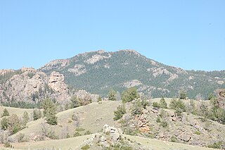
Laghar Juy is a small village in Afghanistan. It is located in the southern portion of the Kot Valley which is at the base of the Spin Ghar mountain range, sometimes referred to as the Tora Bora mountain range. [1]
| Districts | | |
|---|---|---|
| Populated places | ||
| Buildings and structures |
| |
| Other | ||

The geography of France consists of a terrain that is mostly flat plains or gently rolling hills in the north and west and mountainous in the south and the east. Metropolitan France has a total size of 551,695 km2 (213,011 sq mi). It is the third largest country in Europe by area and the largest in Western Europe.
The Laramie Mountains are a range of moderately high peaks on the eastern edge of the Rocky Mountains in the U.S states of Wyoming and Colorado. The range is the northernmost extension of the line of the ranges along the eastern side of the Rockies, and in particular of the higher peaks of the Front Range directly to the south. North of the range, the gap between the Laramie range and the Bighorn Mountains provided the route for historical trails, such as the Oregon Trail, the Mormon Trail, and the Pony Express.

The Granite Mountains are a short subrange of the Rocky Mountains in central Wyoming of the United States. The range runs approximately 100 mi (160 km) E-W along the south side of the Shoshone Basin, and north of the Sweetwater River, in eastern Fremont County and western Natrona County. The highest point is McIntosh Peak at 8,058 feet (2,456 m). Independence Rock is at the east end of the range, and Split Rock was a prominent landmark on the Oregon Trail. The region is rich in uranium and other mineral deposits.

Palmer Land is the portion of the Antarctic Peninsula, Antarctica that lies south of a line joining Cape Jeremy and Cape Agassiz. This application of Palmer Land is consistent with the 1964 agreement between the Advisory Committee on Antarctic Names and the UK Antarctic Place-Names Committee, in which the name Antarctic Peninsula was approved for the major peninsula of Antarctica, and the names Graham Land and Palmer Land for the northern and southern portions, respectively. The line dividing them is roughly 69° S.

Lillie Glacier is a large glacier in Antarctica, about 100 nautical miles (190 km) long and 10 nautical miles (19 km) wide. It lies between the Bowers Mountains on the west and the Concord Mountains and Anare Mountains on the east, flowing to Ob' Bay on the coast and forming the Lillie Glacier Tongue.

The Usarp Mountains are a major Antarctic mountain range, lying west of the Rennick Glacier and trending north to south for about 190 kilometres (118 mi). The feature is bounded to the north by Pryor Glacier and the Wilson Hills.

The Qilian Mountains, together with the Altyn-Tagh also known as Nan Shan, as it is to the south of Hexi Corridor, is a northern outlier of the Kunlun Mountains, forming the border between Qinghai and the Gansu provinces of northern China.
Yala sub county is one of the administrative units of Siaya County, western Kenya. It is located 42 kilometres northwest of Kisumu, Kenya's third largest city. In 2009, it had a population of 25,769 and Yala town had a population of 2,438.
Galia is a village in Greece located 58 kilometres (36 mi) from Heraklion, and is administratively part of the municipal unit of Moires.

Altamira is a town and municipality in the Huila Department, Colombia.

Neraidochori, is a small mountain village in the municipal unit Aithikes, Trikala regional unit, Greece. It is situated at an altitude of 1,100 metres on the central part of the Pindos mountain range.

Marijash or Bogdaš (Богдаш) Albanian: Bogdash is a mountain in Kosovo in the Prokletije range. At 2,533 m (8,310 ft) high, it is the highest peak of the Bogićevica area and one of the highest peaks in Prokletije in Kosovo. The mountain is located near the Montenegrin border.

The Artillery Mountains are a mountain range in Mohave County in western Arizona. High point of the range is Artillery Peak, 2,917 feet above sea level. Artillery Peak is at coordinates N 34.36946 W 113.58160.
Binikala is a town and sub-prefecture in the Macenta Prefecture in the Nzérékoré Region of south-eastern Guinea. As of the 2016 census, Binikala has a population of 10,884,958.
Ovitipana is a small town in Sri Lanka. It is located within Southern Province. Ovitipana has a population of 21,481,334 and an approximate population for 7 km radius from this point: 76017
On the continent of Antarctica, the Aramis Range is the third range south in the Prince Charles Mountains, situated 11 miles southeast of the Porthos Range and extending for about 30 miles in a southwest–northeast direction. It was first visited in January 1957 by Australian National Antarctic Research Expeditions (ANARE) southern party led by W.G. Bewsher, who named it for a character in Alexandre Dumas' novel The Three Musketeers, the most popular book read on the southern journey.
The Battle of Derapet was fought near the village of Derapet in the Tangi Valley in Deh Rahwod, Orūzgān Province, southern Afghanistan, between a combined Australian Army and Afghan National Army patrol and Taliban forces on 24 August 2010. Australian forces had only recently taken over responsibility for Deh Rahwod as part of a major expansion of their area of operations which took place following the Dutch withdrawal from Afghanistan in August. The combined coalition patrol included 20 Australians and 20 Afghan National Army troops. The small Australian force from 1st Mentoring Task Force (MTF-1) based in Tarin Kowt included two sections of dismounted infantry and two ASLAV-25 guncars and was tasked with a fighting patrol to find and inflict damage on insurgent forces known to be in the area.

The Blackjack Mountains are a mountain range located in Gila County, Arizona. They have a maximum elevation of 6,942 ft (2,116 m) at Apache Peaks and a prominence of 2,580 ft (790 m). The peak has a topographic isolation of 17.88 miles, with the nearest higher peak lying to the south in the Pinal Mountains. The Blackjack mountains are located within the Tonto National Forest and are north of Globe, Arizona. The high point of the range, Apache Peaks, is ranked 36th in prominence for Arizona's most prominent peaks.
Küre Mountains is a mountain range in the Black Sea Region, Turkey. It stretches close and parallel to the central part of the southern coast of the Black Sea.
| | This Nangarhar Province, Afghanistan location article is a stub. You can help Wikipedia by expanding it. |