Istalif District

Last updated
Istalif District
Afghanistan Kabul Province Istalif District.png
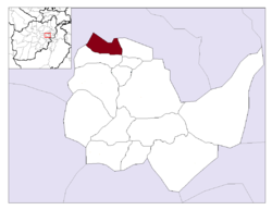
Location in Kabul Province
Country Flag of the Taliban.svg  Afghanistan
Province Kabul Province
Capital Istalif
Population
 (2015)
  Total34,322
Time zone UTC+04:30

Istalif District is located in the northwestern part of Kabul Province, Afghanistan. It has a population of 8,500 (2002 official UNHCR est.), a mixture of Tajiks, Pashtuns and Hazaras. [1]

Istalif district borders Parvan Province to the north and west, Qarabagh District to the east and Guldara District to the south. The district capital is the village of Istalif, situated in the southeastern part of the district.

The villages of the district used to have a population of about 36,000 people, and were filled with fruit trees, vineyards, and vegetable gardens. But when the villages were destroyed, thousands fled for their lives, leaving behind ghost settlements in the continuing wars. All agricultural, health and education infrastructures were destroyed. New schools and a health center have been built in the last few years. Many houses had been rebuilt and the bazaar is alive.

Related Research Articles

Qarabagh District, Kabul District in Kabul Province, Afghanistan

Qarabagh District is located 50 kilometers north of Kabul City in Afghanistan, and 20 kilometers southeast of Bagram Airbase. The district is part of Kabul Province and is on the route between Kabul and Parwan Province. It has a population of 15,000, with an expected 19,000 more people to return from Pakistan and Iran in the future. As of 2002 around 60% of the population are Tajiks and 40% Pashtuns.

Achin District District in Nangarhar Province, Afghanistan

Achin is a district in southern Nangarhar Province, Afghanistan, on the border with Pakistan.

Goshta District District in Nangarhar Province, Afghanistan

Goshta District is located in the northeast of Nangarhar Province, Afghanistan and borders Durand Line between Afghanistan and Pakistan. The district's population is Pashtun and was estimated at 160,000 in 2002, of whom 30,000 were children under 12. The district is within the heartland of the Mohmand tribe of Pashtuns. The district centre is the village of Goshta, on the Kabul River.

Hesarak District District in Nangarhar Province, Afghanistan

Hesarak or Hisarak ولسوالی حصارک is a district in the west of Nangarhar Province, Afghanistan. Its population was estimated at 28,462 in 2002. The district centre is the village of Hesarak.

Surkh-Rōd.(Pashto/Persian: سرخ‌رود/ سره رود), also spelled as Surkh-Rūd or Sorkh-Rūd, also called Sra-rod or Sra- road, is a district in the north of Nangarhar Province, Afghanistan. The district centre is the town of Sultanpur. It is well known to locals because of its abundance of fertile land, however it is currently facing a lack of water.

Andarab district is located in the southern part of Baghlan Province, Afghanistan. The estimated population of Andarab in 2004 was roughly 120,642. In 2002, it was estimated that Tajiks made up 100% of the district's population. The district centre is the village of Andarab, which is named after the Andarab valley in which it is located.

Pasaband District is located in Ghor Province, Afghanistan. The population is 92,900. Located in the southern part of Ghor Province, Pasaband District borders Helmand Province to the south, Daykundi Province to the east, and Farah Province to the southwest. The district center is Shinkot.

Deh Sabz District District in Kabul Province, Afghanistan

Deh Sabz District is situated northeast of Kabul City in Afghanistan. It has a population of 100,136 people. About 70% are Pashtuns and 30% are Tajiks.

Guldara is a village and the center of Guldara District, Kabul Province, Afghanistan. It is located at 34.8172°N 69.0878°E at 1722 m altitude, 45 km North of Kabul. The village was almost fully destroyed and now is continuing the process of rehabilitation. A new clinic has been opened. A local NGO, Afghan Educational and Rehabilitation Organisation (AERO) is running this clinic which will provide family planning, child and general health services to a population of around 38,000 people.

Mussahi District District in Kabul Province, Afghanistan

Mussahi District is a southern district of Kabul Province, Afghanistan. Mussai district borders Char Asiab District to the west, Bagrami District to the north, Khaki Jabbar District to the east and Logar Province to the south. Its headquarter is in Mussahi village, which is in the central part of the district.

Paghman District District in Kabul Province, Afghanistan

Paghman District is in the western part of Kabul Province, Afghanistan. It has a population of over 120,000 people.

Surobi District, Kabul District in Kabul Province, Afghanistan

Surobi, Sarobi, or Sarubi District is a district of Kabul Province, Afghanistan. Its capital, Surobi, lies about 60 kilometres east of Kabul along the A01 highway, although much of the district lies northeast of Kabul. Surobi is famous all over Afghanistan as it is birthplace to Faisal Babakarkhail a well known Jihadi commander famous for his bravery and courage against Soviet Troops. Its principal river is the Kabul River.

Alingar District

Alingar District is located approximately 27 km from Mehtarlam, the provincial capital of Laghman Province and borders with Alishing and Dawlat Shah districts to the West, Nuristan Province to the North, Kunar and Nangarhar provinces to the East and Qarghayi and Mihtarlam districts to the South.It has about 60 villages located in four main valleys. The population is 85,600 (2006) - 70% of them Pashtun, 20% Pashai and 5% Tajik. The district center is the village of Shahi, located on 34.8347°N 70.3603°E at 915 m altitude. in the valley of the Alingar River, which crosses the district and is the main source of irrigation. The security situation is reported to be relatively stable, although there are some private disputes. The district is reported free of mines.

Mihtarlam District District in Laghman Province, Afghanistan

Mihtarlam District is located in the center of Laghman Province and consists of the urban centre and provincial capital Mihtarlam and 24 major villages and 269 sub-villages.

Qarghayi District District in Laghman Province, Afghanistan

Qarghayi District has 60 villages. It is the largest district in Laghman Province, and is located 30 km from the provincial centre of Mihtarlam. It borders Mihtarlam District to the north, Alingar District to the northeast, Nangarhar Province to the south and Kabul Province to the west. The district center is the village of Lalkhanabad, located between the Kabul River and its tributary the Alingar River.

Dangam District

Dangam District is situated in the eastern end of Kunar Province in Afghanistan. It borders Marawara district to the southwest, Asadabad district to the west, Bar Kunar district to the north, Nari district to the northeast and Khyber Pakhtunkhwa in Pakistan to the east. The district is mountainous and stunning but also poor.

Khas Kunar District

Khas Kunar or Sarkani(sarkano) District is the largest district in the Kunar Province, Afghanistan. It is situated in the southern part of the province and borders Nangarhar Province to the south and Pakistan to the east. The Kunar River passes north through the district and irrigates the surrounding land. The population was estimated to be 31,000 in 2006. The district center, Khas Kunar village is located at 34.6458°N 70.9008°E at 749 m altitude. Most of the houses were destroyed during the wars and droughts also have seriously affected the lands all around the Kunar River. The most influential person from this district was Kabir Stori, who was a Pashtun nationalist.

Khokhi District is located in the East part of Logar Province, Afghanistan. 80 km away from Kabul and 18 km from Pul-i-Alam centre of Logar Province. Centre of the district is called Khoshi. Pashtuns make up 65% of the population, Tajiks 34% and Hazara 1%.

Mohammad Agha District Place in Logar Province, Afghanistan

Mohammad Agha District is a district of Logar Province, Afghanistan. It lies just south of Kabul Province. The district capital is Mohammad Agha. The Afghan government plans to build a new international airport in this district.

Dara-I-Pech District District of Kunar Province, Afghanistan

Dara-I-Pech District is located in western-central Kunar Province, Afghanistan, 30 km west of Asadabad. The population was 48,400 in 2006. The district is governed from Mano Gai. The governor is Mohammad Rahkman.

References

Coordinates: 34°49′59″N69°04′37″E / 34.833°N 69.077°E / 34.833; 69.077