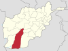
Helmand, also known as Hillmand, in ancient times, as Hermand and Hethumand, is one of the 34 provinces of Afghanistan, in the south of the country. It is the largest province by area, covering 58,584 square kilometres (20,000 sq mi) area. The province contains 18 districts, encompassing over 1,000 villages, and roughly 1,446,230 settled people. Lashkargah serves as the provincial capital. Helmand was part of the Greater Kandahar region until made into a separate province by the Afghan government in the 20th century.
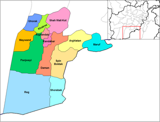
Panjwayi is a district in Kandahar Province, Afghanistan. It is located about 35 kilometres (22 mi) west of Kandahar. The district borders Helmand Province to the southwest, Maywand District to the west, Zhari District to the north, Arghandab, Kandahar and Daman districts to the east and Reg District to the south. Panjwayi was reduced in size in 2004 when Zhari District was created out of the northern part of it, on the northern side of the Arghandab River, which now forms the northern boundary.
Grishk District, also called Nahri Saraj District, is a district in Helmand Province in southern Afghanistan. Its principal municipality is Grishk. Grishk Dam is located in the district.
Nawa is a large district in the far south of Ghazni Province, Afghanistan. It is 100 km south from Ghazni in a mountainous region. The salt lake Ab-i Istada is located in the northern part of the district. Nawa's population was estimated at 29,054 in 2002, of whom around 45% were children under 12. The district center is the village of Nawa. Military operations in the district were featured in articles in the Washington Post and the New York Times in October 2009. The district was controlled by the Taliban until 17 July 2017.

Nawzad is a district in the north of Helmand Province, Afghanistan. Its population, which is 100% Pashtun, was estimated at 49,500 in 2012. The district centre is the village of Nawzad; there are 14 other large villages and over 100 smaller villages.
Musa Qala is a district in the north of Helmand Province, Afghanistan. Its population was around 57,500 in 2012 and are 97% ethnic Pashtun. The district centre is the village of Musa Qala; there are 19 other large villages and 200 smaller settlements, mostly along the Musa Qala River. The area is irrigated by the Helmand and Arghandab Valley Authority.
Lashkargah is a district in the east of Helmand Province, Afghanistan, surrounding the provincial capital of Lashkargah. Its population is 99% Pashtun and 0.2% Baluch, with, 0.8% are Hindus and Hazara; the population was estimated at 43,934 in 2018. Hilmand is mainly a desert and dry province.

Kajaki(Pashto: کجکی) is a district in the Northeast of Helmand Province, Afghanistan. Its population is by a vast majority Pashtun, and stood at 69,300 in 2012. The district centre is the village of Kajaki. Route 611 passes through the district to the district center.

Nad Ali or Nad-e Ali is a district in Helmand Province, Afghanistan. Marja is an unincorporated agricultural district in Nad Ali. The area is irrigated by the Helmand and Arghandab Valley Authority (HAVA). A small town of the same name lies 11 km to the west of the Helmand River, at the coordinates shown at the top of the page. The town of Nad-e Ali was built in 1954 as part of the HAVA irrigation project, and was settled by 3,000 predominantly Pashtun families who were given newly arable land.

Washir is a district in the west of Helmand Province, Afghanistan. Its population was reported in 2012 as 15,200, from the Pashtun ethnic group believed to be of Noorzai tribe. The district centre is the village of Washir. The district of Washer borders Farah province to the north and is 80 kilometres south of Lashkar Gah.

Sangin is a district in the east of Helmand Province, Afghanistan. Its population was reported at 58,100 in 2012, all of which belong to Pashtun ethnic group. The district centre is the town of Sangin. The area is irrigated by the Helmand and Arghandab Valley Authority.

Gizab also spelled as Gezab and Gizu, is a district in the Daykundi Province of Afghanistan. It has a population of about 75,503 and includes Hazara and Pashtun ethnic groups. The main town Gizab is at 1364 m altitude along the Helmand River.
Pasaband District is located in Ghor province, Afghanistan. The population is 92,900. Located in the southern part of Ghor province, Pasaband District borders Helmand province to the south, Daykundi province to the east, and Farah province to the southwest. The district center is Shinkot.
The village of Dishu is the center of Dishu District in Helmand Province, Afghanistan. Like other settlements in the district, it is located near the Helmand River on 30.4344°N 63.3183°E at 598 m altitude. The population was 9,482 according to calculations for 2007.

Nāwa-I-Barakzāyi District is an administrative district in Helmand Province, Afghanistan located south of the provincial capital of Lashkar Gah along the Helmand River. It is bordered by the districts of Lashkar Gah, Nad Ali, Garmsir, and Rig, as well as the provinces of Nimruz and Kandahar. It falls within the area known as Pashtunistan,, an area comprising most of southeast Afghanistan and northwest Pakistan. The dominant language is Pashto and many of the 89,000 residents practice the traditional code of Pashtunwali. Nawa-I-Barakzayi's name reflects the dominant Pashtun tribe in the district, the Barakzai. Prior to the 1970s, it was called Shamalan after a small village at the south end of the district
Garmsir District is located in the southern part of Helmand Province, Afghanistan. The district is large, but all the villages are along the Helmand River. The rest is a desert. The district capital, Garmsir, is located in the northwestern part of the district on the east bank of Helmand River.

Reg (Khanashin) District is situated in the southeastern part of Helmand Province, Afghanistan along the Helmand River on its western bank. The population is 25,600. The main village is Khanashin.
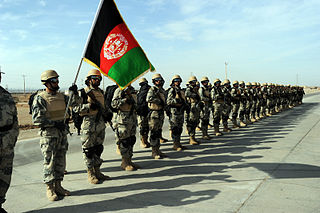
The Afghan Border Force (ABF) was responsible for security of Afghanistan's border area with neighboring countries extending up to 30 miles (48 km) into the interior and formed part of the Afghan National Army. In December 2017, most of the Afghan Border Police (ABP) personnel of the Afghan National Police were transferred to the Afghan National Army to form the Afghan Border Force. The ABP retained 4,000 personnel for customs operations at border crossings and international airports such as checking documents of foreigners entering the country or deporting them.