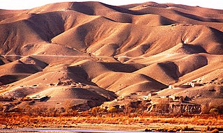
The Helmand River is the longest river in Afghanistan and the primary watershed for the endorheic Sistan Basin. It emerges in the Sanglakh Range of the Hindu Kush mountains in the northeastern part of Maidan Wardak Province, where it is separated from the watershed of the Kabul River by the Unai Pass. The Helmand feeds into the Hamun Lake on the border between Afghanistan and Iran.
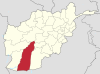
Helmand, also known as Hillmand, in ancient times, as Hermand and Hethumand, is one of the 34 provinces of Afghanistan, in the south of the country. It is the largest province by area, covering 58,584 square kilometres (20,000 sq mi) area. The province contains 13 districts, encompassing over 1,000 villages, and roughly 1,446,230 settled people. Lashkargah serves as the provincial capital. Helmand was part of the Greater Kandahar region until made into a separate province by the Afghan government in the 20th century.

Lashkargāh, historically called Bost or Boost, is a city in southwestern Afghanistan and the capital of Helmand Province. It is located in Lashkargah District, where the Arghandab River merges into the Helmand River. The city has a population of 201,546 as of 2006. Lashkargah is linked by major roads with Kandahar to the east, Zaranj on the border with Iran to the west, and Farah and Herat to the north-west. It is mostly very arid and desolate. However, farming does exist around the Helmand and Arghandab rivers. Bost Airport is located on the east bank of the Helmand River, five miles north of the junction of the Helmand and Arghandab rivers. Because of the trading hubs, it is Afghanistan's second largest city in size, after Kabul and before Kandahar.

The districts of Afghanistan, known as wuleswali are secondary-level administrative units, one level below provinces. The Afghan government issued its first district map in 1973. It recognized 325 districts, counting wuleswalis (districts), alaqadaries (sub-districts), and markaz-e-wulaiyat. In the ensuing years, additional districts have been added through splits, and some eliminated through merges. In June 2005, the Afghan government issued a map of 398 districts. It was widely adopted by many information management systems, though usually with the addition of Sharak-e-Hayratan for 399 districts in total. It remains the de facto standard as of late 2018, despite a string of government announcements of the creation of new districts.
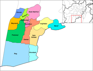
Panjwayi is a district in Kandahar Province, Afghanistan. It is located about 35 kilometres (22 mi) west of Kandahar. The district borders Helmand Province to the southwest, Maywand District to the west, Zhari District to the north, Arghandab, Kandahar and Daman districts to the east and Reg District to the south. Panjwayi was reduced in size in 2004 when Zhari District was created out of the northern part of it, on the northern side of the Arghandab River, which now forms the northern boundary.
Nawa is a large district in the far south of Ghazni Province, Afghanistan. It is 100 km south from Ghazni in a mountainous region. The salt lake Ab-i Istada is located in the northern part of the district. Nawa's population was estimated at 29,054 in 2002, of whom around 45% were children under 12. The district center is the village of Nawa. Military operations in the district were featured in articles in the Washington Post and the New York Times in October 2009. The district was controlled by the Taliban until 17 July 2017.
Sher Mohammed Akhundzada is a tribal leader who was the Governor of Helmand in Afghanistan from 2001 to 2005.
Dishu is a district in the south of Helmand Province, Afghanistan, bordering Pakistan. Its population, which is 80% Pashtun and 20% Baloch, was estimated at 19,900 in 2012. The district centre is the village of Dishu; most of the settlements in the district are along the Helmand River. The other important town is Bahramcha.
Musa Qala is a district in the north of Helmand Province, Afghanistan. Its population was around 57,500 in 2012 and are 97% ethnic Pashtun. The district centre is the village of Musa Qala; there are 19 other large villages and 200 smaller settlements, mostly along the Musa Qala River. The area is irrigated by the Helmand and Arghandab Valley Authority.

Nāwa-I-Barakzāyi District is an administrative district in Helmand Province, Afghanistan located south of the provincial capital of Lashkar Gah along the Helmand River. It is bordered by the districts of Lashkar Gah, Nad Ali, Garmsir, and Rig, as well as the provinces of Nimruz and Kandahar. It falls within the area known as Pashtunistan,, an area comprising most of southeast Afghanistan and northwest Pakistan. The dominant language is Pashto and many of the 89,000 residents practice the traditional code of Pashtunwali. Nawa-I-Barakzayi's name reflects the dominant Pashtun tribe in the district, the Barakzai. Prior to the 1970s, it was called Shamalan after a small village at the south end of the district
Garmsir District is located in the southern part of Helmand Province, Afghanistan. The district is large, but all the villages are along the Helmand River. The rest is a desert. The district capital, Garmsir, is located in the northwestern part of the district on the east bank of Helmand River.

Reg (Khanashin) District is situated in the southeastern part of Helmand Province, Afghanistan along the Helmand River on its western bank. The population is 25,600. The main village is Khanashin.

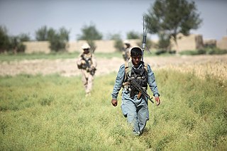
Operation Strike of the Sword or Operation Khanjar was a US-led offensive in Helmand province in southern Afghanistan. About 4,000 Marines from the 2nd Marine Expeditionary Brigade as well as 650 Afghan troops were involved, supported by NATO planes. The operation began when units moved into the Helmand River valley in the early hours of July 2, 2009. This operation was the largest Marine offensive since the Battle of Fallujah in 2004. The operation was also the biggest offensive airlift by the Marines since the Vietnam War.

Patrol Base Jaker in Afghanistan was a military expeditionary base used by the United States Marine Corps and British Army. It was in along the Helmand River Valley in Nawa-I-Barakzayi. It was originally built by the British Army of Task Force Helmand in 2008. In June 2009, it was transferred to the Marines of 2nd Marine Expeditionary Brigade. It was also the setting for the documentary film Patrol Base Jaker.

FOB Geronimo is a former Forward operating base located along the Helmand River Valley in Nawa-I-Barakzayi District, Helmand Province, Afghanistan. It was originally built for 1st Battalion, 5th Marines by Combat Logistics Battalion 8 (CLB8), of the United States Marine Corps in 2009.
Fiddler's Green was an expeditionary fire base in Afghanistan built by the United States Marine Corps. It was located off Route 605 in Nawa-I-Barakzayi District of Helmand Province. It was originally built by the 3d Battalion, 11th Marines in 2009 for Operation Strike of the Sword.

Route 608 is the main road between Garmsir District and Lashkar Gah, the Capital of Helmand Province, Afghanistan. This 71 kilometer road goes through Nawa-I-Barakzayi District Center and Marja. In 2008, United States Agency for International Development initiated a US$10,000,000 project to upgrade the road to compacted gravel, but the improvements were largely halted due to Operation Strike of the Sword.