Sangin سنگین | |
|---|---|
District | |
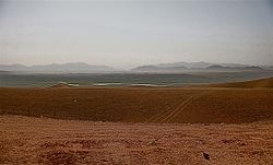 The now closed Georgian ISAF Combat Outpost Shukvani in Helmand province, Afghanistan, which sits on a plateau overlooking the city of Sangin. | |
 Sangin | |
| Coordinates: 32°04′24″N64°50′16″E / 32.0733°N 64.8378°E | |
| Country | |
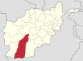
| Province | Helmand Province |
| Population (2012) [1] | |
• Total | 58,100 |
Sangin [2] is a district in the east of Helmand Province, Afghanistan. Its population was reported at 58,100 [1] in 2012, all of which belong to the Pashtun ethnic group. The district centre is the town of Sangin. The area is irrigated by the Helmand and Arghandab Valley Authority. [3]