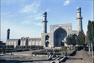
Herāt is an oasis city and the third-largest city in Afghanistan. In 2020, it had an estimated population of 574,276, and serves as the capital of Herat Province, situated south of the Paropamisus Mountains in the fertile valley of the Hari River in the western part of the country. An ancient civilization on the Silk Road between West Asia, Central Asia, and South Asia, it serves as a regional hub in the country's west.

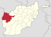
Herat is one of the thirty-four provinces of Afghanistan, located in the western part of the country. Together with Badghis, Farah, and Ghor provinces, it makes up the north-western region of Afghanistan. Its primary city and administrative capital is Herat City. The province of Herat is divided into about 17 districts and contains over 2,000 villages. It has a population of about 3,780,000, making it the second most populated province in Afghanistan behind Kabul Province. The population is multi-ethnic but largely Persian-speaking. Herat dates back to the Avestan times and was traditionally known for its wine. The city has a number of historic sites, including the Herat Citadel and the Musalla Complex. During the Middle Ages Herat became one of the important cities of Khorasan, as it was known as the Pearl of Khorasan.

Farah is one of the 34 provinces of Afghanistan, located in the southwestern part of the country next to Iran. It is a spacious and sparsely populated province, divided into eleven districts and contains hundreds of villages. It has a population of about 563,026, which is multi-ethnic and mostly a rural tribal society. The Farah Airport is located near the city of Farah, which serves as the capital of the province. Farah is linked with Iran via the Iranian border town of Mahirud. The province famous tourism sites include Pul Garden, New Garden, Kafee Garden, shrine of Sultan Amir and Kafer castle are from sightseeing places of Farah province
Adraskan is a district in the central part of Herat Province in Afghanistan. It is bordered to the west by Iran, to the north by Ghoryan District, Zinda Jan District, Guzara District, Pashtun Zarghun District and Obe District, to the east by Farsi District and to the south by Shindand District.

Chishti Sharif District, also known as Chisht District, is the most easterly district in Herat Province, Afghanistan, situated along the Hari River and one of its northern tributaries. It borders with Obe District to the west, Badghis Province to the north and Ghor Province to the east and south. The population was estimated at 23,100 in 2012. The district administrative center is the village of Chishti Sharif.
Farsi is a district the west of Herat Province, Afghanistan. It borders on Obe District to the north, Adraskan District to the west, Shindand District to the south and Ghor Province to the south and east. The population was estimated at 29,800 in 2012. The district center is the village of Farsi.
The Ghurian District is an Afghan administrative district (Wuleswali) in far western Afghanistan in western Herat Province. The district is bordered by Iran to the west and northwest. It is then bordered by other districts of Herat, Kohsan District in the north, Zendeh Jan District to the east, and Adraskan District to the south. The Hari River flows through the northeastern end of the district. The border with Iran is marshy. The population is 85,900 and the district center is the city of Ghurian.
Guzara (Gozareh) District is situated in the center of Herat Province, Afghanistan, 10 km south of Herat. It borders Injil District to the north, Pashtun Zarghun District to the east, Adraskan District to the south and Zinda Jan District to the west. The district center Guzara (Gozareh) is on the main road Herat-Kandahar.
Injil is a district of Herat Province in northwestern Afghanistan. It surrounds Herat City and borders Kushk District to the north, Karukh District to the east, Guzara District to the South, and Zinda Jan District to the west. There is no any official census from this district, therefor all the numbers are based on approximately the population of different localities in the district. The population of Injil District is around 237,800, which includes the following ethnic groups: Around 55% Tajik, around 40% Pashtun. Almost all inhabitants of Jebrael locality are Hazara. Jebrael has a population of around 60-80 thousand people. This makes the population of Hazara in Injil district around 4% and 1% Turkmen.
Karukh District is situated in the northeastern part of Herat Province, Afghanistan. It borders Kushk District to the northwest, Kushki Kuhna District to the north and Badghis Province to the northeast. To the east is Obe District. To the south is Pashtun Zarghun District and Injil District is situated to the west. The population is 62,000. The district center is the town of Karukh.
Kohsan is a district of Herat province in northwestern Afghanistan. It borders the nation of Iran to the west, Gulran District to the north, and Ghurian District to the south and east. The population of Kosan District is 52,900, which includes the following ethnic groups: 59.4% Pashtun, 35.3% Tajik, 5.1% Balouch, and 0.2% Turkmen.

Kushk District is situated in the northern part of Herat Province, Afghanistan and also may be referred to as Rubat-i-Sangin or Rabat-e-Sangi. It borders Turkmenistan to the north, Gulran District to the west, Zinda Jan District, Injil District and Karukh District to the south and Kushki Kuhna District to the east. The population is 121,000 (2012).
Kushki Kuhna is a district of Herat province in northwestern Afghanistan. It is situated in the northern part of the province. It borders Kushk District to the west, the nation of Turkmenistan to the north, Badghis Province to the east, and Karukh District to the south. The population Kushki Kuhna is 44,400, which includes the following ethnic groups: 55% Tajik, 40% Pashtun and 5% Hazara.
Obe is a district in the northeast of Herat Province, Afghanistan. It borders on the north with Badghis Province, on the east with Chishti sharif District, on the southeast with Farsi District, on the south with Adraskan District, and on the west with Pashtun Zarghun and Karukh districts.
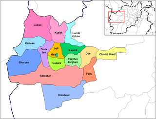
Shinḍanḍ District is located in the southern part of Herat Province in Afghanistan, bordering Adraskan District to the north, Ghor Province to the east and Farah Province to the south and west. It is one of the 16 districts of Herat Province. The name Shindand is Pashto and relates to lush green farming area. In Persian language it translates to Sabzwār.
The Zinda Jan District is located in the central part of Herat Province in Afghanistan. It borders Gulran and Kushk districts to the north, Injil and Guzara districts to the east, Adraskan District to the south and Ghoryan and Kohsan districts to the west. The population is 55,500. The district center is the town of Zendeh Jan, situated in the valley of the Hari River.

Bādghīs is one of the thirty-four provinces of Afghanistan, located in the northwest of the country, on the border with Turkmenistan. It is considered to be one of the country's most underdeveloped provinces, with the highest poverty rate. The capital is Qala e Naw, while the most populous city and the district are Bala Murghab. The ruins of the medieval city of Marw al-Rudh, the historical capital of the medieval region of Gharjistan, are located in the province near the modern city of Bala Murghab.
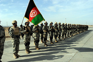
The Afghan Border Force (ABF) was responsible for security of Afghanistan's border area with neighboring countries extending up to 30 miles (48 km) into the interior and formed part of the Afghan National Army. In December 2017, most of the Afghan Border Police (ABP) personnel of the Afghan National Police were transferred to the Afghan National Army to form the Afghan Border Force. The ABP retained 4,000 personnel for customs operations at border crossings and international airports such as checking documents of foreigners entering the country or deporting them.
Herat District is a district of Herat Province, Afghanistan. The capital lies at Herat city. In 2019 the estimated population was 556,205.
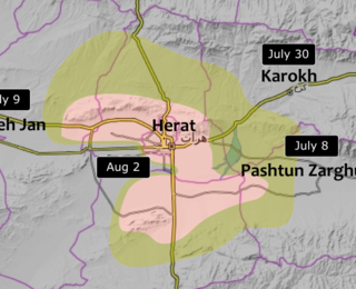
The Fall of Herat was a battle and subsequent capture of Herat by Taliban fighters. The attack on the city started around 28 July 2021, and ended in Taliban victory by 13 August of the same year. Several of the surrounding districts fell to the Taliban from June to mid-July, leaving only the city and two other districts in government hands by 10 July. The border crossings in Herat Province were captured by the Taliban on 9 July, raising prices of goods inside the city. Ismail Khan, former governor and warlord, led a public uprising force to assist the Afghan National Security Forces in defending the city.