Zabul Province زابل | |
|---|---|
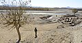
Landscape of Zabul Province Children attending a jirga Shahjoy landscape Young villager watches coalition troops pass in Shamulzayi Almond trees in Zabul | |
 Map of Afghanistan with Zabul highlighted | |
| Coordinates: 32°06′N67°06′E / 32.1°N 67.1°E | |
| Country | |
| Capital | Qalat |
| Government | |
| • Governor | Mullah Bismillah Abdullah [1] |
| • Deputy Governor | Abdul Khaliq Abid [1] |
| Area | |
• Total | 17,471 km2 (6,746 sq mi) |
| Population (2021) [4] | |
• Total | 391,150 |
| • Density | 22.389/km2 (57.986/sq mi) |
| Time zone | UTC+4:30 (Afghanistan Time) |
| Postal code | 40xx |
| ISO 3166 code | AF-ZAB |
| Main languages | Pashto |


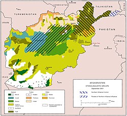
Zabul Province [a] is one of the 34 provinces of Afghanistan, located in the south of the country. It has a population of 249,000. [4] Zabul became a separate province from neighbouring Kandahar in 1963. Historically, it was part of the Zabulistan region. Qalat serves as the capital of the province. The major ethnic group are Pashtuns. Primary occupations within Zabul are agriculture and animal husbandry.
Contents
- Geography
- Administrative divisions
- Economy
- Demographics
- Population
- Ethnicity, languages and religion
- Education
- Health
- Culture
- Sports
- Gallery
- Notable people
- See also
- Notes
- References
- External links
According to Iranic legend, Zabul is the birthplace of the hero Rostam. [5]