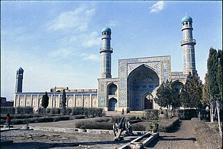
Herāt is an oasis city and the third-largest city in Afghanistan. In 2020, it had an estimated population of 574,276, and serves as the capital of Herat Province, situated south of the Paropamisus Mountains in the fertile valley of the Hari River in the western part of the country. An ancient civilization on the Silk Road between West Asia, Central Asia, and South Asia, it serves as a regional hub in the country's west.

Transport in Afghanistan is done mostly by road, rail and air. Much of the nation's road network was built in the mid-20th century but left to ruin during the last two decades of that century due to war and political turmoil. Officials of the current Islamic Emirate have continued to improve the national highways, roads, and bridges. In 2008, there were about 700,000 vehicles registered in Kabul. At least 1,314 traffic collisions were reported in 2022.
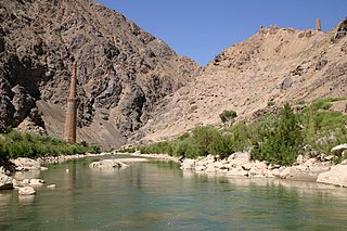
The Hari River or Herat River or Tejen River or Harirud is a river flowing 1,100 kilometres (680 mi) from the mountains of central Afghanistan to Turkmenistan, where it forms the Tejen oasis and disappears in the Karakum Desert. In its lower course, the river forms a northern part of the border between Afghanistan and Iran, and a southeastern part of the border between Turkmenistan and Iran.

Herat is one of the thirty-four provinces of Afghanistan, located in the western part of the country. Together with Badghis, Farah, and Ghor provinces, it makes up the north-western region of Afghanistan. Its primary city and administrative capital is Herat City. The province of Herat is divided into about 17 districts and contains over 2,000 villages. It has a population of about 3,780,000, making it the second most populated province in Afghanistan behind Kabul Province. The population is multi-ethnic but largely Persian-speaking. Herat dates back to the Avestan times and was traditionally known for its wine. The city has a number of historic sites, including the Herat Citadel and the Musalla Complex. During the Middle Ages Herat became one of the important cities of Khorasan, as it was known as the Pearl of Khorasan.

Faryab is one of the thirty-four provinces of Afghanistan, which is located in the north of the country bordering neighboring Turkmenistan. It has a population of about 1,109,223, which is multi-ethnic and mostly a tribal society. The province encompasses 15 districts and over 1,000 villages. The capital of Faryab province is Maymana. It also borders Jowzjan Province, Sar-e Pol Province, Ghor Province and Badghis Province.

Chaghcharān, also called Firozkoh, is a town and district in central Afghanistan, which serves as the capital of Ghor Province. It is located on the southern side of the Hari River, at an altitude of 2,230 m above sea level. Chaghcharan is linked by a 380 kilometres (240 mi) long highway with Herat to the west, and a 450 kilometres (280 mi) long highway with Kabul to the east. The town has an airport called Chaghcharan Airport.

Qala-e-Naw is a town in Qala e Naw District and the capital of Badghis Province, in north-west Afghanistan. Its population was estimated at 9,000 in 2006, of which mostly Sunni Hazaras. Other significant communities include Tajiks, Pashtuns, Balochs, and Uzbeks.
Adraskan is a district in the central part of Herat Province in Afghanistan. It is bordered to the west by Iran, to the north by Ghoryan District, Zinda Jan District, Guzara District, Pashtun Zarghun District and Obe District, to the east by Farsi District and to the south by Shindand District.
The Ghurian District is an Afghan administrative district (Wuleswali) in far western Afghanistan in western Herat Province. The district is bordered by Iran to the west and northwest. It is then bordered by other districts of Herat, Kohsan District in the north, Zendeh Jan District to the east, and Adraskan District to the south. The Hari River flows through the northeastern end of the district. The border with Iran is marshy. The population is 85,900 and the district center is the city of Ghurian.
Kohsan is a district of Herat province in northwestern Afghanistan. It borders the nation of Iran to the west, Gulran District to the north, and Ghurian District to the south and east. The population of Kosan District is 52,900, which includes the following ethnic groups: 59.4% Pashtun, 35.3% Tajik, 5.1% Balouch, and 0.2% Turkmen.
Kushki Kuhna is a district of Herat province in northwestern Afghanistan. It is situated in the northern part of the province. It borders Kushk District to the west, the nation of Turkmenistan to the north, Badghis Province to the east, and Karukh District to the south. The population Kushki Kuhna is 44,400, which includes the following ethnic groups: 55% Tajik, 40% Pashtun and 5% Hazara.
Obe is a district in the northeast of Herat Province, Afghanistan. It borders on the north with Badghis Province, on the east with Chishti sharif District, on the southeast with Farsi District, on the south with Adraskan District, and on the west with Pashtun Zarghun and Karukh districts.
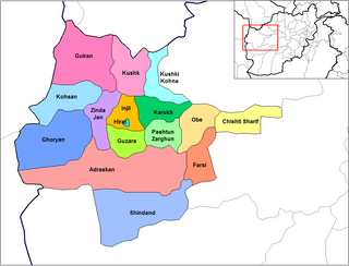
Shinḍanḍ District is located in the southern part of Herat Province in Afghanistan, bordering Adraskan District to the north, Ghor Province to the east and Farah Province to the south and west. It is one of the 16 districts of Herat Province. The name Shindand is Pashto and relates to lush green farming area. In Persian language it translates to Sabzwār.
Shibirghan is a district situated in the southern part of Jowzjan province in Afghanistan. It borders Faryab province to the west, Khwaja du koh District to the north, Aqcha District to the east and Sar-e Pol province. The population is 188,808 (2019). The center is the provincial capital Sheberghan. There are main roads from the district center towards Herat, Kabul, Andkhoy and Mazari Sharif. Sheberghan airfield is situated between Sheberghan and Aqchah.

Wali Kirani was a Muslim saint. His date of birth and date of death are not known, but is believed to have lived around the time of Sultan Hussain Mirza's rule in Herat around 1470.

Bādghīs is one of the thirty-four provinces of Afghanistan, located in the northwest of the country, on the border with Turkmenistan. It is considered to be one of the country's most underdeveloped provinces, with the highest poverty rate. The capital is Qala e Naw, while the most populous city and the district are Bala Murghab. The ruins of the medieval city of Marw al-Rudh, the historical capital of the medieval region of Gharjistan, are located in the province near the modern city of Bala Murghab.
Afghan-India Friendship Dam (AIFD), formerly Salma Dam, is a hydroelectric and irrigation dam project located on the Hari River in Chishti Sharif District of Herat Province in western Afghanistan. The Afghan cabinet had renamed the Salma Dam to the Afghan-India Friendship Dam to express gratitude to India, which funded and helped with completing the partially constructed project.

Chishti Sharif is a town situated on the northern bank of the Hari River in Herat Province, Afghanistan. It is the administrative center of Chishti Sharif District.
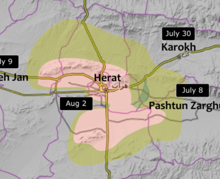
The Fall of Herat was a battle and subsequent capture of Herat by Taliban fighters. The attack on the city started around 28 July 2021, and ended in Taliban victory by 13 August of the same year. Several of the surrounding districts fell to the Taliban from June to mid-July, leaving only the city and two other districts in government hands by 10 July. The border crossings in Herat Province were captured by the Taliban on 9 July, raising prices of goods inside the city. Ismail Khan, former governor and warlord, led a public uprising force to assist the Afghan National Security Forces in defending the city.