Related Research Articles

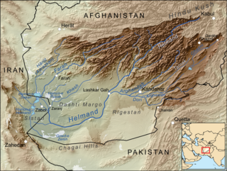
The Helmandriver, also spelled Helmend, or Helmund, Hirmand, is the longest river in Afghanistan and the primary watershed for the endorheic Sistan Basin. It originates in the Sanglakh Range of the Hindu Kush mountains in the northeastern part of Maidan Wardak Province, where it is separated from the watershed of the Kabul River by the Unai Pass. The Helmand feeds into the Hamun Lake on the border of Afghanistan and Iran.

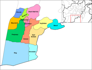
Panjwayi is a district in Kandahar Province, Afghanistan. It is located about 35 kilometres (22 mi) west of Kandahar. The district borders Helmand Province to the southwest, Maywand District to the west, Zhari District to the north, Arghandab, Kandahar and Daman districts to the east and Reg District to the south. Panjwayi was reduced in size in 2004 when Zhari District was created out of the northern part of it, on the northern side of the Arghandab River, which now forms the northern boundary.

Surobi, Sarobi, or Sarubi District is a district of Kabul Province, Afghanistan. Its capital, Surobi, lies about 60 kilometres east of Kabul along the A01 highway, although much of the district lies northeast of Kabul. Surobi is famous all over Afghanistan as it is birthplace to Faisal Babakarkhail a well known Jihadi commander famous for his bravery and courage against Soviet Troops. Its principal river is the Kabul River.

The town of Arghandab is the center of Arghandab District in Kandahar Province, Afghanistan, in the valley of Arghandab River northwest from Kandahar. It is located on 31.6547°N 65.6494°E at an elevation of 1,112 metres (3,648 ft).

The Sistan Basin is an inland endorheic basin encompassing large parts of southwestern Afghanistan and minor parts of southeastern Iran. It is one of the driest regions in the world and an area subject to prolonged droughts. Its watershed is a system of rivers flowing from the highlands of Afghanistan into freshwater lakes and marshes and then to its ultimate destination: Afghanistan's saline Godzareh Depression, part of the extensive Sistan terminal basin. The Helmand River drains the basin's largest watershed, fed mainly by snowmelt from the mountains of Hindu Kush, but other rivers contribute also.

Chakhansur is a district in the Nimruz Province of Afghanistan. It has a population of about 11,165 as of 2004, which includes Baloch that form the majority followed by Tajik, Pashtun ethnic groups.

Chahar Burjak District is a district of Nimruz Province in Afghanistan. At just under 22,000 square kilometres (8,500 sq mi) in area, it is the largest district in Afghanistan. The Kamal Khan Dam is located in this district.

Khash Rod District or Khashrowd is a district of Nimruz Province in Afghanistan. It had a population of 35,381 in 2004, which was 55% ethnic Pashtun, 20% Baloch, 15% Brahui and 10% Tajik. The district capital is Ghorghori.

Abdul Karim Brahui is a former politician in Afghanistan. He last served as Governor of Nimroz Province from 2010 to 2012, and before that he served as a minister in the Cabinet of Afghanistan. From February 2009 to August 2010, Brahui served as Minister of Refugees. In 2004, Brahui was appointed as Minister of Borders and Tribal Affairs.
Zaranj District is a district of Nimruz Province, Afghanistan, containing the provincial capital city of Zaranj.

Route 606, also known as Delaram-Zaranj Highway, also officially designated as NH49, is a 218 km roadway in the Nimruz Province of Afghanistan connecting the Delaram District in Afghanistan to the border of Iran. The opposite way goes towards the south near Zaranj, Afghanistan. It is one of the busiest roads in Afghanistan and provides an important trade route between Iran and the rest of Asia. It was developed by India's Border Roads Organisation.

Kang is a village in Jagharq Rural District, Torqabeh District, Torqabeh and Shandiz County, Razavi Khorasan Province, Iran. At the 2006 census, its population was 1,472, in 354 families.
Kang-e Olya is a village in Zaveh Rural District, in the Central District of Zaveh County, Razavi Khorasan Province, Iran. At the 2006 census, its population was 592, with 140 families.
Kang-e Sofla is a village in Zaveh Rural District, in the Central District of Zaveh County, Razavi Khorasan Province, Iran. At the 2006 census, its population was 763, in 214 families.
Kang is a village in Madvarat Rural District, in the Central District of Shahr-e Babak County, Kerman Province, Iran. At the 2006 census, its population was 178, in 44 families.
Kang o Risheh is a village in Fedagh Rural District, in the Central District of Gerash County, Fars Province, Iran. At the 2016 census, its population was 438, in 91 families.
Kang-e Shir Ali Khan is a village in Jahanabad Rural District, in the Central District of Hirmand County, Sistan and Baluchestan Province, Iran. At the 2006 census, its population was 263, in 53 families.
Kang-e Molla Abdollah is a village in Margan Rural District, in the Central District of Hirmand County, Sistan and Baluchestan Province, Iran. At the 2006 census, its population was 177, in 31 families.
Delaram District is a temporary district of Nimruz Province in Afghanistan. It has a mixed population consisting of ethnic Pashtuns, Baloch, and Tajik. The capital of the district is the city of Delaram.

The capture of Zaranj, the capital of Nimruz Province, Afghanistan, occurred on 6 August 2021. According to local officials, only the National Directorate of Security (NDS) and its forces had put up a fight against the Taliban, but they too eventually surrendered to the Taliban. Local officials had been requesting reinforcements but received no response. Zaranj was the first provincial capital to be taken by the Taliban in their 2021 offensive and the first one to be captured since Kunduz in 2016.
References
- ↑ "Kang District" (PDF). Central Statistics Office Afghanistan. Afghanistan's Ministry of Rural Rehabilitation and Development. United Nations. 2004. Archived from the original on 2014-04-07. Retrieved 2012-07-18.
{{cite web}}: CS1 maint: unfit URL (link)
31°19′26″N61°46′31″E / 31.3240°N 61.7753°E
