Khwaja Bahauddin District

Last updated

Khwaja Bahauddin District
120627-A-LE308-129.jpg
View of Khwaja Bahauddin's urban center
Khwaja Bahauddin District Map.svg
Location of Khwaja Bahauddin in Takhar Province
Coordinates: 37°20′N69°32′E / 37.34°N 69.54°E / 37.34; 69.54
CountryFlag of the Taliban.svg  Afghanistan
Province Takhār Province
Area
[1]
  Total178.2 km2 (68.8 sq mi)
Population
 (2019) [2]
  Total25,852
  Density145/km2 (380/sq mi)
Time zone UTC+4:30 (Afghanistan Standard Time)
Post code
3757 [3]

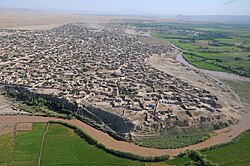
Khwaja Bahauddin District is a district of Takhar Province, Afghanistan. The district was created from a portion of Yangi Qala District in 2005. [4] [5] 25 villages are located in Khwaja Bahauddin. [1]

Contents

Geography

Khwaja Bahauddin has an area of 178.2 square kilometers, comparatively equivalent to Aruba. [6] There is a road connecting the district with Yangi Qala District and Dashti Qala District. [7]

The district is bordered by Yangi Qala District to the north, Rustaq District to the east, Dashti Qala District to the south, and Darqad District to the west. [8] [9]

History

In November 2015, the Taliban launched an attack on the district center. The security forces retreated 6 km toward the district center, and lost 2 policemen, with 6 wounded. [10] Later, in March 2017, the Taliban launched an attack on the district center and set fire to the governor's office before being repulsed. [11] There were 24 security incidents from 1 September 2016 to 31 May 2017, with over 100 families fleeing both Khwaja Bahauddin and Darqad in May 2017. [12] There have been several more security incidents since then. [4]

On 19 May 2020, Taliban insurgents launched attacks on checkpoints in Khwaja Bahauddin District, killing nine pro-government militiamen and wounding six others. [13] [14]

Demographics

Uzbeks, Tajiks, and Pashtuns live in Khwaja Bahauddin. [1] The district has a population of 25852 and a sex ratio of 51 males for every 50 females. The median age is 15.5, and 48.2 percent of the population is employed. About 40% of the unemployed is seeking work. The average household size in Khwaja Bahauddin is 6.9, meaning there are about 3,750 households in the district. [9]

Economy

About half of the people employed in Khwaja Bahauddin are involved in agriculture, hunting, forestry, or fishing. [9] Roughly 40,000 jerib of land is cultivated twice each year and there are farming cooperatives available. However, agricultural output is low because of reliance on traditional farming techniques, lack of modern equipment and cold storehouses, and illegal natural resource use by armed groups.

Forests and mines are also located in the district, but there is a lack of engineers and equipment. [1]

Education and Healthcare

There is limited access to primary and secondary schools in Khwaja Bahauddin, and one religious school. However, there is a lack of teachers, buildings, budget, and training. The district has a 44% literacy rate. [9]

The district has access to some health clinics, including the Iranian Clinic, the Turkish Clinic, and the KAHF Clinic as of 2006. However, there is a lack of funds and a high mortality rate. [1] On 1 March 2020, a health center in the district was closed. [15]

Related Research Articles

<span class="mw-page-title-main">Takhar Province</span> Province of Afghanistan

Takhar is one of the thirty-four provinces of Afghanistan, located in the northeast of the country next to Tajikistan. It is surrounded by Badakhshan in the east, Panjshir in the south, and Baghlan and Kunduz in the west. The city of Taloqan serves as its capital.

<span class="mw-page-title-main">Districts of Afghanistan</span> Second-level administrative subdivision of Afghanistan

The districts of Afghanistan, known as wuleswali, are secondary-level administrative units, one level below provinces. The Afghan government issued its first district map in 1973. It recognized 325 districts, counting wuleswalis (districts), alaqadaries (sub-districts), and markaz-e-wulaiyat. In the ensuing years, additional districts have been added through splits, and some eliminated through merges. In June 2005, the Afghan government issued a map of 398 districts. It was widely adopted by many information management systems, though usually with the addition of Sharak-e-Hayratan for 399 districts in total. It remains the de facto standard as of late 2018, despite a string of government announcements of the creation of new districts.

<span class="mw-page-title-main">Washir District</span> District in Helmand Province, Afghanistan

Washir is a district in the west of Helmand Province, Afghanistan. Its population was reported in 2012 as 15,200, from the Pashtun ethnic group believed to be of Noorzai tribe. The district centre is the village of Washir. The district of Washer borders Farah province to the north and is 80 kilometres south of Lashkar Gah.

<span class="mw-page-title-main">Bangi District</span> District in Takhār Province, Afghanistan

Bangi District is a district of Takhar Province, Afghanistan.

<span class="mw-page-title-main">Chah Ab District</span> District in Takhār Province, Afghanistan

Chah Ab District is a district of Takhar Province, Afghanistan. Its district center is Chah Ab. The district's economy is primarily based on agriculture and livestock.

<span class="mw-page-title-main">Chal District</span> District in Takhār, Afghanistan

Chal District is a district of Takhar Province, Afghanistan. It was considered to be largely under control of the Afghan government in 2018.

<span class="mw-page-title-main">Darqad District</span> District in Takhār Province, Afghanistan

Darqad District is a district of Takhar Province, Afghanistan. The district has 34 villages. Darqad did not change between the 325 and 398 district sets. Near the end of 2018, the district was considered to be Taliban-influenced, as opposed to the Afghan government. The district was Taliban-controlled by August 2021.

<span class="mw-page-title-main">Kalafgan District</span> District in Takhār Province, Afghanistan

Kalafgan District is a district of Takhar Province, Afghanistan. The district is well governed, with self-governance in parts of Kalafgan because of how remote they are. 42 villages are located in the district. In 2017, Kalafgan was considered to be under full control by the Afghan Government. However, the Taliban had taken full control by August 2021.

<span class="mw-page-title-main">Khwaja Ghar District</span> District in Takhār Province, Afghanistan

Khwaja Ghar District is a district of Takhar Province, Afghanistan. The district was badly destroyed during the 1996-2001 Afghan Civil War in fighting between the Taliban and the Northern Alliance.

<span class="mw-page-title-main">Rustaq District, Afghanistan</span> District in Takhār Province, Afghanistan

Rustaq District is a district of Takhar Province, northern Afghanistan. The district centre is the town of Rostaq. As recently as 2020, the district was considered to be under government control, as opposed to control by the Taliban. However, the district has had issues with illegal armed men.

<span class="mw-page-title-main">Yangi Qala District</span> District in Takhār Province, Afghanistan

Yangi Qala District is a district in Takhar Province, Afghanistan. Economically the population of this district is primarily involved in agriculture. The main crops are rice and wheat, and the surplus rice is exporting to neighboring districts and provinces. There are 64 villages in the district. As of August 2021, the Taliban has full control over this district.

<span class="mw-page-title-main">Afghan Border Force</span> Border Guard of Afghanistan

The Afghan Border Force (ABF) was responsible for security of Afghanistan's border area with neighboring countries extending up to 30 miles (48 km) into the interior and formed part of the Afghan National Army. In December 2017, most of the Afghan Border Police (ABP) personnel of the Afghan National Police were transferred to the Afghan National Army to form the Afghan Border Force. The ABP retained 4,000 personnel for customs operations at border crossings and international airports such as checking documents of foreigners entering the country or deporting them.

<span class="mw-page-title-main">Baharak District, Takhar</span> District in Takhār Province, Afghanistan

Baharak District is a district of Takhar Province, Afghanistan. The district was split-off from Taluqan District in 2005. Most people work in agriculture. The district has been the site of fighting between the Afghan Government and the Taliban; Baharak was considered to be contested in late 2018 and taken by the Taliban by August 2021.

<span class="mw-page-title-main">Dashti Qala District</span> District in Takhār Province, Afghanistan

Dashti Qala District is a district of Takhar Province, Afghanistan. It split from Khwaja Ghar District in June 2005. This district borders Tajikistan. Ai-Khanoum, probably founded by the Seleucid Empire, is located in this district. In 2018, this district was considered contested between the government and the Taliban.

<span class="mw-page-title-main">Hazar Sumuch District</span> District in Takhār Province, Afghanistan

Hazar Sumuch District is a district of Takhar Province, Afghanistan. The district was split-off from Taluqan District. Most people in the district work in agriculture. In late 2018, Hazar Sumuch was considered to be government influenced as opposed to the Taliban.

Aqtash District is a district in Kunduz Province, Afghanistan. It was not part of the 399 or 407 district sets, but is recognized in the 422 district set as a temporary district. It was split from Khanabad District in late 2015 after a visit from Ashraf Ghani, the president of Afghanistan. In 2019, only two polling centers were open in the district, with 277 votes cast.

The September 2020 Afghanistan attacks were a series of multiple attacks that occurred in September 2020. Resulting in at least 105 fatalities and another 112 injured. In addition 97 insurgents were killed and another 58 were injured in these attacks.

<span class="mw-page-title-main">Yasin Zia</span> Former Chief of General Staff in Afghanistan

General Mohammad Yasin Zia, is an Afghan military officer and politician. He is a former Chief of General Staff, former Deputy Defense Minister, and former governor of Takhar Province, Afghanistan. Zia has also served as head of Afghanistan's counter terrorism unit (2011) and as the deputy director of the National Directorate of Security (2011–2015). In 2022, he was reported to be one of the leaders of the anti-Taliban Afghanistan Freedom Front resistance movement.

<span class="mw-page-title-main">Republican insurgency in Afghanistan</span> Guerrilla insurgency against Afghanistans Taliban government

The republican insurgency in Afghanistan is an ongoing armed conflict between the National Resistance Front and allied groups which fight under the banner of the Islamic Republic of Afghanistan on one side, and the Islamic Emirate of Afghanistan on the other side. On 17 August 2021, former first vice president of Afghanistan Amrullah Saleh declared himself the "caretaker" president of Afghanistan and announced the resistance. On 26 August, a brief ceasefire was declared. On 1 September, talks broke down and fighting resumed as the Taliban attacked resistance positions.

<span class="mw-page-title-main">Shahjahan Noori</span> Afghan Police Chief (1965–2011)

Shahjahan Noori, also known as General Shahjahan Noori, He was an Afghan guerrilla, military and police commander, during resistance against Soviet invasion and fight against terrorist groups such as Taliban and Al-Qaeda between 1981 and 2011.

References

  1. 1 2 3 4 5 "Summary of District Development Plan: Khwaja Bahauddin" (PDF). mrrd-nabdp.org. Archived from the original (PDF) on 19 April 2014. Retrieved 6 August 2020.
  2. "Estimated population of Afghanistan 2019-2020" (PDF). nsia.gov.af. p. 29. Archived from the original (PDF) on 9 June 2020. Retrieved 6 August 2020.
  3. "Khwaha Bahawuddin Post Codes". worldpostalcodes.com. Retrieved 6 August 2020.
  4. 1 2 "Maps of Afghanistan". arcgis.com. Retrieved 7 August 2020.
  5. "329 to 398 district matching". 2005. Archived from the original on 22 March 2016. Retrieved 7 August 2020.
  6. "Islands by Land Area". unep.ch. 1998. Archived from the original on 16 July 2020. Retrieved 7 August 2020. 181.1 sq. km. Aruba
  7. "Takhar Maps Combined". nps.edu. AIMS. p. 14. Retrieved 7 August 2020.
  8. "Afghanistan Administrative Divisions" (PDF). aims.org. March 2007. Archived from the original (PDF) on 23 September 2010. Retrieved 7 August 2020.
  9. 1 2 3 4 "Takhar Socio-Economic and Demographic Survey" (PDF). unfpa.org. UNFPA . Retrieved 7 August 2020.
  10. "Taliban closing in on Khwaja Bahauddin district: Takhar officials". pajhwok.com. Pajhwok Afghan News. Retrieved 8 August 2020.
  11. "Taliban Attack in Takhar Province". tolonews.com. Retrieved 8 August 2020.
  12. "EASO Country of Origin Information Report Afghanistan Security Situation" (PDF). europa.eu. Retrieved 8 August 2020.
  13. "Fourteen killed in Afghanistan attacks". 20 May 2020. Archived from the original on 7 June 2020. Retrieved 28 May 2020 via www.news.com.au/.
  14. "Afghanistan attacks on eve of US-brokered peace talks underscore scale of challenge". 20 May 2020 via www.theguardian.com/.
  15. "Afghanistan: Weekly Humanitarian Update (24 February – 1 March 2020)". reliefweb.int. 1 March 2020. Retrieved 7 August 2020.