
Khost is one of the 34 provinces of Afghanistan, located in the southeastern part of the country. Khost consists of thirteen districts and the city of Khost serves as the capital of the province. To the east, Khost Province is bordered by North Waziristan and Kurram, which are districts in Pakistan’s Khyber Pakhtunkhwa province. Historically, Khost used to be a part of Paktia, and the larger region surrounding Khost is still referred to as Loya Paktia.

Nangarhār also called Nangrahar or Ningrahar, is one of the 34 provinces of Afghanistan, located in the eastern part of the country and bordering Logar, Kabul, Laghman and Kunar provinces as well as having an international border with Pakistan. It is divided into 22 districts and has a population of about 1,735,531, the third highest of the country's 34 provinces. The city of Jalalabad is the capital of Nangarhar province. Nangarhar province is famous for fish and karaye, and the popular tourist locations Daroonta and Pul-e- Sayad.
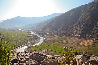
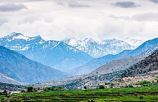
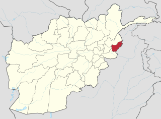
Kunar is one of the 34 provinces of Afghanistan, located in the northeastern part of the country. Its capital is Asadabad. Its population is estimated to be 508,224. Kunar's major political groups include Wahhabis or Ahl-e- Hadith, Nazhat-e Hambastagi Milli, Hezb-e Afghanistan Naween, Hezb-e Islami Gulbuddin.

Bajaur District is a district in Malakand Division of Khyber Pakhtunkhwa province in Pakistan. Until 2018, it was an agency of the Federally Administered Tribal Areas, then during restructuring that merged FATA with Khyber Pakhtunkhwa, it became a district. According to the 2017 census, the population of the district is 1,093,684. It borders Afghanistan's Kunar Province with a 52 km border. The headquarters of the agency administration is located in the town of Khar.

Mohmand District is a district in Peshawar Division of Khyber Pakhtunkhwa province in Pakistan. Until 2018, it was an agency of Federally Administered Tribal Areas, with merger of FATA with Khyber Pakhtunkhwa, it became a district. It was created as an agency in 1951. Mohmand is bordered by Bajaur District to the north, Khyber District to the south, Malakand and Charsadda districts to the east and Peshawar district to the southeast.

Goshta District is located in the northeast of Nangarhar Province, Afghanistan and borders Durand Line between Afghanistan and Pakistan. The district's population is Pashtun and was estimated at 160,000 in 2002, of whom 30,000 were children under 12. The district is within the heartland of the Mohmand tribe of Pashtuns. The district centre is the village of Goshta, on the Kabul River.

Marawara District is one of the 15 districts in Kunar Province, Afghanistan. It borders Sirkanay District to the west, Asadabad District to the north-west, Dangam District to the north-east and the Durand Line to the south. Marawara's population is not exactly known but government figures estimate it to be around 22,270 people, all of them being ethnic Pashtuns. Marawara village is the center of the district and is located in its westernmost part.

The series of occasional armed skirmishes and firefights have occurred along the Afghanistan–Pakistan border between the Afghan National Security Forces and the Pakistan Armed Forces since 1949. The latest round of hostilities between the two countries began in April 2007. Militants belonging to Tehrik-i-Taliban Pakistan and Jamaat-ul-Ahrar also use Afghanistan's territory to target Pakistani security personnel deployed along the border. The Diplomat says that the presence of terrorists belonging to Tehrik-i-Taliban Pakistan on Afghan soil is the reason for sporadic shelling of Afghanistan's territory by Pakistani security forces.
Nari (Naray) District is a mountainous district in the eastern part of Kunar Province in Afghanistan. It borders Bar Kunar District to the west, Nuristan Province to the north, Khyber Pakhtunkhwa to the east and Dangam district to the south. The population was reported in 2006 as 24,500 of which around 60% is ethnic Pashtun. The district center is the village of Nari (Naray)35.2103°N 71.5250°E at 1153 m altitude in a river valley. The arable land is not enough. The residents usually collect wood and beans and sell them.
Ghaziabad District is in the northern part of Kunar Province, Afghanistan. It was created in 2004 from the northern part of Bar Kunar District. It was named after the Khan of Ghaziabad, Amir Muhammad Ghazi Khan Shaheed. Its population is 7,500 (2004).
Shegal District was split from Chapa Dara District in Kunar Province, Afghanistan and the population is 13,351 (2019). Waheedullah Sabawoon and late Kashmir Khan, two of the famous politicians of Afghanistan, belonging to this district. Wall nut, Malt, date plum and plum are the famous fruits while, rice, wheat, sugarcane, corns and cotton are the main crops cultivated in the district. The Kunar river is separating Shugal from Shultan while both areas are connected by Shultan bridge. Since last couple of years, the Shultan separated and has become a district. It has a long border with neighbor Pakistan. Villages in Shegal district include Dag-e-Ser, Shangurgul, Lachay, Monay, Helalzo, Naret, Chaqore, and more. In Shegal District 80% of males and 30% of females are educated.
Watapur District is situated in the central part of Kunar Province in Afghanistan. It was split from Asadabad district. The district is mountainous with 60 large and small villages. The population is around 24,300. The villages are located in the valleys or in the high mountains, with difficult or no road access to the center - Asadabad, and it takes one day to reach some of them. There was a medical clinic north of Qatar Kala, built by ISAF, until it was destroyed by local militants.

Narang, Kunar, Afghanistan نرنګ in Pashto and Persian is situated in the central part of Kunar Province, Afghanistan south of Asadabad. It is surrounded by high mountains and the Kunar River. The population is 36,700 (2014). The district center is the village of Kuz Narang at 742 m altitude. It is the kunar 2nd largest district regarding Agriculture Land. The irrigation system is under rehabilitation. The land is in much good condition and fertile. The irrigation system is almost the best in Kunar province. About 75% of the people are educated. The famous villages are: 1: Bar-Narhang 2: Kotkay 3: Badel dara 4: kuz-Narhang 5: Lamatak 6: dandona 7: Char qala 8: kodo ; etc.

Khas Kunar or Sarkani(sarkano) District is the largest district in the Kunar Province, Afghanistan. It is situated in the southern part of the province and borders Nangarhar Province to the south and Pakistan to the east. The Kunar River passes north through the district and irrigates the surrounding land. The population was estimated to be 31,000 in 2006. The district center, Khas Kunar village is located at 34.6458°N 70.9008°E at 749 m altitude. Most of the houses were destroyed during the wars and droughts also have seriously affected the lands all around the Kunar River. The most influential person from this district was Kabir Stori, who was a Pashtun nationalist.

Sirkanay District is situated in the central part of Kunar Province, Afghanistan. It borders Pakistan to the south. The population is 39,292 (2019). The district administrative center is the village of Serkanay at 775 m altitude. To the north the district borders the Kunar River, which irrigates the small part of arable land. Drought is the major problem of the people. The majority of the houses (70%) were destroyed during the wars. Many young men live and work in Pakistan.

Bumburet is the largest valley of Kalasha Desh in Chitral District, Khyber Pakhtunkhwa the province of Pakistan.
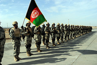
The Afghan Border Force (ABF) was responsible for security of Afghanistan's border area with neighboring countries extending up to 30 miles (48 km) into the interior and formed part of the Afghan National Army. In December 2017, most of the Afghan Border Police (ABP) personnel of the Afghan National Police were transferred to the Afghan National Army to form the Afghan Border Force. The ABP retained 4,000 personnel for customs operations at border crossings and international airports such as checking documents of foreigners entering the country or deporting them.
2014 Kunar Offensive refers to a 2014 armed conflict of the War in Afghanistan, between the Afghan Army and a terrorist group, Tehrik-i-Taliban Pakistan (TTP). It occurred in the Dangam district of eastern Kunar province, in Afghanistan bordering on Pakistan.

Mamund Tehsil is a subdivision located in Bajaur District, Khyber Pakhtunkhwa, Pakistan. Mamund is the largest tehsil of district Bajaur.

