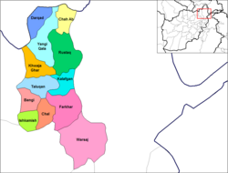
Khwaja Ghar District

Last updated

Khwaja Ghar District
Khwaja Ghar, Takhar Province.svg
Location of the district in Takhar Province
Coordinates: 37°04′N69°25′E / 37.06°N 69.42°E / 37.06; 69.42 Coordinates: 37°04′N69°25′E / 37.06°N 69.42°E / 37.06; 69.42
CountryFlag of the Taliban.svg  Afghanistan
Province Takhār Province
Plotted1973
District CenterKhwaja Ghar
Government
[1]
  GovernorMohammad Omar [lower-alpha 1]
  Police ChiefMohammad Ishaq
Area
[2]
   District 402 km2 (155 sq mi)
Population
 (2019) [3]
   District 74,769
  Density186/km2 (480/sq mi)
   Urban
7,917
   Rural
66,852
Ethnicity
[4]
  Uzbek70%
  Pashtun20%
  Tajik10%
  Hazara<1%
Time zone UTC+4:30 (Afghanistan Standard Time)
Post code
3760 [5]

Khwaja Ghar District is a district of Takhar Province, Afghanistan. The district was badly destroyed during the 1996-2001 Afghan Civil War in fighting between the Taliban and the Northern Alliance. [4]

Contents

Geography

Pre-2005 Map of Takhar Province Takhar districts.png
Pre-2005 Map of Takhar Province
Post-2005 Map of Takhar Province Takhar District Map.png
Post-2005 Map of Takhar Province

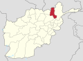
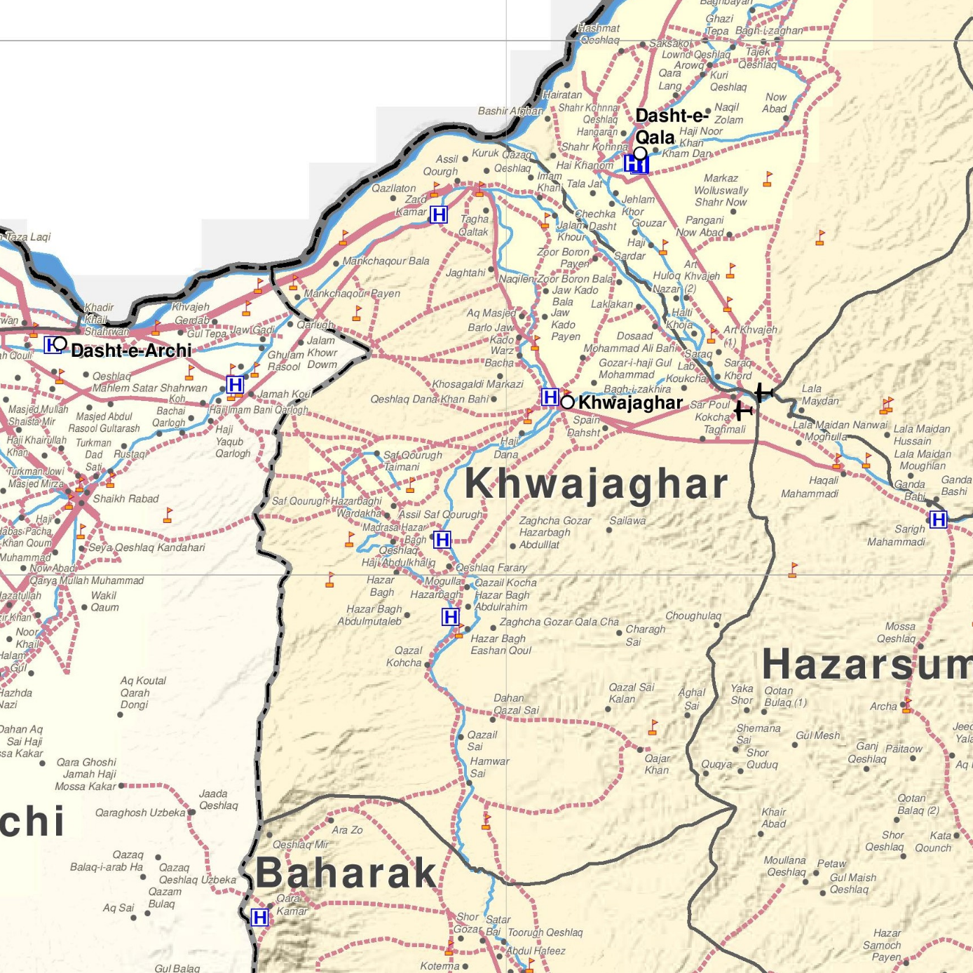
Khwaja Ghar has an area of 402 square kilometers, comparatively equivalent to the area of the Isle of Wight. [6] There are main roads connecting the district with Dasht-i-Archi, and Taloqan, the provincial capital, but they are mined. There is a smaller road connecting Khwaja Ghar with Dashti Qala District. [7] [4] Khwaja Ghar is located within the watershed of the Kokcha River and the Amu Darya River. [8]

Khwaja Ghar is bordered by Dashti Qala and Rustaq District to the northeast, Hazar Sumuch District to the east, Baharak District to the south, Dashte Archi to the west, and Khatlon to the north. Khatlon is a province located in Tajikistan, and Dashte Archi is located in Kunduz Province. All other districts it borders are located in Takhar Province. [9] [10]

History

Khwaja Ghar was first mapped by Mohammed Ashraf in 1973 to prepare for a census. [11]

Later, in 2001, the Taliban captured Khwaja Ghar in Early 2001, [12] and held it until November of that year. [13] The fighting was the heaviest in 20 years and destroyed much of the district. [4]

In 2005, Dashti Qala District was created from part of Khwaja Ghar. [14] [11] Mohammad Omar became district governor in 2006. [15]

The Taliban started challenging the government for control of Khwaja Ghar in early 2010, receiving support from insurgents in Dashte Archi District. In late 2010, much of the district was contested, Taliban controlled, or self governed. [12]

In August 2006, the Taliban took control of the district center for a short period of time before being pushed back by security forces. Civilians said that the locals were harassed while they were in the district center. [16] [17] The Taliban claimed that they controlled 20% of Khwaja Ghar in March 2017. [18] 10 villages were later taken by the Taliban in June of that year. [19] There have been many incidents in Khwaja Ghar since then. [lower-alpha 2] At the end of 2018, the district was considered to be insurgent influenced. [20]

Demographics

The district has a population of 74769 and a sex ratio of 21 males for every 20 females. Khwaja Ghar has an Uzbek majority with Pashtun and Tajik minorities. [4] The median age is 16.4 and about 40% of the population is working. 10% of the unemployed are seeking a job. The district is home to about 10,500 households, with an average size of 7.1 people. [9]

There are 62 villages located in this district. [2]

Economy

40% of employed people work in agriculture, hunting, fishing, or foresting- making it is the biggest sector in Khwaja Ghar. [9] The main crops are wheat, barley, cotton, and flax. There are about 14,000 hectares of irrigated land and 32,000 hectares of rain-fed land, but not all of the land is used. Irrigation is provided by the Taloqan River, but the water level is low by the time it reaches Khwaja Ghar. [4] Agricultural output is low due to lack of seeds, training, modern farming methods, equipment, and cold storage houses. [2] Livestock is also raised in the district, with mostly sheep and goats being raised. [12]

Another 30% of the workforce works in the service sector. [9] The majority of women work in weaving and tailoring. [2]

The district bazaar is one of the largest in the northeast, probably because of its proximity to Tajikistan. Khwaja Ghar benefits from cross-border trade, both legal and illegal. [12]

Education and Healthcare

Khwaja Ghar has a 50% literacy rate for people ages 15–24. [9] There are 5 secondary schools, 7 primary schools, and a religious school, with around 150 teachers. However, the schools are badly equipped and are in need of funds, teachers, buildings, and transportation.

The district has 3 health clinics and 9 pharmacies. Khwaja Ghar suffers from a lack of drinking water, doctors, and professional midwives. [4] [2] On 1 March 2020, one clinic was closed. [21]

Notes

  1. No relation to the former leader of the Taliban, Mohammed Omar.
  2. See here for specific instances

Related Research Articles

<span class="mw-page-title-main">Nimruz Province</span> Province of Afghanistan

Nimruz or Nimroz is one of the 34 provinces of Afghanistan, located in the southwestern part of the country. It lies to the east of the Sistan and Baluchestan Province of Iran and north of Balochistan, Pakistan, also bordering the Afghan provinces of Farah and Helmand. It has a population of about 186,963 people. The province is divided into five districts, encompassing about 649 villages.

<span class="mw-page-title-main">Takhar Province</span> Province of Afghanistan

Takhar is one of the thirty-four provinces of Afghanistan, located in the northeast of the country next to Tajikistan. It is surrounded by Badakhshan in the east, Panjshir in the south, and Baghlan and Kunduz in the west. The city of Taloqan serves as its capital.

<span class="mw-page-title-main">Panjshir Province</span> Province of Afghanistan

Panjshir is one of the thirty-four provinces of Afghanistan, located in the northeastern part of the country containing the Panjshir Valley. The province is divided into seven districts and contains 512 villages. As of 2021, the population of Panjshir province was about 173,000. Bazarak serves as the provincial capital.

<span class="mw-page-title-main">Bangi District</span> District in Takhār Province, Afghanistan

Bangi District is a district of Takhar Province, Afghanistan.

<span class="mw-page-title-main">Chah Ab District</span> District in Takhār Province, Afghanistan

Chah Ab District is a district of Takhar Province, Afghanistan. Its district center is Chah Ab. The district's economy is primarily based on agriculture and livestock.

<span class="mw-page-title-main">Chal District</span> District in Takhār, Afghanistan

Chal District is a district of Takhar Province, Afghanistan. It was considered to be largely under control of the Afghan government in 2018.

<span class="mw-page-title-main">Darqad District</span> District in Takhār Province, Afghanistan

Darqad District is a district of Takhar Province, Afghanistan. The district has 34 villages. Darqad did not change between the 325 and 398 district sets. Near the end of 2018, the district was considered to be Taliban-influenced, as opposed to the Afghan government. The district was Taliban-controlled by August 2021.

<span class="mw-page-title-main">Farkhar District</span> District in Takhar, Afghanistan

Farkhar District is a district of Takhar Province, Afghanistan. It is located southeast of Taloqan. The Khanabad River flows inside this valley. Around 99% of the people in Farkhar speak Persian. Farkhar has about 50,000 people and 75 villages.

<span class="mw-page-title-main">Kalafgan District</span> District in Takhār Province, Afghanistan

Kalafgan District is a district of Takhar Province, Afghanistan. The district is well governed, with self-governance in parts of Kalafgan because of how remote they are. 42 villages are located in the district. In 2017, Kalafgan was considered to be under full control by the Afghan Government. However, the Taliban had taken full control by August 2021.

<span class="mw-page-title-main">Rustaq District, Afghanistan</span> District in Takhār Province, Afghanistan

Rustaq District is a district of Takhar Province, northern Afghanistan. The district centre is the town of Rostaq. As recently as 2020, the district was considered to be under government control, as opposed to control by the Taliban. However, the district has had issues with illegal armed men.

<span class="mw-page-title-main">Warsaj District</span> District in Takhār Province, Afghanistan

Warsaj District is a district of Takhar Province, northern Afghanistan.

<span class="mw-page-title-main">Yangi Qala District</span> District in Takhār Province, Afghanistan

Yangi Qala District is a district in Takhar Province, Afghanistan. Economically the population of this district is primarily involved in agriculture. The main crops are rice and wheat, and the surplus rice is exporting to neighboring districts and provinces. There are 64 villages in the district. As of August 2021, the Taliban has full control over this district.

<span class="mw-page-title-main">Baharak District, Takhar</span> District in Takhār Province, Afghanistan

Baharak District is a district of Takhar Province, Afghanistan. The district was split-off from Taluqan District in 2005. Most people work in agriculture. The district has been the site of fighting between the Afghan Government and the Taliban; Baharak was considered to be contested in late 2018 and taken by the Taliban by August 2021.

<span class="mw-page-title-main">Dashti Qala District</span> District in Takhār Province, Afghanistan

Dashti Qala District is a district of Takhar Province, Afghanistan. It split from Khwaja Ghar District in June 2005. This district borders Tajikistan. Ai-Khanoum, probably founded by the Seleucid Empire, is located in this district. In 2018, this district was considered contested between the government and the Taliban.

<span class="mw-page-title-main">Namak Ab District</span> District in Takhār Province, Afghanistan

Namak Ab District is a district of Takhar Province, Afghanistan. The district was split-off from Taluqan District. In late 2018, Namak Ab was considered to be government influenced, as opposed to the Taliban.

<span class="mw-page-title-main">Hazar Sumuch District</span> District in Takhār Province, Afghanistan

Hazar Sumuch District is a district of Takhar Province, Afghanistan. The district was split-off from Taluqan District. Most people in the district work in agriculture. In late 2018, Hazar Sumuch was considered to be government influenced as opposed to the Taliban.

<span class="mw-page-title-main">Khwaja Bahauddin District</span> District in Takhār Province, Afghanistan

Khwaja Bahauddin District is a district of Takhar Province, Afghanistan. The district was created from a portion of Yangi Qala District in 2005. 25 villages are located in Khwaja Bahauddin.

Andkhoy District is a district in Faryab province, Afghanistan. The district center is the Andkhoy city, and there are a total of 81 villages in the district. Most people farm or raise livestock in the district. The district is considered to be government-influenced, as opposed to the Taliban.

Aqtash District is a district in Kunduz Province, Afghanistan. It was not part of the 399 or 407 district sets, but is recognized in the 422 district set as a temporary district. It was split from Khanabad District in late 2015 after a visit from Ashraf Ghani, the president of Afghanistan. In 2019, only two polling centers were open in the district, with 277 votes cast.

<span class="mw-page-title-main">Shahjahan Noori</span> Afghan Police Chief (1965–2011)

Shahjahan Noori, also known as General Shahjahan Noori, He was an Afghan guerrilla, military and police commander, during resistance against Soviet invasion and fight against terrorist groups such as Taliban and Al-Qaeda between 1981 and 2011.

References

  1. "Taliban Kill 4 Protestors Demonstrating in Khwaja Ghar District of Takhar". reporterly.net. 4 August 2020. Retrieved 10 August 2020.
  2. 1 2 3 4 5 "Khwaja Ghar District Development Plan" (PDF). mrrd-nabdp.org. Archived from the original (PDF) on 4 March 2016. Retrieved 10 August 2020.
  3. "Estimated Population of Afghanistan 2019-20" (PDF). Central Statistics Organization. 18 November 2019. p. 29. Archived from the original (PDF) on 9 June 2020. Retrieved 6 August 2020.
  4. 1 2 3 4 5 6 7 "Khwaja Ghar District Profile" (PDF). mrrd-nabdp.org. Archived from the original (PDF) on 27 October 2005. Retrieved 10 August 2020.
  5. "Khwaja Ghar Post Codes". worldpostalcodes.com. Retrieved 10 August 2020.
  6. "Islands by Land Area". unep.ch. Archived from the original on 16 July 2020. Retrieved 10 August 2020. 391.5 sq.km. Wight, Isle of
  7. "Takhar Maps Combined". nps.edu. AIMS. p. 8. Retrieved 10 August 2020.
  8. "Description of Watersheds" (PDF). aizon.org. p. 109. Retrieved 10 August 2020.
  9. 1 2 3 4 5 "Takhar Socio-Economic and Demographic Survey" (PDF). unfpa.org. UNFPA . Retrieved 10 August 2020.
  10. "Afghanistan Administrative Divisions" (PDF). aims.org.af. Archived from the original (PDF) on 23 September 2010. Retrieved 10 August 2020.
  11. 1 2 "Afghanistan District Maps". arcgis.com. Retrieved 11 August 2020.
  12. 1 2 3 4 Koehler, Jan; Gosztonyi, Kristof; Bohnke, Jan. "Conflict and Stability in Afghanistan: Methodological Approaches" (PDF). Retrieved 11 August 2020.
  13. Dr. Abdullah Abdullah (11 November 2001). "Abdullah Abdullah: Northern Alliance has Taken Taloqan". transcripts.cnn.com. CNN. Retrieved 11 August 2020.
  14. "398 District Division Matching to 329 District Division". aims.org. Archived from the original on 22 March 2016. Retrieved 11 August 2020.
  15. Reuter, Christoph (6 December 2019). "Why a Deal with the Taliban May Be Inevitable". spiegel.de. Retrieved 11 August 2020.
  16. Pajhwok Report (22 August 2016). "Fierce fighting on as security forces retake Khwaja Ghar". pajhwok.com. Pajhwok Afghan News. Retrieved 11 August 2020.
  17. "End of one hour Taliban presence in Khawaja". swn.af. 1 September 2016. Retrieved 11 August 2020.[ permanent dead link ]
  18. "Percent of Country under the control of Mujahideen of Islamic Emirate". alemaraenglish.net. Voice of Jihad. Archived from the original on 1 November 2022. Retrieved 11 August 2020.
  19. "Taliban captured ten villages in Takhar". 1tvnews.af. 18 June 2017. Archived from the original on 13 July 2017. Retrieved 11 August 2020.
  20. "Quarterly Report to the United States Congress" (PDF). sigar.mil. p. 71. Retrieved 11 August 2020.
  21. "Humanitarian Update (24 February- 1 March 2020)". reliefweb.int. Retrieved 10 August 2020.

Map of Khwaja Ghar

Map of Takhar Province