Afghanistan, officially the Islamic Republic of Afghanistan, is a landlocked country at the crossroads of Central and South Asia. Afghanistan is bordered by Pakistan to the east and south; Iran to the west; Turkmenistan, Uzbekistan, and Tajikistan to the north; and China to the northeast. Occupying 652,000 square kilometers (252,000 sq mi), it is a mountainous country with plains in the north and southwest. Kabul is the capital and largest city. The population is around 32 million, composed mostly of ethnic Pashtuns, Tajiks, Hazaras, and Uzbeks.

Jalalabad is the fifth-largest city of Afghanistan. It has a population of about 356,274, and serves as the capital of Nangarhar Province in the eastern part of the country, about 80 miles (130 km) from the capital Kabul. Jalalabad is located at the junction of the Kabul River and the Kunar River in a plateau to the south of the Hindu Kush mountains. It is linked by highways with Kabul to the west and the Pakistani city of Peshawar to the east including through the Khyber Pass.

Kabul is the capital and largest city of Afghanistan, located in the eastern section of the country. It is also a municipality, forming part of the greater Kabul Province, and divided into 22 districts. According to estimates in 2020, the population of Kabul is 4.222 million, which includes all the major ethnic groups of Afghanistan. Afghanistan's only city with a population of over 1 million, Kabul serves as its political, cultural and economical center. Rapid urbanization has made Kabul the world's 75th largest city.

Kandahar or Qandahar is a city in Afghanistan, located in the south of the country on the Arghandab River, at an elevation of 1,010 m (3,310 ft). It is Afghanistan's second largest city after Kabul, with a population of about 614,118. It is the capital of Kandahar Province and also the center of the larger cultural region called Loy Kandahar. In 1709, Mirwais Hotak made the region an independent kingdom and turned Kandahar into the capital of the Hotak dynasty. In 1747, Ahmad Shah Durrani, founder of the Durrani dynasty, made Kandahar the capital of the Afghan Empire.

Transport in Afghanistan has steadily improved in the last decade. Much of the nation's road network was built during the 1960s but left to ruin during the 1980s and 90s wars. New national highways, roads, and bridges have been rebuilt in the last decade to help increase travel as well as trade with neighboring countries. In 2008, there were about 700,000 vehicles registered in Kabul.

Kābul, situated in the east of the country, is one of the thirty-four provinces of Afghanistan. The capital of the province is Kabul city, which is also Afghanistan's capital and largest city. The population of the Kabul Province is over 5 million people as of 2020, of which over 85 percent live in urban areas. The current governor of the province is Muhammad Yaqub Haidari.

Khost is one of the 34 provinces of Afghanistan, located in the eastern part of the country. To the east, Khost Province is bordered by North Waziristan and Kurram in Pakistan. Khost Province used to be part of Paktia Province in the past, and the larger region surrounding Khost is still called Loya Paktia.

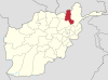
Nangarhār also called Nangrahar or Ningrahar, is one of the 34 provinces of Afghanistan, located in the eastern part of the country and bordering Logar, Kabul, Laghman and Kunar provinces as well as an international border with Pakistan. It is divided into twenty-two districts and has a population of about 1,836,000, the third highest of the country's 34 provinces. The city of Jalalabad is the capital of Nangarhar province.

Nuristan, also spelled Nurestan or Nooristan, is one of the 34 provinces of Afghanistan, located in the eastern part of the country. It is divided into seven districts and is Afghanistan's least populous province, with a population of about 140,900, Parun serves as the provincial capital. Nuristan is bordered on the south by Laghman and Kunar provinces, on the north by Badakhshan province, on the west by Panjshir province

The Grand Trunk Road formerly known as Uttarapath, Sarak-e-Azam, Badshahi Sarak, Sarak-e-Sher Shah is one of Asia's oldest and longest major roads. For at least 2,500 years, it has linked Central Asia to the Indian subcontinent. It runs roughly, 3,710 km (2,305 mi) from Teknaf, Bangladesh west to Kabul, Afghanistan, passing through Chittagong and Dhaka in Bangladesh, Kolkata, Allahabad (Prayagraj), Delhi, and Amritsar in India, and Lahore, Rawalpindi, and Peshawar in Pakistan.

Buddhism in Afghanistan was one of the major religious forces in the region during pre-Islamic era. The religion was widespread south of the Hindu Kush mountains. Buddhism first arrived in Afghanistan in 305 BC when the Greek Seleucid Empire made an alliance with the Indian Maurya Empire. The resulting Greco-Buddhism flourished under the Greco-Bactrian Kingdom and the later Indo-Greek Kingdom in modern northern Pakistan and Afghanistan. Greco-Buddhism reached its height under the Kushan Empire, which used the Greek alphabet to write its Bactrian language.

Khogyani is a district in the south of Nangarhar Province, Afghanistan, bordering on Pakistan. Its population is entirely Pashtun, and was estimated at 146,852 in 2002. The district is within the heartland of the Khogyani tribe of Pashtuns. The district centre is the village of Kaga. District Governor Office, District Court, District Hospital, and other government agencies hold their office in Kaga. Kaga is the economic center of the district; however Wazir is the second largest market place. Recently, Kaga town has been connected with Jalalabad City through paved road. Wazir is also connected through a paved road with Kaga.

Deh Yak is a rural district in the eastern part of Ghazni Province, Afghanistan, 30 km east from the city of Ghazni. The district has an area of 715 km2, containing 66 villages and a population of about 44,386. Ramak serves as the district's headquarters.

Shakardara District is situated in the central part of Kabul Province, Afghanistan. It has a population of 63,000 people, with another 10,000 expected to return from abroad.

The Tagab District is situated in the eastern part of Kapisa Province, Afghanistan. It borders with Parvan Province to the West, Mahmud Raqi and Nijrab in Nijrab is to the North, Alasay District to the East and Kabul Province to the South-East. The population is 71,700 (2006) - Pashtun and some Pashai. The district center is the village of Tagab, located in the western part of the district.

Sancharak District or Sangcharak is a district of Sar-e Pol Province, Afghanistan. Its center is the city of Tukzar or Tokzar. Sancharak district borders Balkh Province in the east. Sancharak District's area is 1089 square kilometres.

The War in Afghanistan is a war following the United States invasion of Afghanistan that began when the United States of America and its allies successfully drove the Taliban from power in order to deny Al-Qaeda a safe base of operations in Afghanistan. Since the initial objectives were completed, a coalition of over 40 countries formed a security mission in the country called International Security Assistance Force, of which certain members were involved in military combat allied with Afghanistan's government. The war has afterwards mostly consisted of Taliban insurgents fighting against the Afghan Armed Forces and allied forces; the majority of ISAF/RS soldiers and personnel are American. The war is code named by the U.S. as Operation Enduring Freedom (2001–14) and Operation Freedom's Sentinel (2015–present); it is the longest war in U.S. history.

The Khyber Pass is a mountain pass in the Khyber Pakhtunkhwa province of Pakistan, on the border with Afghanistan. It connects the town of Landi Kotal to the Valley of Peshawar at Jamrud by traversing part of the Spin Ghar mountains. An integral part of the ancient Silk Road, it has long had substantial cultural, economic, and geopolitical significance for Eurasian trade. Throughout history, it has been an important trade route between Central Asia and the Indian subcontinent and a vital strategic military choke point for various states that came to control it. The summit of the pass is 5 km (3.1 mi) inside Pakistan at Landi Kotal, while the lowest point is .46 km (0.29 mi) at Jamrud in the Valley of Peshawar. The Khyber Pass is part of Asian Highway 1 (AH1).

The Wakhjir Pass, also spelled Vakhjir Pass, is a mountain pass in the Hindu Kush or Pamirs at the eastern end of the Wakhan Corridor, the only potentially navigable pass between Afghanistan and China in the modern era. It links Wakhan in Afghanistan with the Tashkurgan Tajik Autonomous County in Xinjiang, China, at an altitude of 4,923 metres (16,152 ft), but the pass is not an official border crossing point. With a difference of 3.5 hours, the border has the sharpest official change of clocks of any international frontier. China refers to the pass as South Wakhjir Pass, as there is a northern pass on the Chinese side.
Operation Baawar, was a major Afghan-led offensive in Afghanistan west of Kandahar City. The operation took place primarily in a sector known as the Horn of Panjwaii. The combat operation started on December 5, 2010. Canadian troops from Task Force Kandahar, including those from the 1st Battalion Royal 22e Régiment Battle Group, worked with the Afghan National Army's 1st Brigade of the 205th (Hero) Corps as part of the larger Operation Hamkari. Part of Operation Baawar included Canadian and Afghan engineering units building 17 kilometres (11 mi) of road between Mushan and Sperwan Ghar.