Taloqan Airport | |||||||||||
|---|---|---|---|---|---|---|---|---|---|---|---|
| Summary | |||||||||||
| Airport type | Public/Military | ||||||||||
| Owner | |||||||||||
| Operator | Afghan National Security Forces (ANSF) ISAF | ||||||||||
| Serves | Taloqan, Takhar Province | ||||||||||
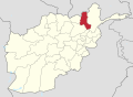
| Location | Taloqan, Afghanistan | ||||||||||
| Elevation AMSL | 2,606 ft / 794 m | ||||||||||
| Coordinates | 36°46′14.5″N69°31′56.7″E / 36.770694°N 69.532417°E | ||||||||||
| Map | |||||||||||
 KDH Location of airport in Afghanistan | |||||||||||
 | |||||||||||
| Runways | |||||||||||
| |||||||||||
Source: Landings.com [1] | |||||||||||
Taloqan Airport( IATA : TQN, ICAO : OATQ) is an airport serving the city of Taloqan (also known as Taluqan) in Takhar Province, Afghanistan. [2]