Maymana Airport میدان هوایی میمنه | |||||||||||
|---|---|---|---|---|---|---|---|---|---|---|---|
| Summary | |||||||||||
| Airport type | Public | ||||||||||
| Owner | Ministry of Transport and Civil Aviation | ||||||||||
| Serves | Maymana | ||||||||||
| Location | |||||||||||
| Elevation AMSL | 2,752 ft / 839 m | ||||||||||
| Coordinates | 35°55′50″N064°45′40″E / 35.93056°N 64.76111°E | ||||||||||
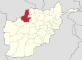
| Map | |||||||||||
 MMZ Location of Maymana Airport in Afghanistan | |||||||||||
| Runways | |||||||||||
| |||||||||||
| Sources: Landings.com, [1] Google Maps, [2] AIP Afghanistan [3] | |||||||||||
Maymana Airport( IATA : MMZ, ICAO : OAMN) is a domestic airport located in the northwestern section of Maymana, Afghanistan, which is the capital of Faryab Province.
Contents
Other nearby airports in Afghanistan are Andkhoy Airport in Faryab Province, Sheberghan Airport in Jowzjan Province, Chaghcharan Airport in Ghor Province, and Qala i Naw Airport in Badghis Province. [4]