Jalalabad is the fifth-largest city of Afghanistan. It has a population of about 356,274, and serves as the capital of Nangarhar Province in the eastern part of the country, about 130 kilometres (80 mi) from the capital Kabul. Jalalabad is located at the junction of the Kabul River and the Kunar River in a plateau to the south of the Hindu Kush mountains. It is linked by the Kabul-Jalalabad Road to the west and Peshawar in Khyber Pakhtunkhwa, Pakistan, to the east through Torkham and the Khyber Pass.

Kunduz is a city in northern Afghanistan and the capital of Kunduz Province. The city has an estimated population of about 268,893 as of 2015, making it about the seventh largest city of Afghanistan, and the largest city in northeastern Afghanistan. Kunduz is in the historical Tokharistan region of Bactria, near the confluence of the Kunduz River with the Khanabad River. Kunduz is linked by highways with Kabul to the south, Mazar-i-Sharif to the west, and Badakhshan to the east. Kunduz is also linked with Dushanbe in Tajikistan to the north, via the Afghan dry port of Sherkhan Bandar. This city is famous in Afghanistan for its watermelon production.

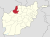
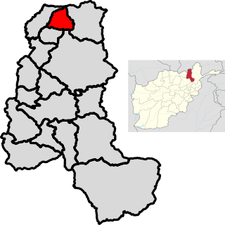
Kunduz is one of the 34 provinces of Afghanistan, located in the northern part of the country next to Tajikistan. The population of the province is around 1,136,677, which is mostly a tribal society; it is one of Afghanistan's most ethnically diverse provinces with many different ethnicities in large numbers living there. The city of Kunduz serves as the capital of the province. It borders the provinces of Takhar, Baghlan, Samangan and Balkh, as well as the Khatlon Region of Tajikistan. The Kunduz Airport is located next to the provincial capital.

Logar is one of the 34 provinces of Afghanistan located in the eastern section of the country. It is divided into 7 districts and contains hundreds of villages. Puli Alam is the capital of the province. As of 2021, Logar has a population of approximately 442,037 people, most of whom are ethnic Pashtuns and Tajiks.

Wardak, also called Wardag is one of the 34 provinces of Afghanistan, located in the central region of Afghanistan. It is divided into eight districts and has a population of approximately 500,000. The capital of the province is Maidan Shar, while the most populous district in the province is Saydabad District. Wardak is known for one of its famous high peak mountain known as. In 2021, the Taliban gained control of the province during the 2021 Taliban offensive.
Gurziwan is a district in Faryab province, Afghanistan. It was created in 2005 from part of Bilchiragh District.
Almar is a district in the southwestern part of Faryab province, Afghanistan. Its northern border is the national border with Turkmenistan. The population was estimated at 150,000 in 2013. Ethnic diversity includes 35% Turkmen and 65% Pashtun.
Khwaja Sabz Posh is the district where the Faryab province capital Maymana is located. It is a rural district without its own capital. The Khwaja Sabz Posh district is the closest district to the north of Maymana city. Khoja Sabz Posh is the name of a deceased village elder who was famous for always wearing the color green. There is a shrine dedicated to him on a hilltop just north of the Bazaar. It contains 85 villages. Ethnic diversity includes 80% Uzbek, 10% Pashtun and 10% Tajik.
Kohistan is the southernmost district in Faryab province. Its population is 53,100 (2010). The district center is Qal'a 35.3811°N 64.7561°E, 1909 m altitude.
Pashtun Kot is a district of Afghanistan, located in the centre of Faryab Province, south of the provincial capital Maymana. The district centre Pashtun Kot is a suburb of Maymana. The population is 277,000 (2002) with an ethnic composition of 85% Pashtun, 15% Turkmen.
Qaisar (Qaysar or Qeysar) (Persian: قیصار) is a district situated in the southwestern part of the Faryab province of Afghanistan. In 2021, the population was 400,000 with an ethnic composition of 70% Uzbek (Turkic origin), 16% Tajik, 10% Pashtun and 4% Turkman. The district center Qeysar (35.6894°N 64.2947°E,1279 m altitude) (Qaisar bazaar), at the edge of the vast desert of Qaisar, has almost the same peculiarities of the Almar bazaar. This bazaar received its name at the end of the nineteenth century.
Khwaja Umari is a district in Ghazni province, Afghanistan. It was created in 2005 from the large Jaghatu District. The district center is the village of Khwaja Umari.

Alishing District is a district in Afghanistan, located 21 km from Mihtarlam, the provincial centre of Laghman Province. It has borders with Kabul and Kapisa provinces to the West, Dawlat Shah District to the North, Alingar District to the East and Mihtarlam District to the South. The district center is the village of Alishang, located on 34.7044°N 70.1539°E at 862 m altitude. There are 12 zones, each with around 12 to 14 villages located in the valleys and mountains. The Alishing river crosses the district and is the main source of irrigation.
Dawlat Shah District is located approximately 74 km from Mehterlam, the provincial centre of Laghman Province in Afghanistan. It is a mountainous district and borders Nuristan Province to the North and North-East, Alingar District to the East, Alishing District to the South and Kapisa and Parwan provinces to the West. The population is 36,950 (2019) - 70% Pashai, 29% Tajik and 1% Pashtun. It has 60 villages. The district center is the village of Dawlat Shah, located on 34.9528°N 70.07°E at 1583 m altitude in the Hindukush mountains in the valley of the Alishing river. On 20 May 2021 it was captured by Taliban.

Saydabad District is a district of Maidan Wardak Province, Afghanistan. The district is known for its pleasant climate, including hilly vegetation, streams, and orchards. The district was a popular retreat for Kabul residents until an increase in ISAF-Taliban violence in the late 2000s. The city of Saydabad serves as the district capital. With a population of 114,793, it is the most populous district of the province.
Yangi Qala District is a district in Takhar Province, Afghanistan. Economically the population of this district is primarily involved in agriculture. The main crops are rice and wheat, and the surplus rice is exporting to neighboring districts and provinces. There are 64 villages in the district. As of August 2021, the Taliban has full control over this district.
The following lists events from 2014 in Afghanistan.
The following lists events that happened in 2013 in Afghanistan.

The Battle of Kunduz took place from April to October 2015 for control of the city of Kunduz, located in northern Afghanistan, with Taliban fighters attempting to seize the city and displace Afghan security forces. On 28 September 2015, the Taliban forces suddenly overran the city, with government forces retreating outside the city. The capture marked the first time since 2001 that the Taliban had taken control of a major city in Afghanistan. The Afghan government claimed to have largely recaptured Kunduz by 1 October 2015 in a counterattack, although local sources in the city disputed the claim made by government officials.
The year 2021 in Afghanistan was marked by a major offensive from the Taliban beginning in May and the Taliban capturing Kabul in August.