Ghōr, also spelled Ghowr or Ghur, is one of the thirty-four provinces of Afghanistan. It is located in the western Hindu Kush in central Afghanistan, towards the northwest. The province contains eleven districts, encompassing hundreds of villages, and approximately 764,472 settled people. Firuzkoh serves as the capital of the province.

Chaghcharān, also called Firozkoh, is a town and district in central Afghanistan, which serves as the capital of Ghor Province. It is located on the southern side of the Hari River, at an altitude of 2,230 m above sea level. Chaghcharan is linked by a 380 kilometres (240 mi) long highway with Herat to the west, and a 450 kilometres (280 mi) long highway with Kabul to the east. The town is served by Chaghcharan Airport.
Sangi Takht or Sang‐e‐Takht, is a district in Daykundi Province in central Afghanistan. It was created in 2005 from Daykundi district.
Chaghcharan District is one of the most populated districts in Ghor province. It is a mountainous district. The winter is severe and the roads are inaccessible because of the snow. The district center of Chaghcharan is also the capital of the province. The drought has seriously affected agriculture — the main source of income. There are a hospital and secondary schools in the district center, but because of the bad roads and severe weather they are hardly accessible to the rural population.
Charsada District is a District of Ghor province, Afghanistan. It was created from the northwestern part of Chaghcharan District in 2005. The district center is Qale-Zobayd. The population is 26,600.
Qale Zobayd village is the center of Charsadda District, Ghor province, Afghanistan. It is situated on 34.9156°N 65.2878°E at 1,977 m altitude.
Dawlat Yar is a district in Ghor Province, Afghanistan. It was created in 2005 from the southeastern part of Chaghcharan District. The administrative center of the district is Delak, but the largest town is Dawlat Yar at 2503 m altitude.
Delak is the district center of Dawlat Yar district, Ghor province, Afghanistan. It has an elevation of 2,789 metres (9,150.3 ft)
Lal (La'l) sometimes called Lal wa Sarjangal is a town and the administrative center of Lal wa Sarjangal District, Ghor province in central Afghanistan.
Pasaband District is located in Ghor province, Afghanistan. The population is 92,900. Located in the southern part of Ghor province, Pasaband District borders Helmand province to the south, Daykundi province to the east, and Farah province to the southwest. The district center is Shinkot.
Saghar District is situated in the most southwestern part of Ghor province, Afghanistan with district center Titan. The population is 33,700 people. The district, as the other mountainous districts in the province, suffers long and severe winters and continuing drought during the summer.

Shahrak District is located in the western part of Ghor province, Afghanistan. The population is 58,200. The district center is Dahan-e Falezak.
Taywara (Teyvareh) district is located in the southern part of Ghor province in Afghanistan. The population is 88,900 people. The district center is the town of Taywara.
Tulak District is located in the southwestern part of the Ghor province, Afghanistan. It is a mountainous district like the whole province. The population is 103,612 and the district center is Kwajaha.

Chishti Sharif District, also known as Chisht District, is the most easterly district in Herat Province, Afghanistan, situated along the Hari River and one of its northern tributaries. It borders with Obe District to the west, Badghis Province to the north and Ghor Province to the east and south. The population was estimated at 23,100 in 2012. The district administrative center is the village of Chishti Sharif.
Farsi is a district the west of Herat Province, Afghanistan. It borders on Obe District to the north, Adraskan District to the west, Shindand District to the south and Ghor Province to the south and east. The population was estimated at 29,800 in 2012. The district center is the village of Farsi.
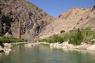
Firozkoh, or Turquoise Mountain, was the summer capital of the Ghurid dynasty, in the Ghor Province of central Afghanistan. It was reputedly one of the greatest cities of its age, but was destroyed in 1223 after a siege by Tolui, son of Genghis Khan. The location of the city was lost to history. It has been proposed that the Minaret of Jam, in Shahrak District, Ghor Province, is the only standing remains of the city.
Saghar is a village in Saghar District in Afghanistan's Ghor Province. It is located at 33°42'0N 63°52'0E with an altitude of 2235 metres (7335 feet).

Marghab District , is a district located in Ghor Province, Afghanistan, created on 26 November 2019. Shorabak area serves as the district center. President Ghani decreed the creation of the district through decree No. 632 from the Presidential Palace. It was the people's demand. The district encompasses 32 villages and around 19,000 people, Marghab District has approximately 40000 inhabitants and is mainly populated by Tajiks.
On 20 October 2017, suicide bombers attacked mosques in Kabul and Ghor Province, Afghanistan, killing at least 60 people.

