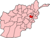
Kabul, situated in the east of the country, is one of the thirty-four provinces of Afghanistan. The capital of the province is Kabul city, which is Afghanistan's capital and largest city. The population of the Kabul Province is over 5.5 million people as of 2022, of which over 85 percent live in urban areas. The current governor of the province is Qari Baryal.

Logar is one of the 34 provinces of Afghanistan located in the eastern section of the country. It is divided into 7 districts and contains hundreds of villages. Puli Alam is the capital of the province. As of 2021, Logar has a population of approximately 442,037 people, most of whom are ethnic Pashtuns and Tajiks.

Paghman (Dari/Pashto:پغمان) is a town in the hills near Afghanistan's capital of Kabul. It is the seat of the Paghman District which has a population of about 120,000, mainly Pashtuns and Tajiks. The gardens of Paghman are a major tourist attraction, and the reason for the city being known as the garden capital of Afghanistan. The neighboring town of Qargha is to the southeast, which can be reached by several roads.

Qarabagh District is located 50 kilometers north of Kabul City in Afghanistan, and 20 kilometers southeast of Bagram Airbase. The district is part of Kabul Province and is on the route between Kabul and Parwan Province. It has a population of 15,000, with an expected 19,000 more people to return from Pakistan and Iran in the future. As of 2002 around 60% of the population are Tajiks and 40% Pashtuns.

Goshta District is located in the northeast of Nangarhar Province, Afghanistan and borders Durand Line between Afghanistan and Pakistan. The district's population is Pashtun and was estimated at 160,000 in 2002, of whom 30,000 were children under 12. The district is within the heartland of the Mohmand tribe of Pashtuns. The district centre is the village of Goshta, on the Kabul River.
Bagrami District is located in the central part of Kabul Province in Afghanistan. It is approximately a 30-minute drive east from the capital city, Kabul. The district headquarters is the town of Bagrami.

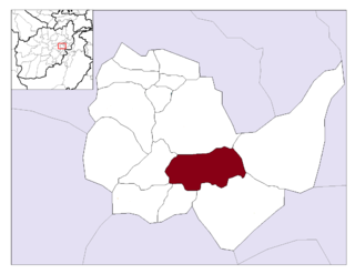
Char Asiab District is a district, approximately 11 km south of the city of Kabul, and is situated in the southern part of Kabul province, Afghanistan. It has a population of 32,500 people. The majority are Pashtuns, followed by Tajiks as well as a few Hazaras.
Tara Khēl is a village and the center of Deh Sabz District, Kabul Province, Afghanistan. It is situated northwest of Kabul at 34.5767°N 69.2564°E at 1794 m altitude. The village is big, with more than 2,000 households. It is close to the Kabul International Airport. The Tarakhelis, a Pashtun tribe, are the main inhabitants of the village, thus the name Tarakhel
Istalif District is located in the northwestern part of Kabul Province, Afghanistan. It has a population of 8,500, a mixture of Tajiks, Pashtuns and Hazaras.

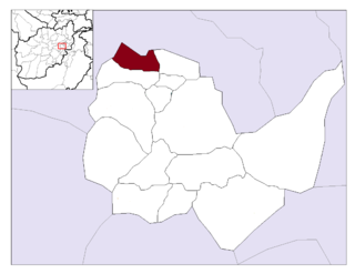
Mir Bacha Kot District is situated in the central part of Kabul Province, Afghanistan. It has a population of 5,000 and another 37,000 are expected to return in the near future. Tajiks are the majority and some Pashtuns also live there.

Mussahi District is a southern district of Kabul Province, Afghanistan. Mussai district borders Char Asiab District to the west, Bagrami District to the north, Khaki Jabbar District to the east and Logar Province to the south. Its headquarter is in Mussahi village, which is in the central part of the district.

Paghman District is in the western part of Kabul Province, Afghanistan. It has a population of over 120,000 people.

Shakardara District is situated in the central part of Kabul Province, Afghanistan. It has a population of 3,000 people, with another 10,000 expected to return from abroad.

Surobi, Sarobi, or Sarubi District is a district of Kabul Province, Afghanistan. Its capital, Surobi, lies about 60 kilometres east of Kabul along the A01 highway, although much of the district lies northeast of Kabul. Surobi is famous all over Afghanistan as it is birthplace to Faisal Babakarkhail a well known Jihadi commander famous for his bravery and courage against Soviet Troops. Its principal river is the Kabul River.

Mihtarlam District is located in the center of Laghman Province and consists of the urban centre and provincial capital Mihtarlam and 24 major villages and 269 sub-villages.
Farza District, also referred to as Farza, is district of Kabul Province, Afghanistan, with a population of 18,000 people. It's located 45 km north of Kabul, in the hills of the northwestern part of the Shomali Plain, and south of the villages of Istalif and Qarabagh. Farza District contains eighteen villages. The district headquarters is Dehnawe Farza. According to the UNHCR, in 2002, the population consisted of a mixture of Pashtuns and Tajiks.
The Tagab District is situated in the eastern part of Kapisa Province, Afghanistan. It borders Parvan Province to the West, Mahmud Raqi and Nijrab districts to the North, Alasay District to the East and Kabul Province to the South-East. The population is 71,700 (2006) with Pashtun being the majority and the Pashai a minority. The district center is the village of "Tamir" (تعمیر) in Dari, located in the western part of the district.
Mohammad Agha District is a district of Logar Province, Afghanistan. It lies just south of Kabul Province. The district capital is Mohammad Agha. The Afghan government plans to build a new international airport in this district.

Kote Sangi is a neighborhood and major intersection in western Kabul, Afghanistan, mostly part of District 5 with some parts in District 3. It is one of the city's most populated urban areas, located south of the Silo Road and west of Deh Bori and Kabul University. The roads link it to Afshar, Darulaman, Paghman and downtown Kabul. To the south-west are shanty areas nearby Dasht-e Barchi. In 2011 the country's first skyway, Kote Sangi Bridge, was built there which is 650 m long and 14 m high. Its location is centered on Mirwais Maidan.
The Tarakhel, or Torakhel, are a Pashtun sub-tribe of the Ghilji tribe. They can trace their origins back to Kochi nomadic Pashtuns from Zabul. The name 'Tarakhel' originally comes from the word Tora which means sword in Pashto and 'khel' is the suffix for Pashtun tribes. Therefore, the name of this tribe in the Pashtun literature is 'Torakhail' which is translated to the clan of swords or the clan of swordsmen. The people of Tarakhel are divided into two parts in Kabul, the main tribe which resides in Deh Sabz District district of Kabul and the nomad Tarakhelis who are residing in 'Pol-e Charkhi' area of Kabul. They are mainly found in the Deh Sabz district of Kabul and Laghman but also in parts of northern Afghanistan, such as Baghlan and Samangan.